MILITARY RAILROADS OF THE NEW YORK METROPOLITAN AREA:
GOVERNOR'S ISLAND / FORT JAY
Governors Island, New York
GIRR US Army
.
|
updated:
|
|
|
update summary |
date |
| High quality National Archives photos of locomotives, float bridges and construction | 01/16/2018 |
.
Special thanks to George Lane for forwarding the images from the National Archives!


.
.
The Governors Island Railroad was
constructed to service the extensive array of supply warehouses located
on Governors Island. When you consider how much materiel the
Quartermaster must deal with on a daily basis (not to mention the
storage of): uniforms for different seasons, clothing accessories
(belts, hats, gloves), weapons accessories (shoulder slings, belt
ammunition pouches), mess kits (forks, knives, spoons, meal trays),
food (Iron & Reserve Rations - predecessors to C & K
rations) canteens, backpacks, gas masks, ponchos,
tents, toothbrushes, etc. You name it, and if it wasn't a weapon
or a vehicle; it pretty much went through the Quartermaster.
Moving these supplies from government contractor / manufacturer factory to the supply depot is pretty straight forward and as we seen, most military supply depots had rail networks to facilitate movement in receiving, shipping and transfer from one warehouse to another.. That is all simple until that depot is located on an island without a bridge. Then you need float bridges and carfloat service! But the puprpose of the railroad is the same.
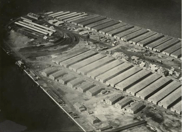
It has been said in many discussions that the Governors Island Railroad consisted of 1 ¾ miles of track, and of which originally had three flat cars carrying coal, machinery and supplies from the pier to shops and warehouses.
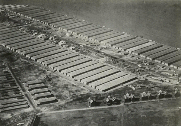
After reviewing track maps and photos, I came to the conclusion that the Army expanded the trackage to cover almost the entire length of the island, with many more cars (primarily box cars) that are present in the Fairchild Aerial Survey Photographs below.
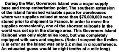
However, it also occurred to me after reading an email letter from Steven Delibert (whom I knew casually from his interests in Ulster & Delaware County, NY railroad history and personal friend of my uncle), that original trackage was 8 miles, reduced to 1 ½ miles. Another comment from and unidentified source doubts the eight mile figure.
email from Steven Delibert containing excerpt of April
1931, Railroad Mans Magazine
courtesy of A. Audley
added 11 June
2010
.
.
The following commentary disputes that figure:
http://www.govislandarmybrat.com/IslandHistory4.html
courtesy of A. Audley
added 11 June
2010
.
.
So where does this figure of 8 miles come from? Well, I think I have figured it out:
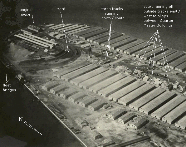
First, the the length of the island is about 2.2 miles, and reviewing the map below, trackage ran completely to the northeast end. A single track running from the enginehouse to the northeast end of track would be approximately 1 ½ miles. But careful review of the map and Fairchild Aerial photos below, shows THREE tracks running parallel to each other up the center of the island, from the enginehouse to the northeast end of the island.
1½ miles multiplied by 3 tracks equals 4½ miles. Factor into this figure the yard stubs AND the spurs in the alleys between the storehouses and tracks in the storehouses, and you would arrive at a figure very close to the 8 miles.
Therefore it is my hypothesis that the concluding figure of 1½ miles of trackage probably denotes the overall length of the layout, not the cumulative amount of trackage laid which might have totaled 8 miles.
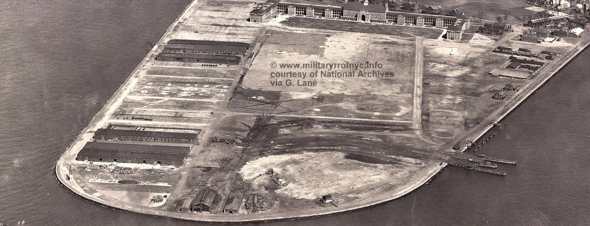
In any event, the trackage that can be seen in the 1918 Fairchild Aerial Survey Photograph below (looking southwest) with authors annotations, show a rather modest sized railyard built on the curve to the east leading to a pair of wood Howe Truss floatbridges (very difficult to see in this photo), and what appears to be an enginehouse on the southern tip of the inland.
On 24 May 2010, I received an email from Art Audley who furnished the following items. His emails contained some very interesting images and scans pertaining to both the construction and demolition of the Governors Island Railroad.
The first item, is a map denoting the locations of construction contracts. It is referenced in the documents below as a plot plan. However, it doubles very nicely as a track map!
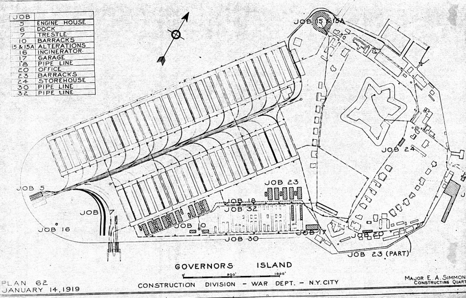
courtesy of A. Audley
added 25 May
2010
.
.
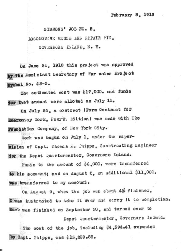
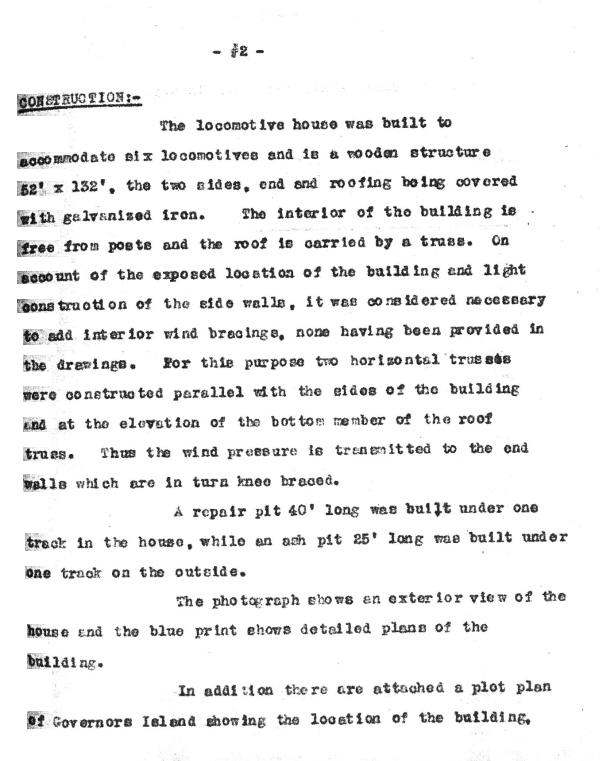
The following, also furnished by Art Audley, appear to be a construction summary by the Constructing Quartermaster, Major E. A. Simmons:
|
|
|
 |
courtesy of A. Audley
added 11 June
2010
.
.
The following is a copy of the photo of the completed enginehouse:
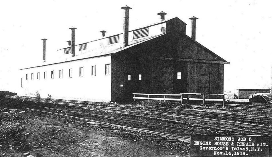
November 14, 1918
courtesy of A. Audley
added 11 June
2010
Three tracks heading up roughly the center of the island (running north / south) from the enginehouse, with the outside two tracks splitting off to the east and west and into alleys between the Quartermaster Supply Buildings.
(For your viewing pleasure, there is an non-annotated photo in photo section below.)
.
In the picture below, taken ca. 1927 (and looking due north) we clearly see in the close up at bottom right; the two Howe Truss float bridges (the southern one already with a sunken pontoon) and the northern float bridge with a carfloat moored.
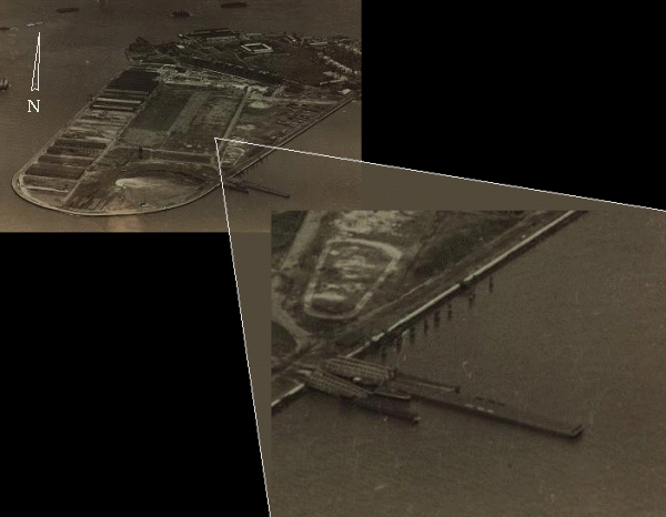
.
That carfloat by the way, appears to be a New York Dock carfloat.
I believe this to be on several counts:
the sign boards are approximately of equal size, and the words in: |
NEW | | YORK | | DOCK | are relatively equal in length, and
no other railroad in New York City area had a name that was of relative equal
length in three words, and;
the Atlantic Terminal was just a short tug haul away: approximately 2000 feet across Buttermilk Channel!
Unfortunately, any attempts to "zoom" any closer on the photo only pixelates the image worse.
You can see all too well in the regular view (top left) that: all the east side as well as some of the west side Quarter Master Buildings, the enginehouse, and most of the yard trackage has already been removed.
For all intents and purposes
this railroad did not last long, likewise other small military base
railroads in the New York Metropolitan Area like the US Navys' Fleet
Supply Base located in South Brooklyn., which also ordered four
locomotives in 1919 and sold them off by 1922.
Now, ascertained from the locomotive pictures
below; it is seen that:
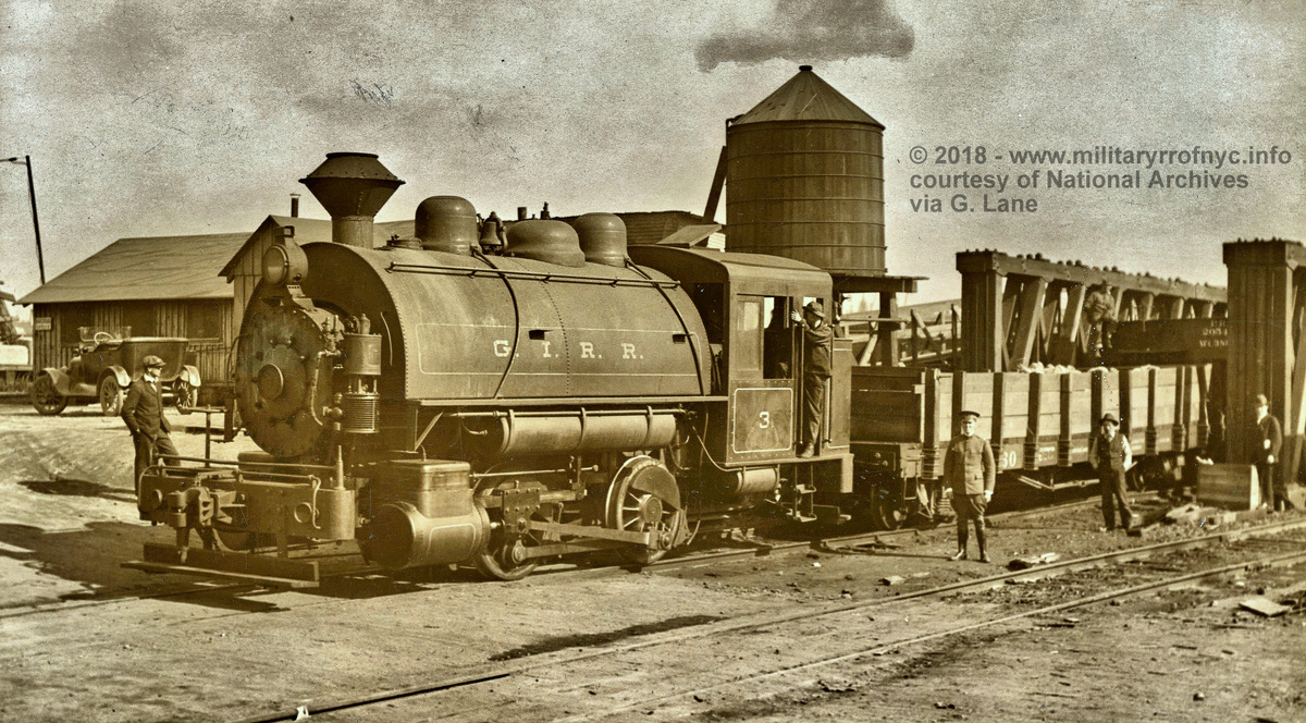
GIRR #3 hauling a wood sided flatcar bearing the number 60 off of a Howe Truss style float bridge;
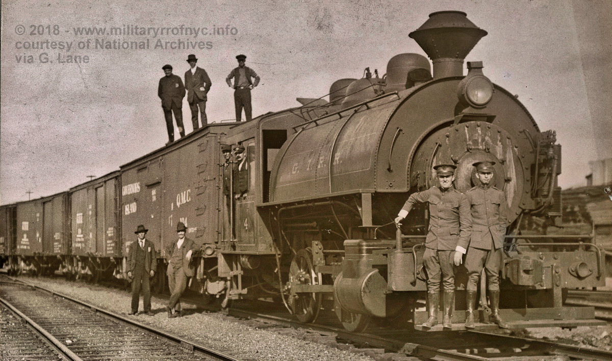
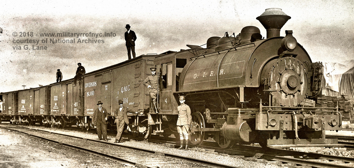
GIRR #4 has boxcars marked: Governors Island Q.M.C. 104 and G.I.R.R.108 with a third boxcar end just showing.
Couplers are Janney style with notch for link and pin.
Track appears to standard gauge.
Never-the-less; many questions abounded at first, some of which were answered over time.
Extensive research of authors H. K. Porter builders records, reveal numerous locomotive entries for US Army and QMC, but none show conclusively they were assigned to, or operated at Governor's Island.
This author has discovered in the ALCo builders records, four 0-4-0T steam locomotives built by ALCo Schenectady, that fit the numbering sequence and locomotive type that correspondes with the date that the GIRR was built and the fact the locomotives were ordered by the Quartermaster Division. (QMD). I now believe that the locomotives are ALCO products not H. K. Porter, and the roster below has been changed to reflect this. Unfortunately, build specs are not listed, (i.e.: cylinder size, driver diameter).
In the winter of 2017/2018, I received several images from George Lane who had forwarded several images from the National Archives in College Park, MD. Some of these images (of the locomotives) had been seen before in less than stellar quality. But a few were images we had not encountered and were of the infrastructure of the Governors Island Railroad. As these images trickled in and were examined, subtle details began to emerge. Thanks to these images, we know can ascertain that several railroads (and not just one) in New York Harbor provided service to Governors Island. This was ascertained by their carfloats can be seen in the photos taken from the water off the float bridges: New York Central or New York New Haven & Hartford "C41" tied up along the bulkhead and an Erie Railroad "390" at the north float bridge.
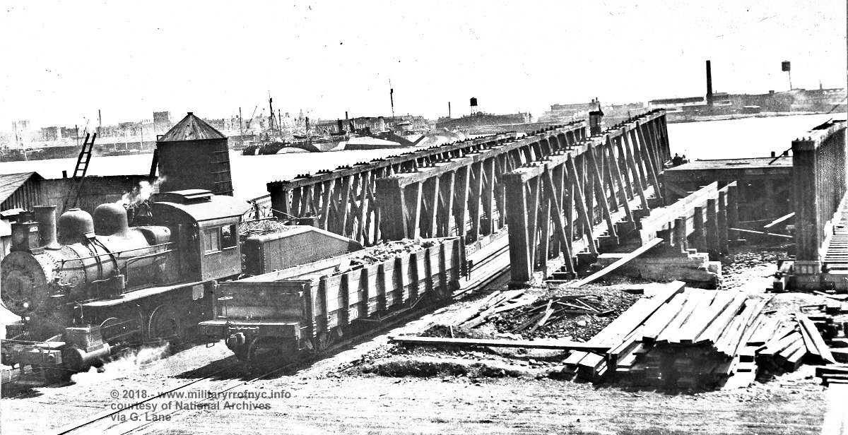 September 24, 1918 The appearance of this locomotive at this location raises questions. If the date on the photo is correct (and we have no reason to conclude otherwise), all four GIRR saddletankers were built by this date and should be present for service. Therefore why would this locomotive have been needed on? Furthermore, this style of locomotive (loco & tender) is interesting. Being that such a short distance of trackage was installed on Governors Island, and obviously with the water tank in the images, water was readily available. Therefore the tender would not have given the locomotive any advantage over the saddletankers. Perhaps the saddletankers had not yet been delivered? In any event, it is not believed that the locomotive in this photo was part of the GIRR roster, but simply brought in during construction by the contractor. Upon closer examination of the image, this locomotive appears to be a Pennsylvania Railroad A4 class 0-4-0 (note Belpaire firebox, large cab clerestory and slopeback tender. While difficult to discern upon enlargement, it appears to carry number 253 as seen on the kerosene fired headlight numberboard. As the PRR Class A4's had already been superceded by first batch of the improved A5 0-4-0 in 1916, this locomotive may already be working secondhand for a contractor. Further reinforcing this hypothesis, is said contractor is mentioned in the construction summary as documented by Major E. Simmons, USA QMC dated February 8, 1919 and can be seen above. Also, judging by the date and the amount of good construction material, this appears to be an under construction image, as opposed to say, a demolition & debris removal. Also, that "temporary transport landing" was not temporary and a standard Howe Truss float bridge, one of two that were installed at Governors Island as it was used for the entire life of the GIRR. Oddly enough, the right float bridge does not seem to be sitting level with the ground, and therefore must not be in service. Note the naval ships at anchor in the background wearing "dazzle" camoflage, and barely discernable behind them is the storehouse side advertising of the New York Dock Company Atlantic Stores. 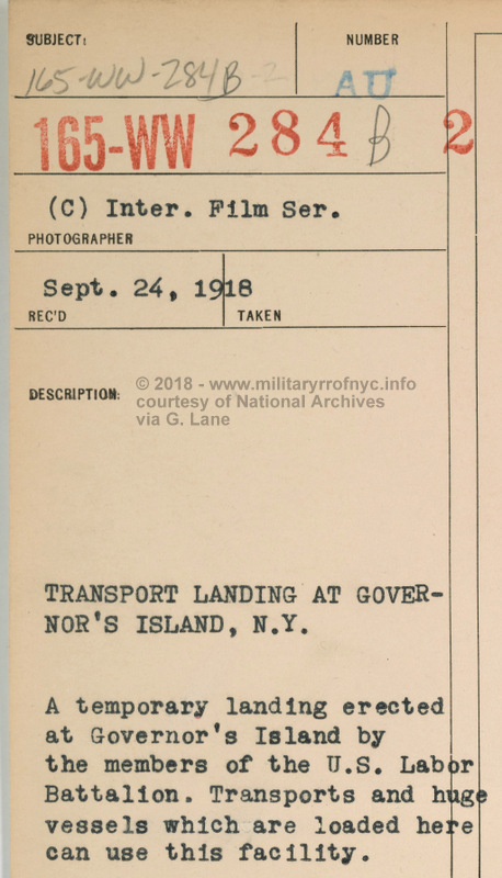 courtesy of the National Archives Records Administration, College Park, Md - 1918
submitted by George Lane re-uploaded 05 January 2018 |
| . . |
|
|
| .
. |
|
|
| .
. |
 circa 1918 Lieutenant Philip J. O'Brien (leaning out of locomotive cab door). courtesy of the National Archives Records Administration, College Park, Md submitted by George Lane re-uploaded 05 January 2018 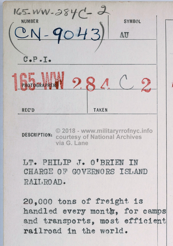 courtesy of the National Archives Records Administration, College Park, Md submitted by George Lane re-uploaded 05 January 2018 |
| .
. |
 courtesy of the National Archives Records Administration, College Park, Md - 1918
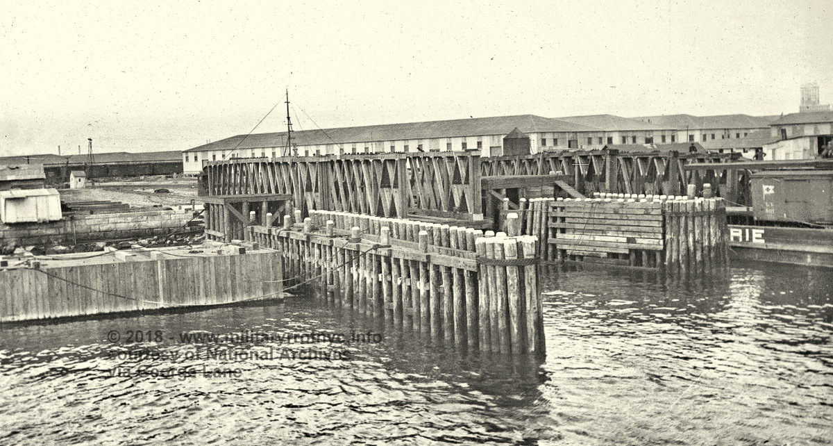
That slatted box in the water on the left edge of photo? That is a brand new pontoon for the south float bridge. In the next image below you can discern that the float bridge is resting on piles. Also, note the carfloat marked for Erie. submitted by George Lane
re-uploaded 14 January 2018
|
| .
. |
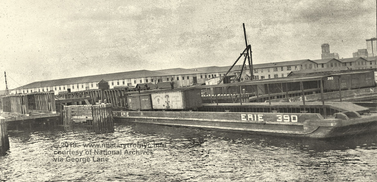 courtesy of the National Archives Records Administration, College Park, Md - 1918 Erie RR station carfloat #390 and NYC? NYNH&H? station carfloat #C41 Note the bulkhead unloading shed, situated parallel to the bulkhead between the A Frame derrick and right edge of image) so carfloats can be moored and accessed without having to be bridged. submitted by George Lane re-uploaded 14 January 2018 |
| .
. |
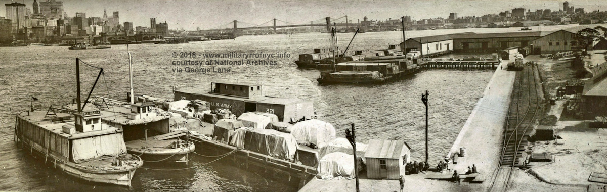 |
| .courtesy of the National Archives Records Administration, College Park, Md - 1918 Governors Island north bulkhead Interesting to note that the US Army had its own covered barges! submitted by George Lane re-uploaded 16 January 2018 |
| .
. |
|
|
| .
. |
|
|
| . . |
 March 1931
courtesy of the National Archives Records Administration, College Park, Md submitted by George Lane re-uploaded 05 January 2018 |
.
.
The last two significant items, were also furnished by Art Audley.
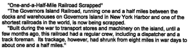
The first is the newspaper article from the February 12, 1931 issue of the New York Times concerning the scrapping of the Governors Island Railroad.
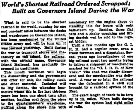
New York Times - February 12, 1931
courtesy of A. Audley
added 11 June
2010
.
.
The last item, is a Rogers Map dated 1934, and was located in the Library of Congress. It is my intent to secure a better copy in the future, but we can see that the storehouses in the center of the island have already been demolished, but the railyard, enginehouse and it appears the float bridges are still in place.
Therefore is seems highly probable that the railroad was used to transport demolition material to the yard, possibly the float bridges; to be removed from the island. But, this is not confirmed.
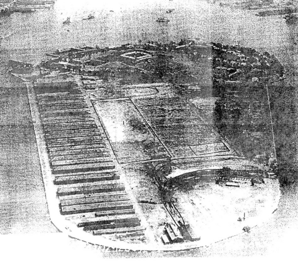
Rogers Map -1934
Library of Congress
courtesy of A. Audley
added 11 June
2010
..
.
Governor's Island Rail Road Locomotive
Roster
| builder | c/n | build date | gauge | wheel arrangement |
wheel dia |
cylinders | acquired | number / name | disposition | notes | ref |
| Baldwin | 25743 | 5/1905 | 36" | B | new | 20 hp electric | [2] | ||||
| ALCo (Schenectady) | 56991 | 12/1917 | std. | 0-4-0T | #1 | US War Dept QMD | [1] | ||||
| ALCo (Schenectady) | 56992 | 12/1917 | std. | 0-4-0T | #2 | US War Dept QMD | [1] | ||||
| ALCo (Schenectady) | 59407 | 6/1918 | std. | 0-4-0T | #3 | US War Dept QMD | [1] | ||||
| ALCo (Schenectady) | 59408 | 6/1918 | std. | 0-4-0T | #4 | US War Dept QMD | [1] | ||||
| Plymouth | 4134 | 1/23/1941 | 23 5/8" | to Fort Dix, Post Utilities #999 unknown date |
DLB 6 8 Ton |
[6] | |||||
| Plymouth | 4135 | 1/23/1941 | 23 5/8" | to Fort Dix, Post Utilities #13 unknown date |
DLB 6 8 Ton |
[6] |
Index:
|
Military
Railroads of the New York Metropolitan AreA |
||||
| Earle N.A.D. N.W.S. Earle |
||||
| Fort Totten | Fort Terry | Fort Hancock / Sandy Hook Proving Grounds | ||
| . Sign The Guestbook |
||||
.