INDUSTRIAL & TERMINAL RAILROADS & RAIL-MARINE OPERATIONS OF BROOKLYN, QUEENS, STATEN ISLAND, BRONX & MANHATTAN:
RAILROAD
OPERATED PIER STATIONS & INLAND FREIGHT
STATIONS
OF MANHATTAN
Less Than Carload Car Load LCL
.
|
updated: |
||
|
|
||
|
update summary: |
date: | chapter: |
| Pier Station Overview expanded, new diagrams and images | 15 July 2026 | Pier Station Overview |
| Hudson River pier table expanded by date | 23 April 2026 | |
.

.
.
| 1943 Facilities Map | Pier Station Location Chart & Photo Album | |
| Inland Freight Station Overview | Inland Freight Station Photo Album |
.
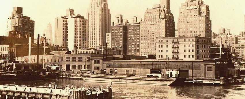
This page consists solely of pier stations or inland
freight stations that were simply that:
a pier station or inland freight station with no other adjoining railroad
facility, float bridge, or trackage.
Pier Stations with adjoining railroad operations are shown on their respective Offline Freight Terminal pages.
.
|
|
.
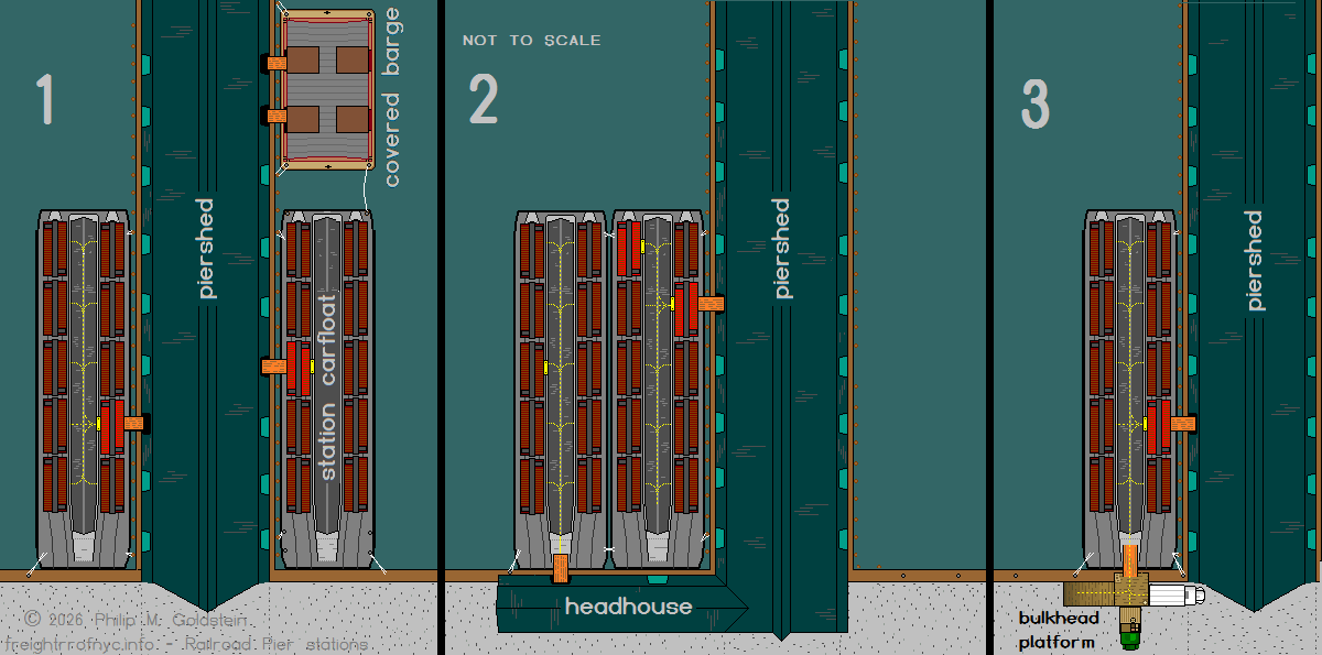
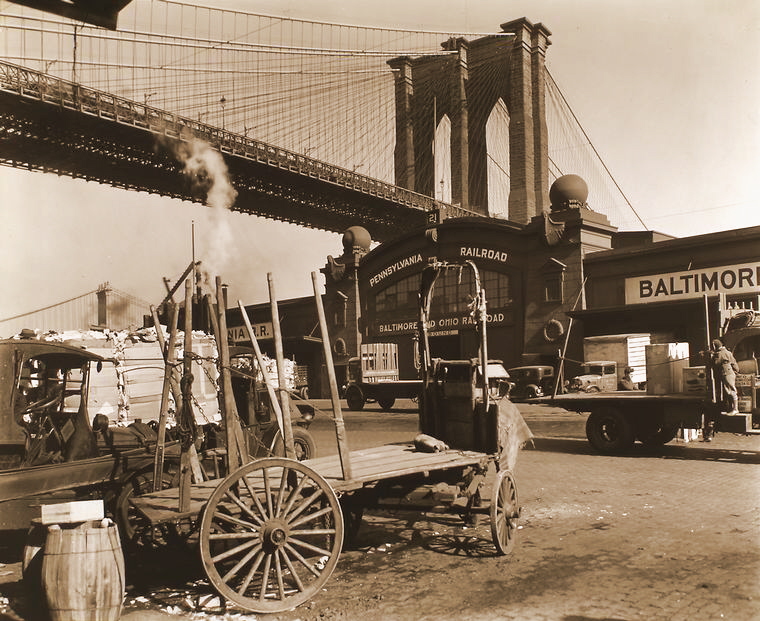
Bridges and Bridge Plates
Freight handling via pier stations was a rather simple but laborsome affair especially in the era prior to mechanized fork lifts. Locomotives, float bridges and yard trackage were not needed, as the freight cars need not be removed from the carfloats. Despite this, pier stations were expeditious and very direct for the transfer of cargo.
Depending on the type of watercraft: covered barge or station carfloat; would dictate the method used for the transfer of freight to and from pier stations, and station / platform carfloats and the pier.
The floors of the pier shed, was ramped down to meet the deck of the pier at regularly spaced intervals, where sliding doors were located.
In the diagrams above, we will be referring to wood plank bridges shown in orange, and steel bridge plates (also called dock plates) and shown in yellow.
The simplest of these wood plank bridge appear to be 6 feet wide and at least 10 to 12 feet long, using 12" x 2" planks. They could be simple in construction or heavily reinforced with side beams.
Bridge plates on the other hand were 3' x 4' plates of 5/8" or 3/4" steel, with multiple punched holes along the edges. The holes were used with prybars to lift or manuever the plate into place when laying flat on a deck.
In either of Diagrams 1, 2 or 3 above; once these bridge plates (in yellow) were in place, and the center platform of the station carfloat was accessable through the red boxcar, any of the other boxcars on the station carfloat were now accessible to the pier shed as represented by the dashed yellow line; and armies of men with hand trucks, dollies or even forklifts could be used to unload / load freight from any of the boxcars on that given carfloat via that center platform (dotted yellow lines).
Unloading priority was given to perishables or expedited freight.
Diagram 1
Upon the arrival of the either a station carfloat with boxcars or a covered barge, the doors of at least one boxcar on the station carfloat or at least one door on the covered barge were positioned directly across from a door on the pier shed. In Diagram 1 above, the two carfloats are moored to the bulkhead and each side of the piershed, and a covered barge is moored to the outshore end of the pier.
In regards to the covered barge, with the pier shed door slid open and the door on the covered barge slid open, a wood plank bridgewas manuevered into position and lashed into place for safety. Men could now begin the process of moving cargo to and fro as seen in image "A" below.
However for a station carfloat, there was one more step to complete: the inwards facing door of the boxcar (shown in red) and facing the center platform was also opened, and a steel bridge plate (also known as a dock plate) (image B below) wheeled into place to bridge the small gap between the boxcar floor and steel deck of the carfloat platform.
Once this bridge plate was in place, men could now bring additional bridge plates to the station carfloat, and open additional boxcar doors and simultaneously carry or wheel cargo to and from any of the boxcars on the carfloat and the piershed.
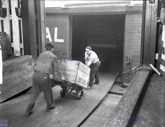 Image "A": wood plank bridge |
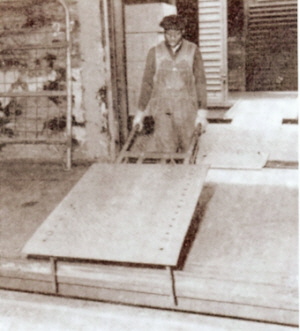 Image B "bridge plate." Note holes along edges. |
Diagram 2
This diagram shows two carfloats moored side by side. This was usually done where a headhouse existed in conjunction with a piershed. The Produce Exchange in lower Manhattan was an example of this.
While the inner most carfloat could be accessed by either a pier shed door or a head house door, the outside carfloat was accessed via the bow ramp, and a wood plank bridge (orange) to a door on the head house. I am sure in times of necessity, a wood plank bridge could have been placed between two carfloats, but I have yet to encounter a photo of this taking place.
Referencing Diagram 2, once the first bridge plate was placed in position, the boxcar in red on the inner carfloat would be unloaded first or at least a pathway cleared between the two boxcar doors. In some cases, an empty or partially empty boxcar was placed in the cut of cars, for expediancy in unloading.
In regard to the outer carfloat, because the bow ramp was being used, it was not necessary that a pathway through a boxcar be cleared first and to use as bridge to the pier; and any or all boxcars were accessable from the start.
Also, in locations of frequent head house usage, even more stoutly constructed wood bridges of various designs with side timbers were used. These heavy bridges were moved in and out of place by block and tackle mounted in the headhouse; and their heavy construction allowed the use of storage battery and gasoline powered "mules" as seen in the image below. Note the net to prevent accidental falls of people or cargo into the water.
This image below also shows the toothed "rack" used to prevent railroad cars from falling off the carfloat, as show in from of the B & O boxcar.
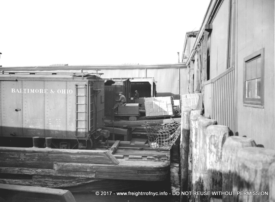 Image C - note heavy timber sided bridge, and safety net.
|
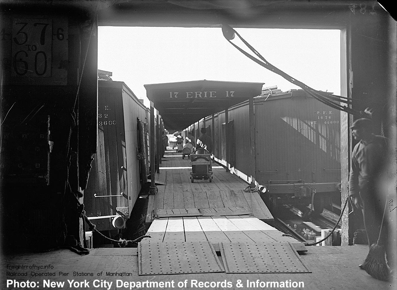 Image D: a wood plank bridge deck and steel bridge plates at front ramp of station carfloat. Note the use of bridge plates at the boxcar doors along left side of platform, as well as the edges of the wood plank bridge to ease the transition. Also note the block and tackle over doorway, which would be used to manuever the plank bridge. |
According to the Joint Plan with Comprehensive Report, in most cases, the head house (or bulkhead shed) was used for the loading of outbound freight, while the piershed (being larger), was used for inbound freight that was unloaded. Consignors were usually given 48 hours "free time" (starting at 7 am the day following the freight's arrival), to come and get their freight. This 48 hour hold time requires a great deal of space, while consignors freight awaits pick up. Therefore the larger piershed was in most cases used for inbound freight.
In some cases, a piershed would be shared between a railroad and steamship line.
.
.
Diagram 3
In some cases, as has been seen on the West Side of Manhattan, a stand alone ramped platform (Image E) was located at the bulkhead and could be bridged to the carfloat. This seems to be a method favored by the New York Central Railroad, as these bulkhead ramps are seen both at the bulkheads at West 34th Street and Twelfth Avenue, as well as the bulkheads along the west driveway of the West 60th Street Yard and in between Piershed. B, D, E and F.
This bulkhead platform allowed direct station carfloat to truck / truck to station carfloat exchange of cargo; without having to go through the pier house.
.
An inland freight station is nothing more than a railroad owned warehouse type structure set away from the piers or offline terminals for storage of freight.
They were used by the railroads to relieve congestion at the waterfront piers and offline terminals. Therefore, a customer could pick up or drop off their shipment at the inland freight station and avoid the hustle and bustle of the pierside location, and the railroad would take care of the transportation to and from the pier and inland freight station.
The inland freight stations were also used for the long term storage of freight before consignees could come an pick up their items. Also, inland freight stations could have served to store "overflow" from pier stations when freight traffic was at it's peak.
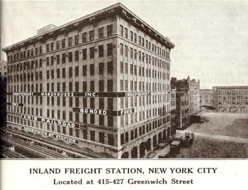
The Erie Railroad had several inland freight stations located in lower Manhattan at Leroy, Greenwich, Watts, and Hubert Streets. These were located one or two short blocks inland from the piers stations on the Hudson River.
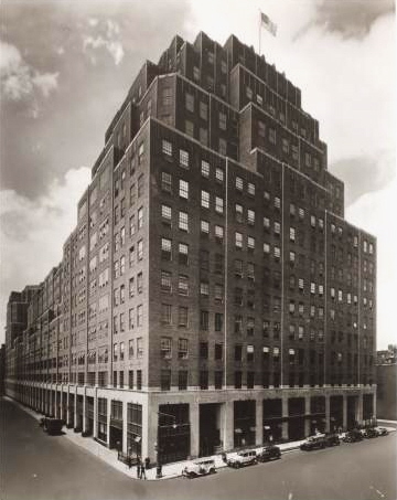
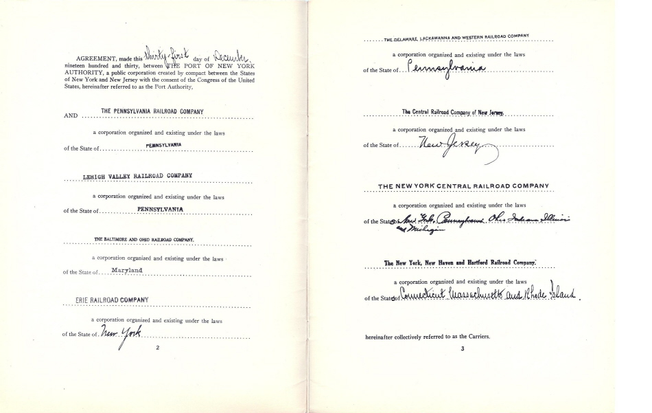
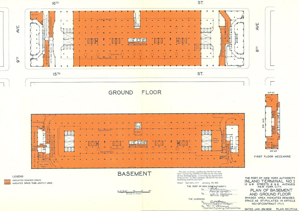
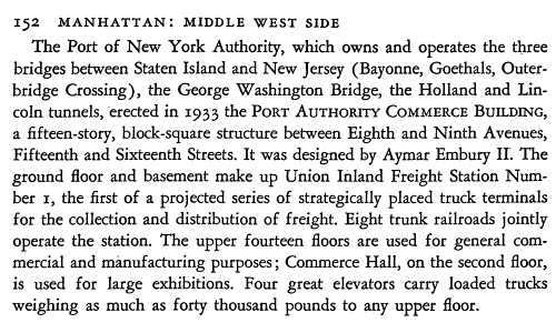
On September 16, 1932; the Port Authority of the City of New York dedicated the Union Inland Freight Station. This facility was also known as the Port of New York Authority, Inland Terminal #1. The Union Inland Freight Terminal was a 16 story building occupying the block between Eighth & Ninth Avenues and West 15th and West 16th Streets and opened for business in 1933.
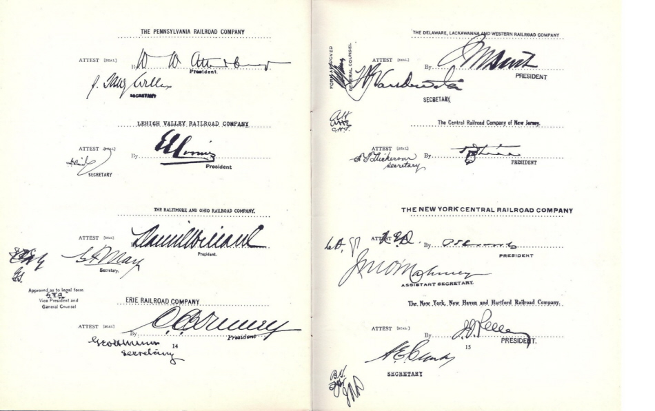
This Union Inland Freight Station was to be occupied by no less than eight trunk line railroads:
| Pennsylvania Lehigh Valley Baltimore & Ohio Erie Delaware, Lackawanna & Western Central Railroad of New Jersey New York Central New York, New Haven & Hartford |
It is understood that the purpose of the Union Inland Freight Station was to provide a convenient and unified location in Midtown Manhattan for the major railroads in the New York Area.
Inbound Freight would arrive from New Jersey via carfloat or lighter at the respective railroad's piers on the Hudson River. The freight was then offloaded and trucked to the Inland Freight Station to await pick up by the consignee / customer.
Outbound Freight would be dropped off by the consignor at the Inland Freight Station at the respective railroads area, and consolidated with other shipments for transfer to the piers. Once at the pier station, the freight would be loaded into freight cars (already on carfloats) for transport to New Jersey where the freight cars would be pulled off the carfloat and subsequently shipped to their various destinations throughout the United States.
In modern "lingo", the Inland Freight Station would now be referred to as a "shipping hub".
Handling the freight twice may appear to be a waste of labor, but considering the limited space at the piers & wharves, congestion of horses & wagons, and later trucks necessitated moving the freight transfer point away from the piers & wharves.
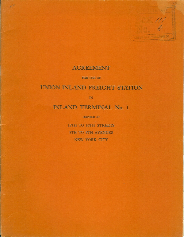
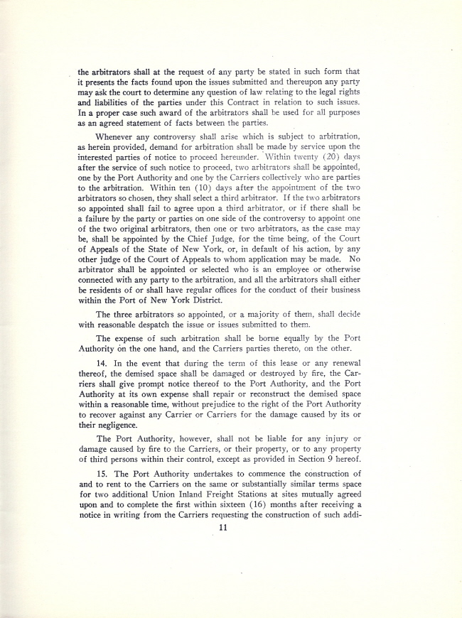
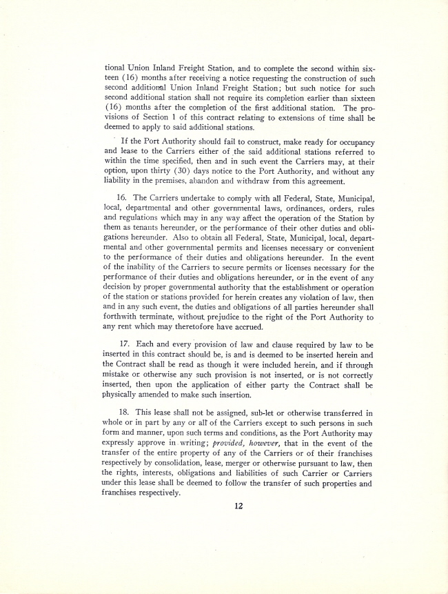
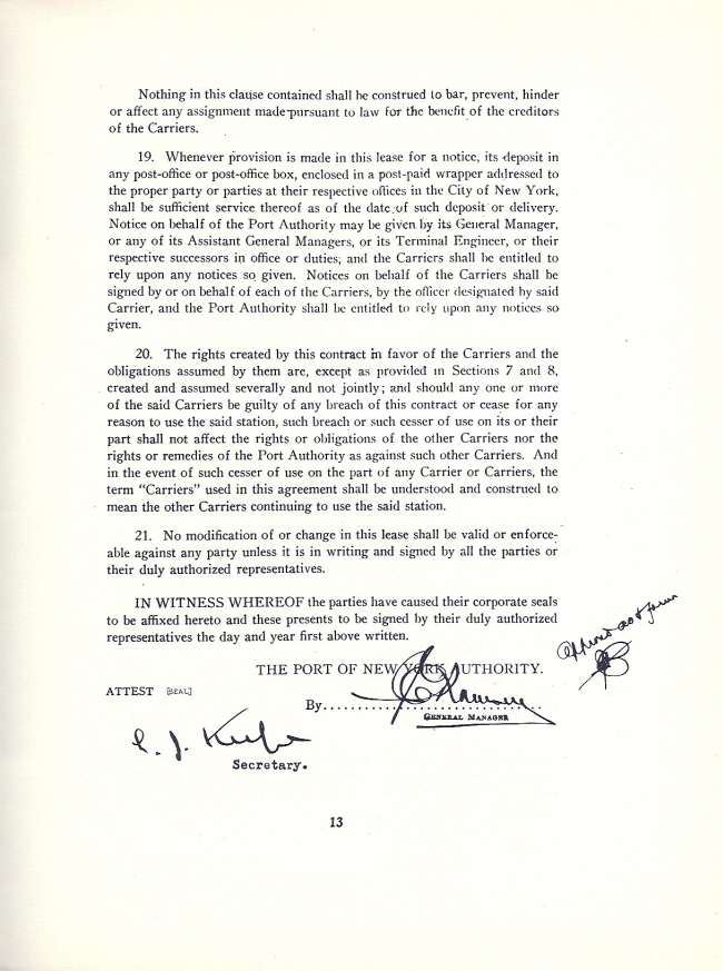
On 08 July 2010, I purchased an original agreement for the use of the Union Inland Freight Station, as issued to the Lehigh Valley Railroad. Upon reading the agreement, I learned that it was originally intended to construct two additional Inland Freight Stations in New York City per the success of the original station. I found evidence that the Port Authority constructed the Union Inland Freight Station #2, also known as the Union Motor Truck Terminal which was located by the Holland Tunnel; and of which appears to have not been utilized by the railroads. I have also not been able to locate evidence of the City actually constructing the third location.
What makes the the Union Inland Freight Station unique, is that instead of being owned by any one individual railroad, it was owned by the City of New York, and they in turn leased space to the railroads. While the Port Authority would maintain the overall structure, heating, ventilation, electrical, and plumbing; the railroads would maintain the freight handling facilities, elevators and all specialty equipment.
The following excerpt is from the "New York City Guide of 1939"
.
What year the structure ceased being the Inland Union Freight Station remains to be discovered. However, I have found reference to it as late as 1947. Referencing the New York Harbor Terminals Map of 1961, shows the location no longer referred to as the Union Inland Freight Terminal, and the location is simply marked Port Authority Building.
.
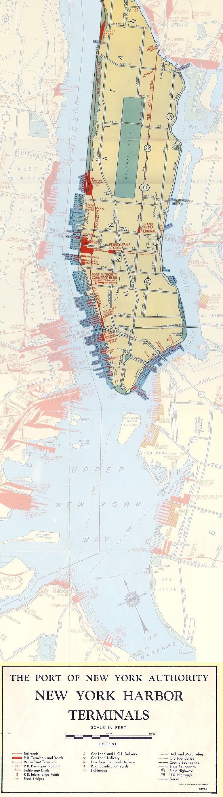
The map below will provide you with a guide as to the locations of the pier stations and freight stations mentioned on this page.
Please keep in mind that this map is from 1943, and some pier stations may have been relinquished or may not have opened yet. Only the piers marked in red were railroad operated, but remember: carfloats and lighters could be spotted at any pier for a customer.
.
Index of Railroad Pier
Stations
Pier Numbering
.
|
Hudson River |
||||||||||||||||||||||||||||||||||||||||||||
| old pier numbering | new pier numbering | |||||||||||||||||||||||||||||||||||||||||||
| foot of street |
1879* (Bromley) |
1885 (Robinson) |
1890-1893 (Robinson) |
1897 (Bromley) |
1902 (Bromley) |
1911 (Bromley) |
1916 (Bromley) |
1920 / 1923 (Bromley) |
1925 (Bromley) |
1935 (PTM) |
1940 (PTM) |
1943 1 (PTM) |
1947 (PTM) |
1952 (PTM) |
1956 (PTM) |
1961 (PTM) |
1965 (PTM) |
1968 (PTM) |
1971 (PRM) |
1977 (PTM) |
links to photos | services | remarks | |||||||||||||||||||||
| W 131 St | MTCo 3 | |||||||||||||||||||||||||||||||||||||||||||
| W 70 St | I | I | NYC&HR | I | NYC&HR | I | NYC&HR | I | NYC | I | NYC | 108 | NYC | I | NYC | I | NYC | I | NYC | I | NYC | I | NYC | I | NYC | I | NYC | I | NYC | I | PC | I | CR | Pier I / 108 | open pier / oversize | |||||||||
| W 68 St | G | NYC&HR | G | NYC&HR | G | NYC&HR | G | NYC&HR | G | NYC | G | NYC | 106 | NYC | G | NYC | G | NYC | G | NYC | G | NYC | G | NYC | Pier G / 106 | FB (3), wb CL 1 | ||||||||||||||||||
| W 66 St | F | NYC&HR | F | NYC&HR | F | NYC&HR | F | NYC&HR | F | NYC | F | NYC | 105 | NYC | F | NYC | F | NYC | F | NYC | F | NYC | F | NYC | Pier F / 105 | eb CL & wb SI 1 | ||||||||||||||||||
| W 65 St | NYC&HR | E | NYC&HR | E | NYC&HR | E | NYC&HR | E | NYC | E | NYC | 104 | NYC | E | NYC | E | NYC | E | NYC | E | NYC | E | NYC | Pier E / 104 | eb LCL1 | |||||||||||||||||||
| W 64 St | NYC&HR | D | NYC&HR | D | NYC&HR | D | NYC&HR | D | NYC | D | NYC | 103 | NYC | D | NYC | D | NYC | D | NYC | D | NYC | D | NYC | Pier D / 103 | eb CL1 | |||||||||||||||||||
| W 63 St | NYC&HR | B | NYC&HR | B | NYC&HR | B | NYC&HR | B | NYC | B | NYC | 102 | NYC | B | NYC | B | NYC | B | NYC | B | NYC | B | NYC | Pier B/ 102 | eb CL1 | |||||||||||||||||||
| W 59 St | NYC&HR (Frt Sta) |
99 | NYC&HR (Frt Sta) |
99 | NYC (Frt Sta) |
99 | NYC (Frt Sta) |
Pier 99 | W 59th St Frt Station |
|||||||||||||||||||||||||||||||||||
| W 49 St | Erie | |||||||||||||||||||||||||||||||||||||||||||
| W 42 St | NYO&W NYWS&B |
BH & 83 | NYC&HR (Frt Sta) |
83 | NYC&HR (Frt Sta) |
83 | NYC (Frt Sta) |
83 | NYC (Frt Sta) |
83 |
NYC (Frt Sta) |
Pier 83 | W 42th St Frt Station |
only one side has openings some WS business |
||||||||||||||||||||||||||||||
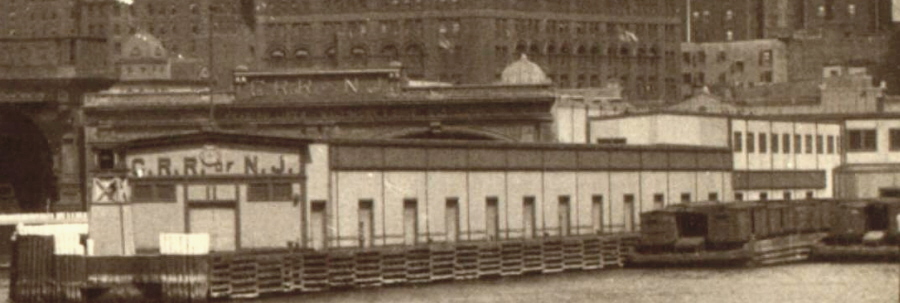
| W 41 St | 71 | CRRNJ | 81 | CRRNJ | 81 | CNJ | 81 | CNJ | Pier 81 | part of pier used for rr purposes also shown as Pier 71 - 1911 |
||||||||||||||||||||||||||||||||||
| W 40 St | 80 3 | CNJ (Frt Sta) |
80 | CNJ (Frt Sta) |
80 | CNJ (Frt Sta) |
80 | CNJ (Frt Sta) |
80 | CNJ (Frt Sta) |
80 | CNJ | Pier 80 | West 40th St CL & LCL |
||||||||||||||||||||||||||||||
| W 39 St | 79 | PRR | 79 | PRR | 79 | PC | 79 | CR | Pier 79 | |||||||||||||||||||||||||||||||||||
| W 38 St | 78 | PRR | 78 | PRR | 78 | PRR | 78 | PRR | 78 | PRR | 78 | PRR | 78 | PRR | 78 | PC | 78 | CR | Pier 78 | FB, CL & LCL | fb on south side | |||||||||||||||||||||||
| W 37 St | 67 | PRR | 67 | PRR | 77 | PRR | 77 | PRR | 77 | PRR | 77 | PRR | 77 | PRR | 77 | PRR | 77 | PRR | 77 | PRR | 77 | PRR | 77 | PRR | Pier 77 | FB, CL & LCL | fb on north side | |||||||||||||||||
| W 36 St | 66 | WS | 76 | NYC&HR | 76 | NYC | 76 | NYC | 76 | NYC | Pier 76 | trackage | ||||||||||||||||||||||||||||||||
| (65.5) BH |
PRR | no pier, just freight shed |
||||||||||||||||||||||||||||||||||||||||||
| W 33 St | 63 | NYC&HR | 63 | NYC&HR | 73 | NYC&HR | 73 | NYC | 73 | NYC | Pier 73 | fb on north side | ||||||||||||||||||||||||||||||||
| W 32 St | 62 | NYC&HR | 62 | NYC&HR | 62 | NYC&HR | 72 | NYC&HR | 72 | NYC | 72 | NYC | Pier 72 | FB, CL & LCL | fb on south side | |||||||||||||||||||||||||||||
| W 31 St | 61 | NYC&HR | 61 | NYC&HR | 61 | NYC&HR | 71 | NYC&HR | 71 | NYC | 71 | NYC | Pier 71 | |||||||||||||||||||||||||||||||
| W 28.5 St | 58 | DL&W | 58 | DL&W | 58 | DL&W | 68 | DL&W | 68 | DL&W | 68 | DL&W | 68 | DL&W | 68 | DL&W | 68 | DL&W | 68 | DL&W | 68 | DL&W | 68 | DL&W | 68 | EL | 68 | EL | 68 | EL | Pier 68 | FB, CL & LCL | ||||||||||||
| W 27.5 St | 67 | Erie | 67 | Erie | 67 | Erie | 67 | Erie | 67 | Erie | 67 | Erie | 67 | EL | 67 | EL | 68 | CS | Pier 67 | |||||||||||||||||||||||||
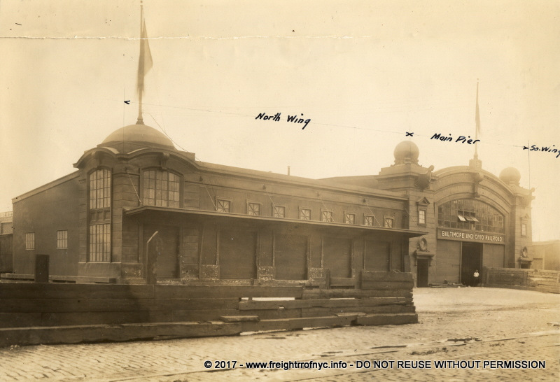
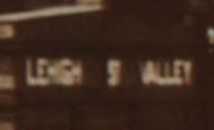
| W 26.5 St | 56 | B&O | 56 | LV | 66 | LV | 66 | LV | 66 | LV | 66 | LV | 66 | LV | 66 | LV | 66 | LV | 66 | LV | 66 | B&O | 66 | B&O | 66 | B&O | 66 | B&O | 66 | CS | Pier 66 | FB, CL & LCL | hay storage outer half only one side has openings |
|||||||||||
| W 23 St | BH | NLE&W | 63 | B&O | 63 | B&O | 63 | B&O | 63 | CS | ||||||||||||||||||||||||||||||||||
| W 15 St | 4 | CNJ | 4 | CNJ | FB, CL & LCL | gone by 1909 | ||||||||||||||||||||||||||||||||||||||
| Gansevoort St | 56 | LV | 52 | PRR | 52 | PRR LIRR |
52 | B&O | 52 | B&O | 52 | B&O | 52 | B&O | Pier 52 | CL | noted on 1956 map | |||||||||||||||||||||||||||
| W 12th St | 51 | B&O | 50 | CR | CL | |||||||||||||||||||||||||||||||||||||||
| 50 | PRR | 50 | PRR LIRR |
50 | PRR | 50 | PRR | 50 | PRR | 50 | PRR | 50 | PRR | 50 | PC | 50 | CR | Pier 50 | CL & LCL | |||||||||||||||||||||||||
| Bank St | 49 | PRR | 49 | PRR LIRR |
49 | PRR | 49 | PRR | 49 | PRR | 49 | PRR | CL | |||||||||||||||||||||||||||||||
| W 11th St | 48 | Erie | 48 | Erie | 48 | Erie | 48 | Erie | 48 | Erie | 48 | EL | 48 | EL | 48 | EL | 48 | EL | Pier 48 | CL & LCL | possible Southern Pacific pier | |||||||||||||||||||||||
| Charles St | 46 | CNJ | 46 | CNJ | 46 | CNJ | 46 | LV | 46 | LV | 46 | LV | 46 | LV | Pier 46 | |||||||||||||||||||||||||||||
| W 10th St | 45 | CNJ B&O | ||||||||||||||||||||||||||||||||||||||||||
| Christopher St | 44 | LV | 44 | LV | Pier 44 | |||||||||||||||||||||||||||||||||||||||
| Barrow St | 43 | PRR | ||||||||||||||||||||||||||||||||||||||||||
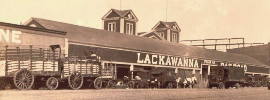
| LeRoy St | 48 | CNJ | 41 | DL&W | 41 | DL&W | 41 | DL&W | 41 | DL&W | 41 | DL&W | 41 | DL&W | 41 | DL&W | 41 | DL&W | 41 | DL&W | 41 | DL&W | 41 | DL&W | Pier 41 | CL & LCL | awning shed | |||||||||||||||||
| Clarkson St | 40 | PRR | 40 | PRR | 40 | B&O | Pier 40 | CL | noted on 1956 map | |||||||||||||||||||||||||||||||||||
| W. Houston St | 39 | CNJ, 2 WS, Erie | 39 | CNJ | 39 | CNJ | 39 | CNJ | 39 | B&O | 39 | B&O | 39 | CNJ | Pier 39 | CL & LCL | Erie leases space from CRRNJ | |||||||||||||||||||||||||||
| King St | 38 | LV | 38 | LV | 38 | LV | 38 | LV | 38 | LV | 38 | LV | Pier 38 | CL | part of pier used by CRRNJ | |||||||||||||||||||||||||||||
| Canal St | 34 | LV | 34 | LV / CV | 34 | LV | 34 | LV | Pier 34 | |||||||||||||||||||||||||||||||||||
| Hoboken St | BH. | CNJ | ||||||||||||||||||||||||||||||||||||||||||
| Debrosses / Watts |
31 | NYC&HR | 31 | NYC&HR | 31 | NYC | 31 | NYC | only one side has openings some WS business |
|||||||||||||||||||||||||||||||||||
| 30 | PRR | 30 | PRR LIRR |
30 | PRR LIRR | 30 | PRR | 30 | PRR | 30 | PRR | 28Pier 30 | LCL | |||||||||||||||||||||||||||||||
| Vestry St | 29 | PRR | 29 | PRR | 29 | PRR | 29 | PRR | 28 | PRR | 29 | PRR | 29 | PRR | 29 | PRR | 29 | PRR | 29 | PRR | 29 | PRR | 29 | PRR | 29 | PRR | 29 | PRR | 29 | PRR | 29 | PRR | 29? | ? | 29 | ? | Pier 29 Produce Term'l |
heated pier shed general freight busy terminal |
||||||
| Laight St | 28 | PRR | 28 | PRR | 28 | PRR | 28 | PRR | 28 | PRR | 28 | PRR | 28 | PRR | 28 | PRR | 28 | PRR | 28 | PRR | 28 | PRR | 28 | PRR | 28 | PRR | 28 | PRR | 28 | PRR | 28 | PRR | 28 | ? | 28 | ? | CL & LCL | |||||||
| Hubert St | 38 | PRR | 27 | PRR | 27 | PRR | 27 | PRR | 27 | PRR | 27 | PRR | 27 | PRR | 27 | PRR | 27 | PRR | 27 | PRR | 27 | PRR | 27 | PRR | 27 | PRR | 27 | PRR | 27 | Erie | 27 | EL | 27 | EL | CL & LCL | |||||||||
| Harrison / Franklin St | 23 | NYWS&B | 23 | WS | 23 | WS | 23 | WS / NYOW | 23 | WS | 23 | WS | 23 | B&O | 23 | B&O | 23 | B&O | 23 | CNJ | 23 | CNJ | 23 | CNJ | Pier 23 | CL & LCL | ||||||||||||||||||
| Jay St | 22 | B&O | 22 | B&O | 22 | B&O | 22 | B&O | 22 | B&O | 22 | B&O | 22 | B&O | 22 | B&O | 22 | B&O | 22 | B&O | 22 | B&O | 22 | B&O | 22 | B&O | 22 | B&O? | Pier 22 | |||||||||||||||
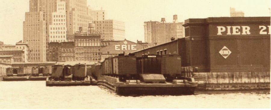
| Pier 21 | ||||||||||||||||||||||||||||||||||||||||||||
| Duane St | 31 | NYLE&W | 21 | NYLE&W | 21 | NYLE&W | 21 | NYLE&W | 21 | NYLE&W | 21 | Erie | 21 | Erie | 21 | Erie | 21 | Erie | 21 | Erie | 21 | Erie | 21 | Erie | 21 | Erie | 21 | Erie | 21 | B&O | 21 | B&O | 21 | EL | 21 | EL | Pier 21 | CL & LCL | ||||||
| Chambers St | 20 | NYLE&W | 20 | NYLE&W | 20 | NYLE&W | 20 | NYLE&W | 20 | Erie | 20 | Erie | 20 | Erie | 20 | Erie | 20 | Erie | 20 | Erie | 20 | Erie | 20 | Erie | 20 | Erie | 20 | B&O | 20 | B&O | 20 | EL | Pier 20 | Fruit / Perishables | heated, only one side has openings, | |||||||||
| 19 | Erie | 19 | Erie | 19 | Erie | 19 | EL | |||||||||||||||||||||||||||||||||||||
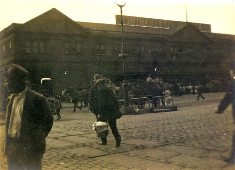
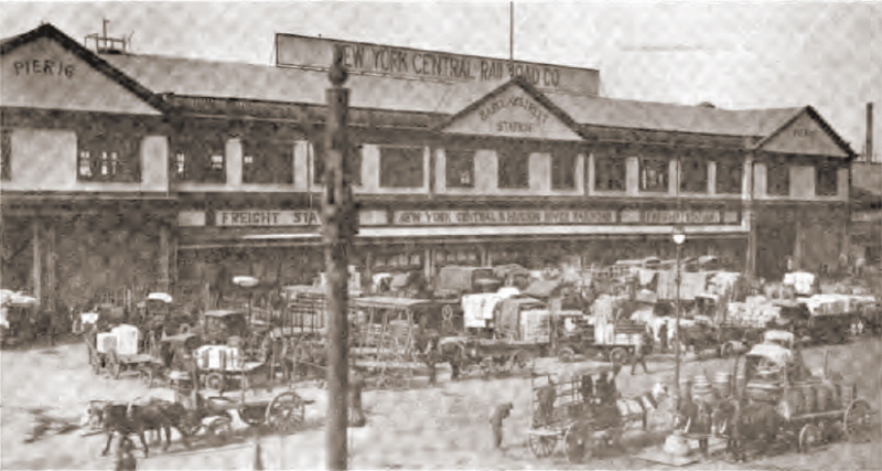
| Park Pl | 27 | NYC&HR | Old 27 | NYC&HR | 17 | NYC&HR | 17 | NYC&HR | 17 | NYC&HR | 17 | NYC | 17 | NYC | 17 | NYC | 17 | NYC | 17 | NYC | 17 | NYC | 17 | NYC | 17 | NYC | Pier 17 | |||||||||||||||||
| Barclay St | 25 | NYC&HR | 16 | NYC&HR | 25 | NYC&HR | Old 25 | NYC&HR | 16 | NYC&HR | 16 | NYC&HR | 16 | NYC&HR | 16 | NYC | 16 | NYC | 16 | NYC | 16 | NYC | 16 | NYO&W NYC |
16 | NYO&W NYC |
16 | NYO&W | 16 | NYO&W | Pier 16 | |||||||||||||
| Dey / Cortlandt St | 19 | DL&W | 12 | DL&W | DL&W | DL&W | 13 | DL&W | 13 | DL&W | 13 | DL&W | 13 | DL&W | 13 | DL&W | 13 | DL&W | 13 | DL&W | 13 | DL&W | 13 | DL&W | 13 | DL&W | Pier 13 | |||||||||||||||||
| Liberty St | PRR | |||||||||||||||||||||||||||||||||||||||||||
| Cedar St | 14 | CNJ | CNJ | 14 | CNJ | |||||||||||||||||||||||||||||||||||||||
| - | 13 | CNJ | 11 |
CNJ | 13 | CNJ | CNJ | 13 | CNJ | 11 | CNJ | 11 | CNJ | 11 | CNJ | 11 | CNJ | Pier 11 | ||||||||||||||||||||||||||
| Albany St | 12 | CNJ | 10 | CNJ | 12 | CNJ | CNJ | 12 | CNJ | 10 | CNJ | 10 | CNJ | 10 | CNJ | 10 | CNJ | 10 | CNJ | 10 | CNJ | 10 | CNJ | 10 | CNJ | |||||||||||||||||||
| 9 | CNJ | 9 | CNJ | |||||||||||||||||||||||||||||||||||||||||
| Rector St | 8 | CNJ | 8 | NJS | 8 | NJS | 8 | CNJ | 8 | CNJ | 8 | CNJ | 8 | CNJ | 8 | LV | 8 | LV | 8 | LV | 8 | LV | 8 | LV | 8 | LV | 8 | LV | 8 | LV | Pier 8 | |||||||||||||
| 7 | B&O | 7 | B&O | 7 | B&O | 7 | EL | Pier 7 | ||||||||||||||||||||||||||||||||||||
| 6 | PRR | 6 | PRR | 6 | PRR | Pier 6 | ||||||||||||||||||||||||||||||||||||||
| Morris St | 5 | PRR | 5 | PRR | 5 | PRR | 5 | PRR | 5 | PRR | 5 | PRR | 5 | PRR | 5 | PRR | 5 | PRR | Pier 5 | |||||||||||||||||||||||||
| Morris St | 4 | PRR | 4 | PRR | 4 | PRR | 4 | PRR | 4 | PRR | 4 | PRR | 4 | PRR | Pier 4 | |||||||||||||||||||||||||||||
| 3 | LV | 3 | LV | 3 | LV | 3 | LV | 3 | LV | Pier 3 | ||||||||||||||||||||||||||||||||||
| 2 | LV | 2 | LV | 2 | LV | 2 | LV | 2 | LV | 2 | LV | Pier 2 | CL & LCL | operated by CRRNJ in 1914 | ||||||||||||||||||||||||||||||
| Battery Pl | 1 | PRR | 1 | PRR | 1 | PRR | 1 | PRR | 1 | PRR | 1 | PRR | 2 | PRR | 2 | PRR | Pier 1 | |||||||||||||||||||||||||||
| Battery Pl | B | B&O | Pier B | |||||||||||||||||||||||||||||||||||||||||
Notes:
* = incomplete atlas in NYPL archives (volumes missing)
1 = correlates to 1942 ACoE Port & Terminal Facilites, Part 2
2 = inbound only
3 = MTCo = Manhattan Terminal Co.: Joint Company for B&O, LV, Erie, CNJ
When a street is listed as 26.5, this denotes the pier is
located mid-block between two streets, and not physically at the foot of
a street.
BH =
unnumbered Bulkhead House or Freight Shed, not a pier;
B&O = Baltimore
& Ohio; CNJ = Central RR of New Jersey;
CR = ConRail; CS = Chessie System; CV = Central Vermont; DL&W =
Delaware, Lackawanna & Western; Erie = Erie; EL
= Erie Lackawanna;
LV =
Lehigh Valley; NJS = New Jersey Southern;
NYLE&W = New York, Lake Erie & Western; NYO&W
= New York, Ontario & Western; NYC = New York Central;
NYC&HR = New York Central & Hudson River;
NYWS&B
= New York West Shore & Buffalo; PRR = Pennsylvania; WS= West Shore
| East River | |||||||||
| railroad | new pier # | old pier # | location | services | dimensions | remarks | |||
| PRR | E 125th Street | CL & LCL | at confluence of Harlem River, gone by 1956 | ||||||
| LV | E 124th Street | CL & LCL | at confluence of Harlem River, gone by 1956 | ||||||
| LV | Pier 57 - E 48th St | FtHs, CL & LCL, Stock Yards | |||||||
| NYNH&H | Pier 70 - E 22nd St | no bulkhead platform | |||||||
| LV | Pier 44 - Jackson St | CL & LCL | 194' x 69' | ||||||
| NYNH&H | Pier 42 - Gouvenours Slip Pier 41 - Gouvenours Slip Pier 40 - Gouvenours Slip Pier 39 - Montgomery St Pier 38 - Montgomery St Pier 37 - Clinton St |
LCL, Lighterage | |||||||
| NYC | Pier 35 - Jefferrson St | CL & LCL | open bulkhead | ||||||
| NYO&W / NYC | Pier 34 - Rutgers Slip | CL & LCL | |||||||
| NYNH&H | Pier 31 - Pike Slip | no bulkhead platforms | |||||||
| CV | Pier 29 - Market Slip | ||||||||
| DL&W | Pier 26 - Catherine St | CL & LCL | 422' x 45' | shared w/ Atlantic Fruit | |||||
| PRR | Pier 25 - Oliver St | 300' x 40' | joint station of LIRR/ PRR | ||||||
| LIRR | Pier 22 - James Slip | 236' x 50' | joint station of LIRR/ PRR | ||||||
| B&O & PRR | Pier 21 - Dover St | CL & LCL | double deck pier | ||||||
| Erie / B&O? | Pier 7 - Coenties Slip | CL & LCL | 571' x 80' | ||||||
| NYC | Pier 4 - Broad St | ||||||||
|
Inland Freight Stations |
|||||||||
| B&O, CRRNJ, DL&W, Erie, LV, NYC, NYNH&H, PRR |
Ninth Avenue & West 16th Street |
FtHs, CL & LCL | "Union Inland Freight Station" | ||||||
| Erie | Leroy Street | FtHs, CL & LCL | |||||||
| Erie | Watts St | FtHs, CL & LCL | |||||||
| Erie | Greenwich St | FtHs, CL & LCL | |||||||
| Erie | Hubert St | FtHs, CL & LCL | |||||||
Legend
|
FB |
= |
float bridge |
|
CL |
= |
car load delivery only |
|
LCL |
= |
less than car load delivery only |
|
CL & LCL |
= |
car load & less than car load delivery |
|
FtHs |
= |
no pier - inland freighthouse only |
.
..
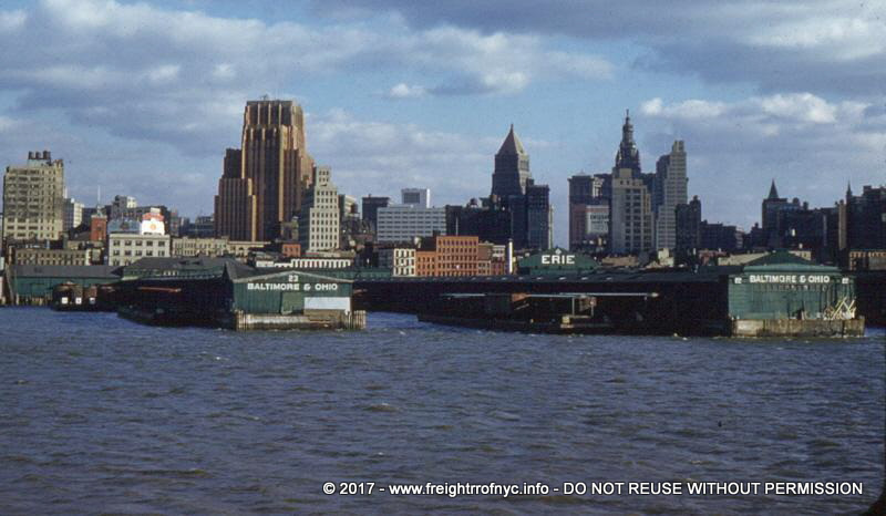
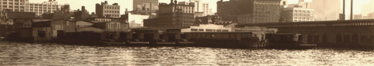
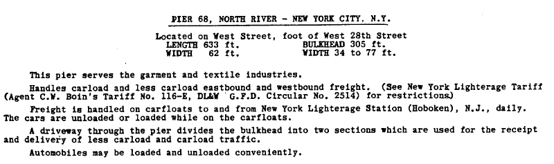
HUDSON RIVER A/K/A NORTH RIVER
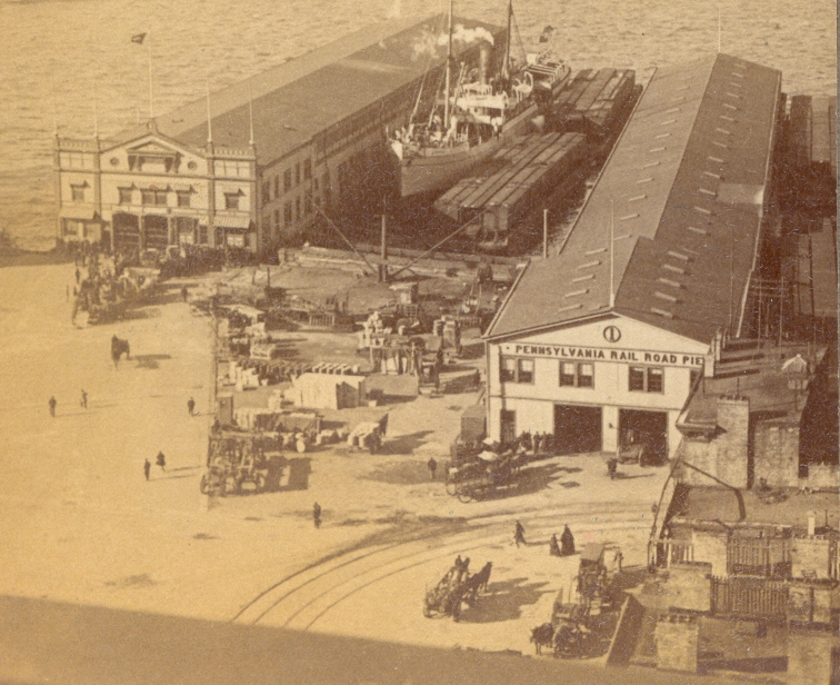
PIER 1
- PIER STATION
Hudson River, Manhattan
(PENNSYLVANIA RAILROAD)
.

|
|
.
.
| RETURN TO MAIN INDEX |
..
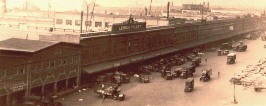
PIER 8
- RECTOR STREET PIER
STATION
Hudson River, Manhattan
(LEHIGH VALLEY RAILROAD)
.
|
|
|
. . |
|
|
.
.
| RETURN TO MAIN INDEX |
..
PIER
11 - CEDAR STREET PIER
STATION
Hudson River, Manhattan
(CENTRAL RAILROAD OF NEW JERSEY)
.
.
Central Railroad of New Jersey - Cedar Street Freight
Station / Pier 11 - ca. 1932
E. Galloway photo
NYPL Digital
Archives
added 02 July 2009
.
.
| RETURN TO MAIN INDEX |
..
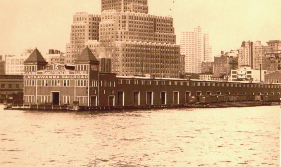
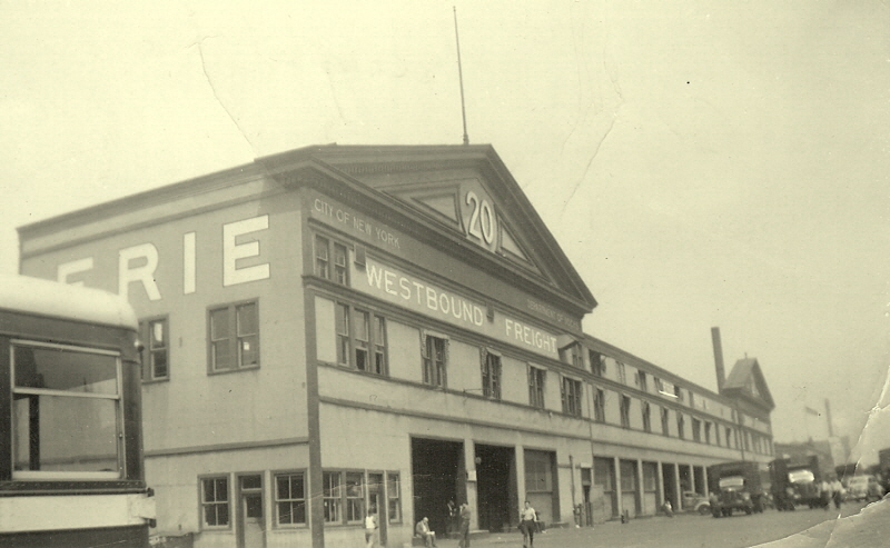
PIER 13 -
CORTLANDT STREET PIER
STATIO
Hudson River, Manhattan
(DELAWARE, LACKAWANNA & WESTERN RAILROAD)
DL & W Pier Station S
...
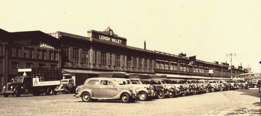
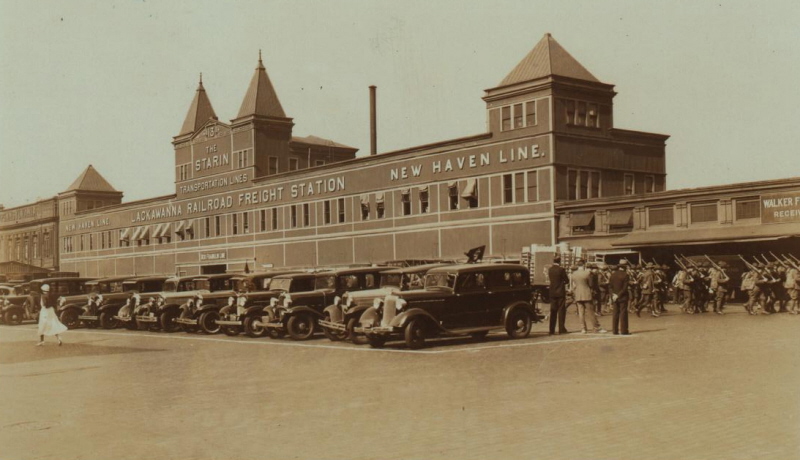
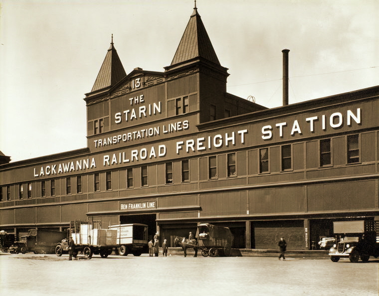
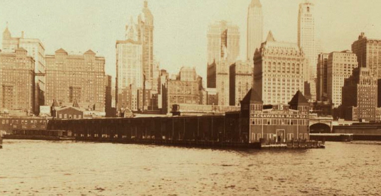
The Delaware, Lackawanna & Western Freight Station located on Pier 13 (Hudson River) was located at the foot of Cortlandt Street.
According to Joint Report with Comprehensive Plan & Recommendations, 1920, published by the New York New Jersey Port & Harbor Development Commission; Pier 13 dimensions were 882' x 100'.
The following is an excerpt from the Delaware, Lackawanna & Western RR 1952 Directory of Industries & Facilities:
This Freight Station would share space with the Starin Transportation, Ben Franklin and New Haven shipping lines.
|
|
| .
. |
|
|
| .
. |
|
|
| .
. |
|
|
.
.
| RETURN TO MAIN INDEX |
..
PIER 16 -
BARCLAY STREET PIER
STATION
Hudson River, Manhattan
(NEW YORK CENTRAL RAILROAD)
.
.
|
|
| .
. |
|
|
.
.
| RETURN TO MAIN INDEX |
..
PIER
20 - CHAMBERS STREET PIER
STATION
Hudson River, Manhattan
(ERIE RAILROAD)
.
.
Erie Railroad - Chambers Street Freight Station / Pier
20 - 1942
Homer H. Poss, Jr. photo
(Mr.
Poss was sightseeing in New York City prior to disembarkation for overseas
duty during when he took this image.
His daughter, Sherry Fletcher; contacted me and presented this image (along
with a photo of the DL&W Ferry "Ithaca") as gifts.
authors collection
added 23 November
2009
.
.
| RETURN TO MAIN INDEX |
..
PIER
21 - DUANE STREET PIER
STATION
Hudson River, Manhattan
(ERIE RAILROAD)
.
.
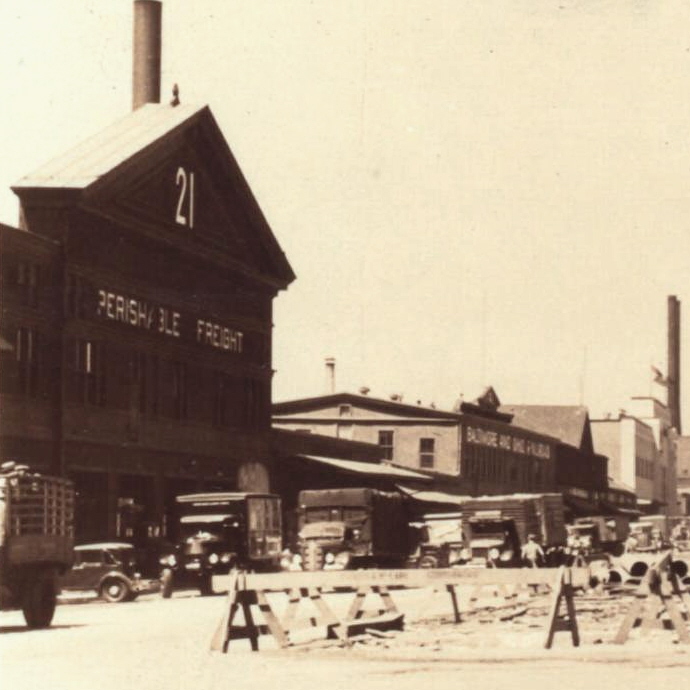
Erie Railroad - Duane Street Freight Station / Pier
21 - July 8, 1937
(with Baltimore & Ohio Jay Street / Pier 22 in
background)
P. L. Sperr photo
NYPL Digital Archives
added 02 July
2009
.
.
Erie Railroad - Duane Street Freight Station / Pier
21 - August 31, 1926
P. L. Sperr photo
NYPL Digital Archives
added 03 July
2009
.
.
Erie Railroad - Duane Street Freight Station / Pier
21 - July 12, 1931
P. L. Sperr photo
NYPL Digital Archives
added 03 July
2009
.
.
| RETURN TO MAIN INDEX |
..
PIER
20 / 21 - DUANE STREET PIER
STATION
Hudson River, Manhattan
(BALTIMORE & OHIO RAILROAD)
.


Baltimore & Ohio Railroad - Duane Street Freight
Station / Pier 21 (left) and Pier 20 (right) - ca. 1950
unknown photographer
E. Bommer collection
added 27 December 2011
.
.
| RETURN TO MAIN INDEX |
..
PIER 22 -
JAY STREET PIER
STATION
Hudson River, Manhattan
(BALTIMORE & OHIO RAILROAD)
.
.
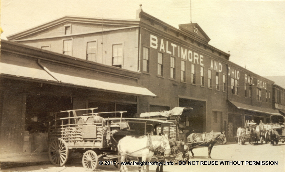
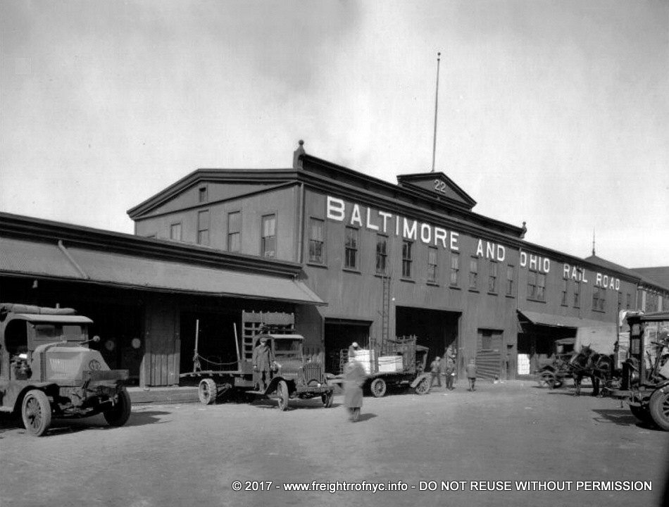
Baltimore & Ohio Railroad - Jay Street Freight
Station / Pier 22 - unknown date
Photo taken by Interstate Commerce Commission and Baltimore & Ohio Railroad
Inventory Crew between 1916 and 1920.
image courtesy of Joseph De May, Kew Gardens,
NY
added 19 June
2010
.
.
.
Baltimore & Ohio Railroad - Jay Street Freight
Station / Pier 22 - ca. 1920's
E. Bommer collection
added 28 December
2011
.
.
Baltimore & Ohio Railroad - Jay Street Freight
Station / Pier 22 - ca. 1920's
Note the wood bridge to carfloat platform and safety net.
E. Bommer collection
added 28 December
2011
.
.
Baltimore & Ohio Railroad - Jay Street Freight
Station / Pier 22 - July 8, 1937
P. L. Sperr photo
NYPL Digital Archives
added 02 July 2009
.
.
| RETURN TO MAIN INDEX |
..
PIER 23 -
HARRISON STREET PIER
STATION
Hudson River, Manhattan
(BALTIMORE &
OHIO
RAILROAD)
(Pier 23 was formerly New York Central)
.
.
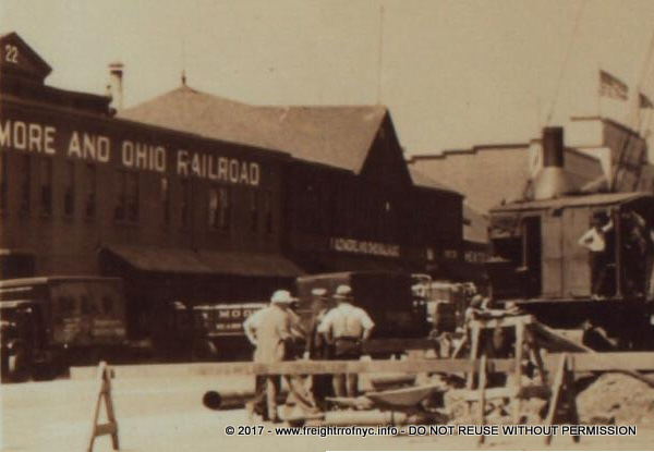
Baltimore & Ohio Railroad - Harrison Street Freight
Station / Pier 23 & Jay Street Freight Station / Pier 22 - unknown
date
Erie RR Pier 21 / Duane Street facade showing in background above Pier 22
roof.
G. Hockaday photographer
L. Kilian collection
authors collection
added 26 Sept
2009
.
.
| RETURN TO MAIN INDEX |
..
PIER 29
- VESTRY STREET PIER STATION
(PRODUCE
MARKET)
Hudson River, Manhattan
(PENNSYLVANIA RAILROAD)
E RR / EL / Bronx Terminal / Harlem River / East 149th Street Terminal
Pennsylvania Railroad Vestry Street Produce Market
/ Pier 29 - October 24, 1934
(Canal Street left, Pier 29 right)
P. L. Sperr photo
NYPL Digital Archives
added 02 July 2009
.
.
Pennsylvania Railroad Vestry Street Produce Market / Pier 30 (left) Pier
29 (right) - June 30, 1932
Aerial Explorations, Inc.
NYPL Digital Archives
added 03 July 2009
.
.
| RETURN TO MAIN INDEX |
..
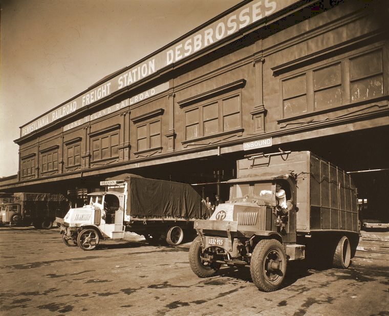
PIER 30 -
DEBROSSES STREET PIER
STATION
Hudson River, Manhattan
(PENNSYLVANIA RAILROAD & LONG ISLAND RAIL ROAD)
E RR / EL / Bronx Terminal / Harlem River / East 149th Street Terminal
|
. .
. .
|
.
.
| RETURN TO MAIN INDEX |
..
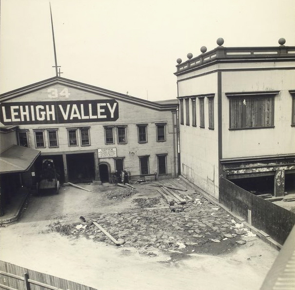
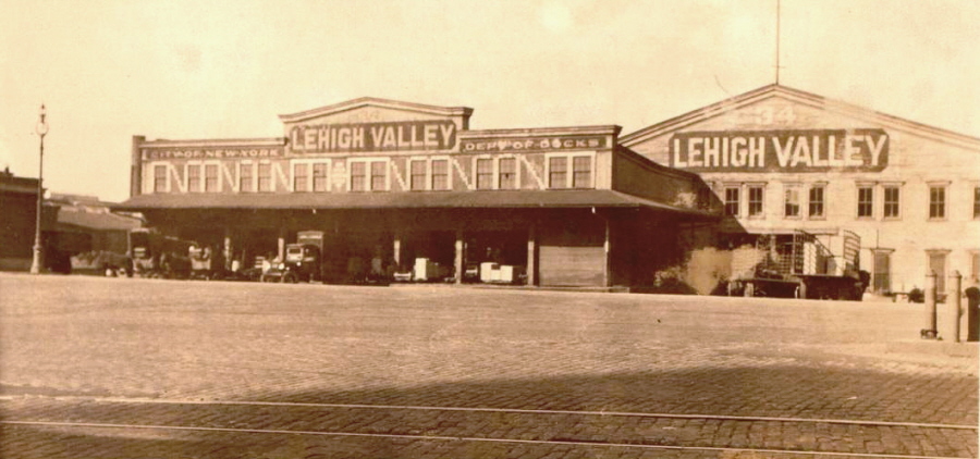
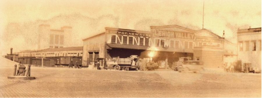
PIER 34
- CANAL STREET PIER
STATION
Hudson River, Manhattan
(LEHIGH VALLEY RAILROAD)
E RR / EL / Bronx Terminal / Harlem River / East 149th Street Terminal
|
|
| .
. |
|
|
| .
. |
|
|
| .
. |
|
|
.
.
| RETURN TO MAIN INDEX |
..
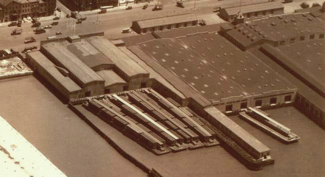
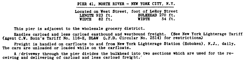
PIER 41
- LEROY STREET PIER
STATION
Hudson River, Manhattan
(DELAWARE, LACKAWANNA & WESTERN RAILROAD)
E RR / EL / Bronx Terminal / Harlem River / East 149th Street Terminal
The following is an excerpt from the Delaware, Lackawanna & Western RR 1952 Directory of Industries & Facilities:
|
|
.
.
| RETURN TO MAIN INDEX |
..
PIER 48 -
WEST 11TH STREET PIER
STATION
Hudson River, Manhattan
(ERIE RAILROAD)
DL & W Pier Station S
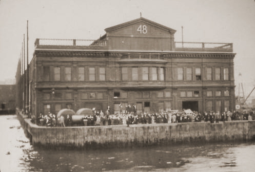
Erie Railroad Pier 48 / West 11th Street Pier Station
- unknown date
(possibly Southern Pacific Company?)
image courtesy of Joseph De May, Kew Gardens,
NY
added 09 June 2010
.
.
| RETURN TO MAIN INDEX |
..
PIER 52 -
WEST 12TH STREET PIER
STATION
Hudson River, Manhattan
(BALTIMORE & OHIO)
DL & W Pier Station S

Baltimore & Ohio Railroad Pier 48 / West 12th Street
Pier Station - September 1972
T. Flagg
photo
added 13 January 2012
.
.
| RETURN TO MAIN INDEX |
..
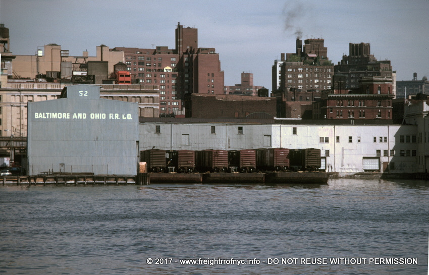
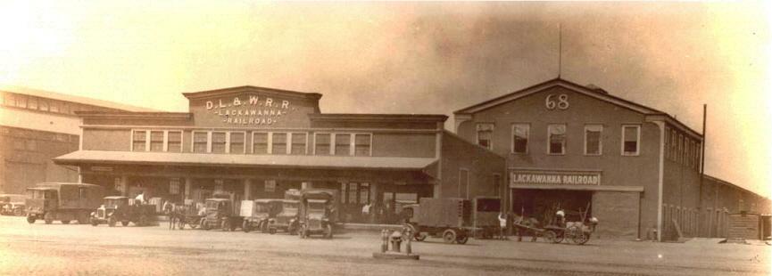
PIER 68 -
WEST 28TH STREET PIER
STATION
Hudson River, Manhattan
(DELAWARE, LACKAWANNA & WESTERN RAILROAD)
DL & W Pier Station S
The Delaware, Lackawanna & Western Freight Station located on Pier 68 (Hudson River) was located at the foot of West 28th Street.
According to Joint Report with Comprehensive Plan & Recommendations, 1920, published by the New York New Jersey Port & Harbor Development Commission; Pier 68 dimensions were 621' x 50', with a track down middle of pier.
The following is an excerpt from the Delaware, Lackawanna & Western RR 1952 Directory of Industries & Facilities:
Even though this pier station would be flanked by Lehigh Valley and Erie Railroads, it would not be associated with a rail yard until 1960, when the Erie and the Delaware Lackawanna & Western Railroads merged, forming the Erie - Lackawanna Railroad.
Delaware, Lackawanna & Western Railroad Freight
Station / Pier 68 - May 29, 1931
P. L. Sperr photo
NYPL Digital Archives
added 02 July 2009
.
.
| RETURN TO MAIN INDEX |
..
PIER
72 & 73 - WEST 32ND & WEST 33RD
STREET PIER
STATION
Hudson River, Manhattan
(NEW YORK CENTRAL RAILROAD)
DL & W Pier Station S
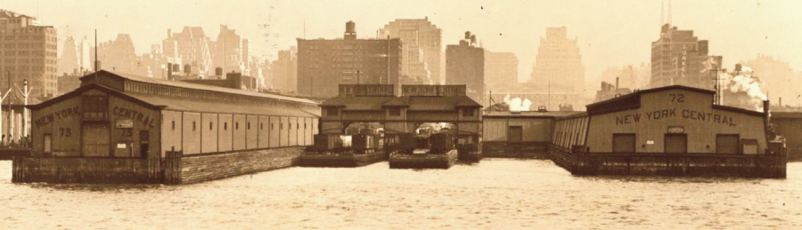
New York Central Freight Station Pier 73 (left), float
bridges (center), Pier 72 (right) - ca. 1929
(looking east)
unknown photographer
NYPL Digital Archives
added 02 July 2009
.
.
| RETURN TO MAIN INDEX |
..
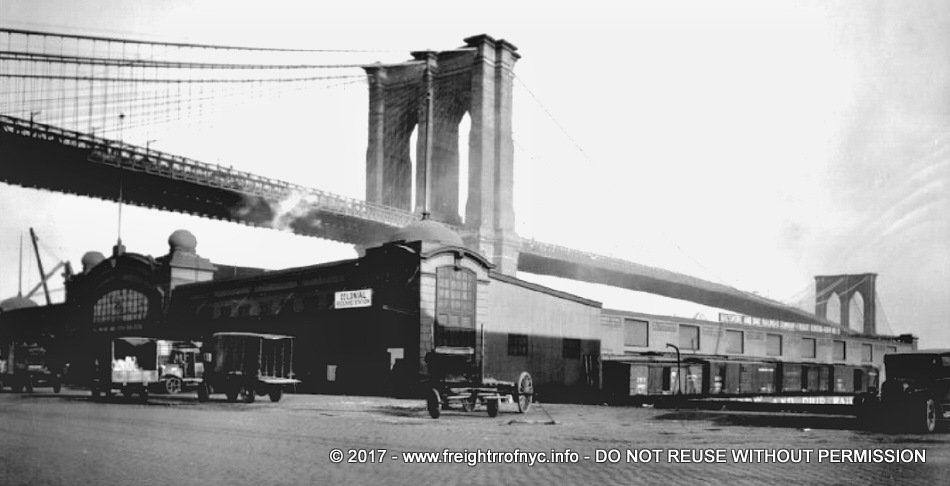
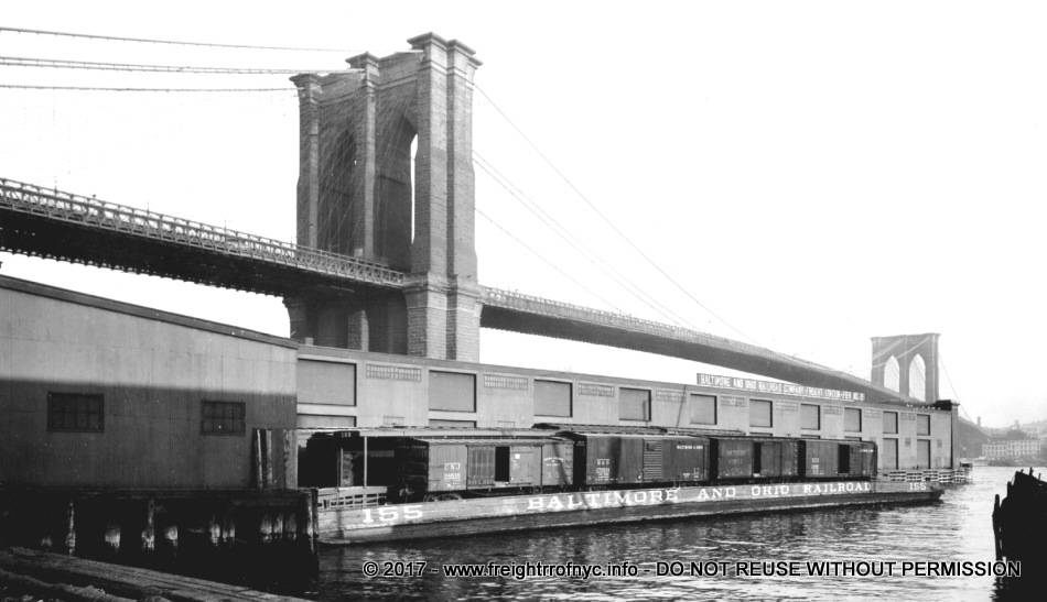
EAST RIVER
PIER 7 -
COENTIES SLIP PIER
STATION
East River, Manhattan
(ERIE RAILROAD & BALTIMORE & OHIO? RAILROAD)
E RR / EL / Bronx Terminal / Harlem River / East 149th Street Terminal
Erie Railroad (w/Baltimore & Ohio? Railroad) Coenties
Slip / Pier 7 Freight Station - unknown date
courtesy of J. DeMay
collection
added 26 June 2010
.
.
| RETURN TO MAIN INDEX |
..
PIER 21 -
DOVER STREET PIER
STATION
East River, Manhattan
(BALTIMORE & OHIO RAILROAD & PENNSYLVANIA RAILROAD)
E RR / EL / Bronx Terminal / Harlem River / East 149th Street Terminal
|
|
| .
. |
|
|
| .
. |
|
|
| .
. |
|
|
| .
. |
|
|
| .
. |
|
|
..
.
| RETURN TO MAIN INDEX |
..
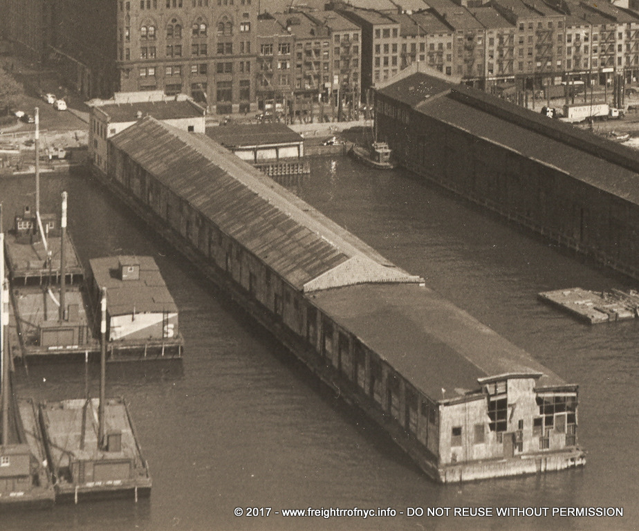
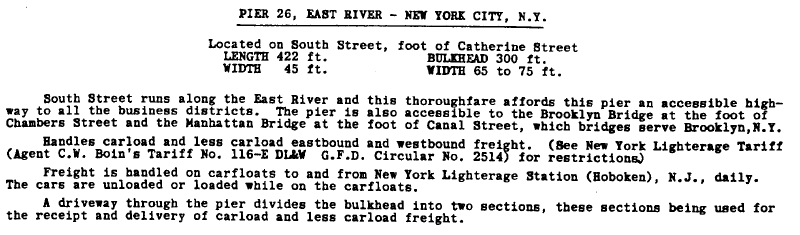
PIER
26 - CATHERINE STREET PIER
STATION
East River, Manhattan
(DELAWARE, LACKAWANNA & WESTERN RAILROAD)
DL & W Pier Station S
...
The following is an excerpt from the Delaware, Lackawanna & Western RR 1952 Directory of Industries & Facilities:
.
.
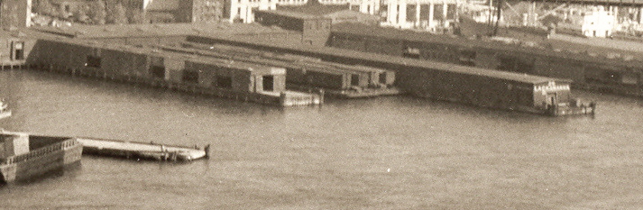
Delaware, Lackawanna & Western Railroad Catherine
Street Freight Station / Pier 26 (East River) - unknown date
(looking north)
courtesy of J. DeMay
collection
added 26 June 2010
.
.
| RETURN TO MAIN INDEX |
..
PIER
57 - EAST 47TH STREET PIER
STATION
East River, Manhattan
(LEHIGH VALLEY RAILROAD)
DL & W Pier Station S
The Lehigh Valley Railroad maintained a Pier Station located on Pier 57 (East River). While the description accompanying this photo was marked "Pier 97", the location given is the "foot of East 47th Street", and the pier is clearly marked Pier 57:
Unfortunately, this pier is not listed in the 1920 Joint Report with Comprehensive Plan & Recommendations, published by the New York New Jersey Port & Harbor Development Commission; and no pier in the vicinity of East 47th Street is shown to be occupied by any railroad in the 1943 New York Central Railroad and Terminal Facilities Map of the Port of New York. (Matter of fact no piers are shown in that area, period.)
Therefore the service years of Lehigh Valley Pier 57 is not clear at this time.
If in fact this pier was located at the foot of East 47th Street on the East River, it was most likely obliterated in the construction of the United Nations.
Lehigh Valley Railroad - East 47th Street Freight Station
/ Pier 57 (East River) - July 10, 1937
P. L. Sperr photo
NYPL Digital Archives
added 01 July 2009
.
.
| RETURN TO MAIN INDEX |
..
.
Inland freight stations were essentially nothing more than large warehouses that received, stored and distributed freight by the various railroads for their various customers.
When the waterfront reached a point of saturation in relation to pier stations, and traffic to and from those pier stations, another location would be selected by the railroads to store freight for their customers. Obviously, these locations would be close enough to the pier stations as to be a short distance, but not so close as to add to the exisiting traffic congestion at the waterfront.
As not every railroad customer would be able to or have the need to pick up their freight as soon as it arrived, the freight of these medium & long term storage customers were usually sent to an Inland Freight Station to keep the limited storage space within the Pier Stations themselves free for fast turnove receiving and shipping.
LEROY
STREET INLAND FREIGHT
STATION
Leroy & West Streets, Manhattan
(ERIE RAILROAD)
E RR / EL / Bronx Terminal / Harlem River / East 149th Street Terminal
.
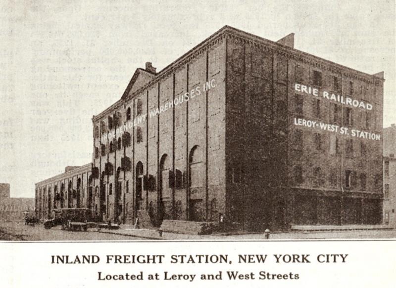
Erie Railroad Leroy Street Inland Freight Station -
ca. 1926
Two page centerfold advertisement of Erie Railroad Inland Freight
Station Facilities in New York & Chicago from:
"The Traffic World"
Vol... XXXVIII, No. 24 - December 11, 1926
authors collection
added 14 July 2009
.
.
| RETURN TO MAIN INDEX |
..
GREENWICH
STREET INLAND FREIGHT STATION
Greenwich Street, Manhattan
(ERIE RAILROAD)
.
.
 .
.
Erie Railroad Greenwich Street Inland Freight Station - ca. 1926
Two page centerfold advertisement of Erie Railroad Inland Freight
Station Facilities in New York & Chicago from:
"The Traffic World"
Vol... XXXVIII, No. 24 - December 11, 1926
authors collection
added 14 July 2009
.
.
| RETURN TO MAIN INDEX |
..
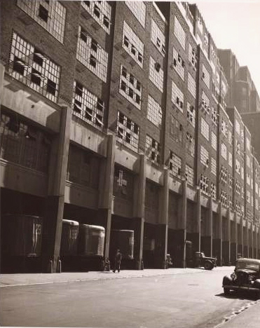
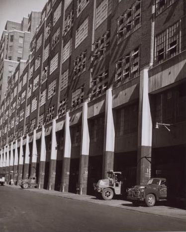
UNION
INLAND FREIGHT
STATION
Ninth Avenue & West 16th Street, Manhattan, NY
(BALTIMORE & OHIO /
CENTRAL RR OF NEW JERSEY,
DELAWARE, LACKAWANNA & WESTERN /
ERIE,
LEHIGH VALLEY / NEW YORK
CENTRAL,
NEW YORK NEW HAVEN &
HARTFORD / PENNSYLVANIA)
DL & W Pier Station S
.
|
|
| .
. |
|
|
| .
. |
|
|
| .
. |
|
Agreement for the use of Union Inland Freight Station in Inland Terminal No. 1
|
| . |
|
|
| . |
|
|
| . |
|
|
| . |
|
|
| . |
|
|
| . |
|
|
| . |
|
|
| . |
|
|
| . |
|
|
| . |
|
|
| . |
|
|
| . |
|
|
| . |
|
|
| .
. |
|
Railway Age - January 22, 1938
|
| . |
|
|
| . |
|
|
| .
. |
|
Delaware, Lackawanna & Western RR 1952 Directory of Industries & Facilities:
|
On 02 December 2011, I received an email from Greg Estren:
I believe I can clarify some of your open questions, in particular the plans for multiple terminals and what ultimately became of this terminal.
The Port Authority conducted research identifying the source and destination of freight shipments throughout Manhattan, then used this research to divide Manhattan (south of 59th Street) into 9 "zones" of equal freight distribution density. They intended to build an inland freight terminal for each zone, i.e. nine terminals in all.
They prepared plans for the first terminal in the zone between Spring Street and Christopher / 10th Streets. But these plans were scuttled by the railroads, who worried that that location would disproportionately benefit certain railroad companies over others (due to proximity of railroad piers). So the Port Authority shifted plans to the current Chelsea location and ultimately built this building.
The railroad's, for reasons I am still somewhat fuzzy on; never liked this building and never used it very much. This, combined with the Great Depression, completely undid the Port Authority's plans for more terminals, and as such they would never build another inland freight terminal. The "Motor Truck Terminal" you mentioned, by the Holland Tunnel, was a separate initiative intended for long-distance trucking, unrelated to the railroads.
The original inland freight terminal continued on operating, well under capacity, through the 50's or so. I'm not sure exactly at what point the railroads stopped doing business there, but eventually the entire terminal area was given over to Railway Express Agency's operations. I would guess the name change from "Union Inland Freight Terminal" to "The Port Authority Building" reflected the Port Authority's trending tendency to play down the (essentially failed) freight purpose of the building. Also note that the term "Port Authority Commerce Building" always had a different meaning than the terminal.
| RETURN TO MAIN INDEX |
..
Like what you see? Suggestions?
Comments?