.
INDUSTRIAL
&
TERMINAL RAILROADS &
RAIL-MARINE OPERATIONS OF BROOKLYN, QUEENS,
STATEN
ISLAND, BRONX &
MANHATTAN:
Less Than Carload Car Load
LCL Pier Dock Station Ferry Pocket Terminal Carfloat Lighterage Break
Bulk New York Central Hudson River West Shore Buffalo Lake Erie Western
Delaware Lackawanna Ontario Vermont
Pennsylvania Shipping Steamship SS Albany Susquehanna Coastwise Barclay Communipaw Cortlandt Pavonia Christopher Street
FREIGHT TERMINAL MAPS
FOR
RAILROADS IN NEW YORK CITY
(and the Hudson River shore of New Jersey
Brooklyn, Bronx, Manhattan, Queens, Staten Island, Weehawken, Hoboken and Jersey City
.
|
updated: |
||
|
|
||
|
update summary: |
date: | chapter: |
| 23 April 2026 | ||
.

.
.
.
.
As I have encountered and saved a growing collection of Freight Terminal Maps of New York City, and mentioned them on the various pages of this website; I felt it was time to display them in one central and convenient location.
.
.
1903 - New York Central & Hudson River Railroad
(J. N. Matthews)
.
.
.
1908 - Proposed Cartage Belt Line for Manhattan
(
William J. Wilgus)

.
1921 - Freight Map of the Metropolitan District
(Empire Map Co)
.
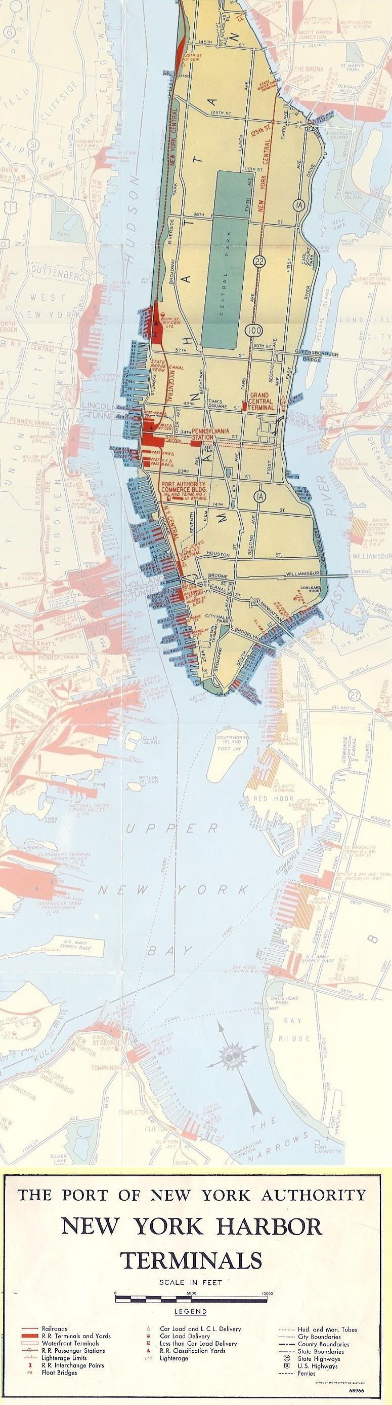
1940 - Pennsylvania Railroad
(Port of New York Authority)
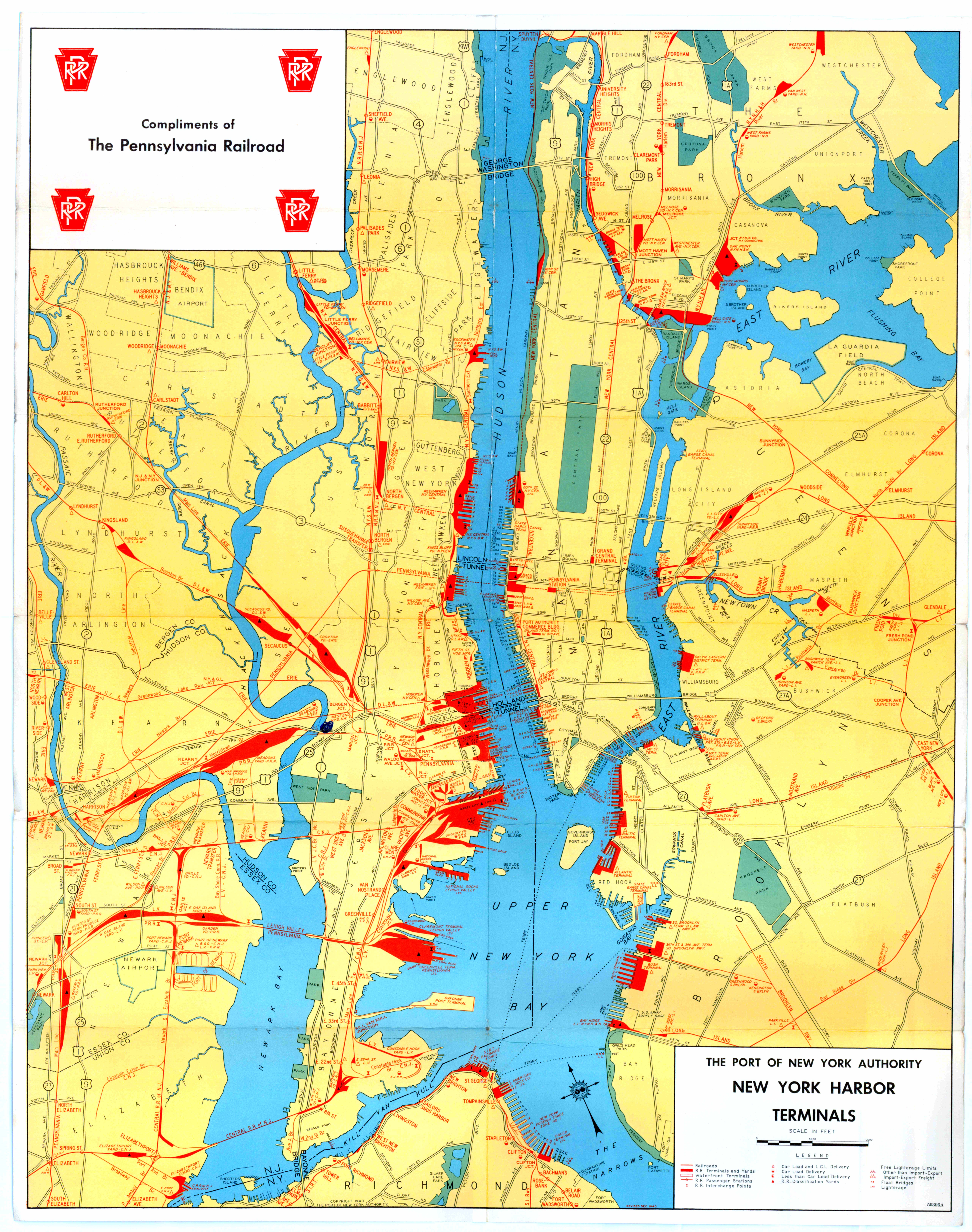
1943 - New York Harbor Terminals
(Port of New York Authority)
The map below will provide you with a guide as to the locations of the pier stations and freight stations mentioned on this page.
Please keep in mind that this map is from 1943, and some pier stations may have been relinquished or may not have opened yet. Only the piers marked in red were railroad operated, but remember: carfloats and lighters could be spotted at any pier for a customer.
.
.
|
Hudson River |
||||||||||||||||||||||||||||||||||||||||||||
| old pier numbering | new pier numbering | |||||||||||||||||||||||||||||||||||||||||||
| foot of street |
1879* (Bromley) |
1885 (Robinson) |
1890-1893 (Robinson) |
1897 (Bromley) |
1902 (Bromley) |
1911 (Bromley) |
1916 (Bromley) |
1920 / 1923 (Bromley) |
1925 (Bromley) |
1935 (PTM) |
1940 (PTM) |
1943 1 (PTM) |
1947 (PTM) |
1952 (PTM) |
1956 (PTM) |
1961 (PTM) |
1965 (PTM) |
1968 (PTM) |
1971 (PRM) |
1977 (PTM) |
links to photos | services | remarks | |||||||||||||||||||||
| W 131 St | MTCo 3 | |||||||||||||||||||||||||||||||||||||||||||
| W 70 St | I | I | NYC&HR | I | NYC&HR | I | NYC&HR | I | NYC | I | NYC | 108 | NYC | I | NYC | I | NYC | I | NYC | I | NYC | I | NYC | I | NYC | I | NYC | I | NYC | I | PC | I | CR | Pier I / 108 | open pier / oversize | |||||||||
| W 68 St | G | NYC&HR | G | NYC&HR | G | NYC&HR | G | NYC&HR | G | NYC | G | NYC | 106 | NYC | G | NYC | G | NYC | G | NYC | G | NYC | G | NYC | Pier G / 106 | FB (3), wb CL 1 | ||||||||||||||||||
| W 66 St | F | NYC&HR | F | NYC&HR | F | NYC&HR | F | NYC&HR | F | NYC | F | NYC | 105 | NYC | F | NYC | F | NYC | F | NYC | F | NYC | F | NYC | Pier F / 105 | eb CL & wb SI 1 | ||||||||||||||||||
| W 65 St | NYC&HR | E | NYC&HR | E | NYC&HR | E | NYC&HR | E | NYC | E | NYC | 104 | NYC | E | NYC | E | NYC | E | NYC | E | NYC | E | NYC | Pier E / 104 | eb LCL1 | |||||||||||||||||||
| W 64 St | NYC&HR | D | NYC&HR | D | NYC&HR | D | NYC&HR | D | NYC | D | NYC | 103 | NYC | D | NYC | D | NYC | D | NYC | D | NYC | D | NYC | Pier D / 103 | eb CL1 | |||||||||||||||||||
| W 63 St | NYC&HR | B | NYC&HR | B | NYC&HR | B | NYC&HR | B | NYC | B | NYC | 102 | NYC | B | NYC | B | NYC | B | NYC | B | NYC | B | NYC | Pier B/ 102 | eb CL1 | |||||||||||||||||||
| W 59 St | NYC&HR (Frt Sta) |
99 | NYC&HR (Frt Sta) |
99 | NYC (Frt Sta) |
99 | NYC (Frt Sta) |
Pier 99 | W 59th St Frt Station |
|||||||||||||||||||||||||||||||||||
| W 49 St | Erie | |||||||||||||||||||||||||||||||||||||||||||
| W 42 St | NYO&W NYWS&B |
BH & 83 | NYC&HR (Frt Sta) |
83 | NYC&HR (Frt Sta) |
83 | NYC (Frt Sta) |
83 | NYC (Frt Sta) |
83 |
NYC (Frt Sta) |
Pier 83 | W 42th St Frt Station |
only one side has openings some WS business |
||||||||||||||||||||||||||||||
| W 41 St | 71 | CRRNJ | 81 | CRRNJ | 81 | CNJ | 81 | CNJ | Pier 81 | part of pier used for rr purposes also shown as Pier 71 - 1911 |
||||||||||||||||||||||||||||||||||
| W 40 St | 80 3 | CNJ (Frt Sta) |
80 | CNJ (Frt Sta) |
80 | CNJ (Frt Sta) |
80 | CNJ (Frt Sta) |
80 | CNJ (Frt Sta) |
80 | CNJ | Pier 80 | West 40th St CL & LCL |
||||||||||||||||||||||||||||||
| W 39 St | 79 | PRR | 79 | PRR | 79 | PC | 79 | CR | Pier 79 | |||||||||||||||||||||||||||||||||||
| W 38 St | 78 | PRR | 78 | PRR | 78 | PRR | 78 | PRR | 78 | PRR | 78 | PRR | 78 | PRR | 78 | PC | 78 | CR | Pier 78 | FB, CL & LCL | fb on south side | |||||||||||||||||||||||
| W 37 St | 67 | PRR | 67 | PRR | 77 | PRR | 77 | PRR | 77 | PRR | 77 | PRR | 77 | PRR | 77 | PRR | 77 | PRR | 77 | PRR | 77 | PRR | 77 | PRR | Pier 77 | FB, CL & LCL | fb on north side | |||||||||||||||||
| W 36 St | 66 | WS | 76 | NYC&HR | 76 | NYC | 76 | NYC | 76 | NYC | Pier 76 | trackage | ||||||||||||||||||||||||||||||||
| (65.5) BH |
PRR | no pier, just freight shed |
||||||||||||||||||||||||||||||||||||||||||
| W 33 St | 63 | NYC&HR | 63 | NYC&HR | 73 | NYC&HR | 73 | NYC | 73 | NYC | Pier 73 | fb on north side | ||||||||||||||||||||||||||||||||
| W 32 St | 62 | NYC&HR | 62 | NYC&HR | 62 | NYC&HR | 72 | NYC&HR | 72 | NYC | 72 | NYC | Pier 72 | FB, CL & LCL | fb on south side | |||||||||||||||||||||||||||||
| W 31 St | 61 | NYC&HR | 61 | NYC&HR | 61 | NYC&HR | 71 | NYC&HR | 71 | NYC | 71 | NYC | Pier 71 | |||||||||||||||||||||||||||||||
| W 28.5 St | 58 | DL&W | 58 | DL&W | 58 | DL&W | 68 | DL&W | 68 | DL&W | 68 | DL&W | 68 | DL&W | 68 | DL&W | 68 | DL&W | 68 | DL&W | 68 | DL&W | 68 | DL&W | 68 | EL | 68 | EL | 68 | EL | Pier 68 | FB, CL & LCL | ||||||||||||
| W 27.5 St | 67 | Erie | 67 | Erie | 67 | Erie | 67 | Erie | 67 | Erie | 67 | Erie | 67 | EL | 67 | EL | 68 | CS | Pier 67 | |||||||||||||||||||||||||
| W 26.5 St | 56 | B&O | 56 | LV | 66 | LV | 66 | LV | 66 | LV | 66 | LV | 66 | LV | 66 | LV | 66 | LV | 66 | LV | 66 | B&O | 66 | B&O | 66 | B&O | 66 | B&O | 66 | CS | Pier 66 | FB, CL & LCL | hay storage outer half only one side has openings |
|||||||||||
| W 23 St | BH | NLE&W | 63 | B&O | 63 | B&O | 63 | B&O | 63 | CS | ||||||||||||||||||||||||||||||||||
| W 15 St | 4 | CNJ | 4 | CNJ | FB, CL & LCL | gone by 1909 | ||||||||||||||||||||||||||||||||||||||
| Gansevoort St | 56 | LV | 52 | PRR | 52 | PRR LIRR |
52 | B&O | 52 | B&O | 52 | B&O | 52 | B&O | Pier 52 | CL | noted on 1956 map | |||||||||||||||||||||||||||
| W 12th St | 51 | B&O | 50 | CR | CL | |||||||||||||||||||||||||||||||||||||||
| 50 | PRR | 50 | PRR LIRR |
50 | PRR | 50 | PRR | 50 | PRR | 50 | PRR | 50 | PRR | 50 | PC | 50 | CR | Pier 50 | CL & LCL | |||||||||||||||||||||||||
| Bank St | 49 | PRR | 49 | PRR LIRR |
49 | PRR | 49 | PRR | 49 | PRR | 49 | PRR | CL | |||||||||||||||||||||||||||||||
| W 11th St | 48 | Erie | 48 | Erie | 48 | Erie | 48 | Erie | 48 | Erie | 48 | EL | 48 | EL | 48 | EL | 48 | EL | Pier 48 | CL & LCL | possible Southern Pacific pier | |||||||||||||||||||||||
| Charles St | 46 | CNJ | 46 | CNJ | 46 | CNJ | 46 | LV | 46 | LV | 46 | LV | 46 | LV | Pier 46 | |||||||||||||||||||||||||||||
| W 10th St | 45 | CNJ B&O | ||||||||||||||||||||||||||||||||||||||||||
| Christopher St | 44 | LV | 44 | LV | Pier 44 | |||||||||||||||||||||||||||||||||||||||
| Barrow St | 43 | PRR | ||||||||||||||||||||||||||||||||||||||||||
| LeRoy St | 48 | CNJ | 41 | DL&W | 41 | DL&W | 41 | DL&W | 41 | DL&W | 41 | DL&W | 41 | DL&W | 41 | DL&W | 41 | DL&W | 41 | DL&W | 41 | DL&W | 41 | DL&W | Pier 41 | CL & LCL | awning shed | |||||||||||||||||
| Clarkson St | 40 | PRR | 40 | PRR | 40 | B&O | Pier 40 | CL | noted on 1956 map | |||||||||||||||||||||||||||||||||||
| W. Houston St | 39 | CNJ, 2 WS, Erie | 39 | CNJ | 39 | CNJ | 39 | CNJ | 39 | B&O | 39 | B&O | 39 | CNJ | Pier 39 | CL & LCL | Erie leases space from CRRNJ | |||||||||||||||||||||||||||
| King St | 38 | LV | 38 | LV | 38 | LV | 38 | LV | 38 | LV | 38 | LV | Pier 38 | CL | part of pier used by CRRNJ | |||||||||||||||||||||||||||||
| Canal St | 34 | LV | 34 | LV / CV | 34 | LV | 34 | LV | Pier 34 | |||||||||||||||||||||||||||||||||||
| Hoboken St | BH. | CNJ | ||||||||||||||||||||||||||||||||||||||||||
| Debrosses / Watts |
31 | NYC&HR | 31 | NYC&HR | 31 | NYC | 31 | NYC | only one side has openings some WS business |
|||||||||||||||||||||||||||||||||||
| 30 | PRR | 30 | PRR LIRR |
30 | PRR LIRR | 30 | PRR | 30 | PRR | 30 | PRR | 28Pier 30 | LCL | |||||||||||||||||||||||||||||||
| Vestry St | 29 | PRR | 29 | PRR | 29 | PRR | 29 | PRR | 28 | PRR | 29 | PRR | 29 | PRR | 29 | PRR | 29 | PRR | 29 | PRR | 29 | PRR | 29 | PRR | 29 | PRR | 29 | PRR | 29 | PRR | 29 | PRR | 29? | ? | 29 | ? | Pier 29 Produce Term'l |
heated pier shed general freight busy terminal |
||||||
| Laight St | 28 | PRR | 28 | PRR | 28 | PRR | 28 | PRR | 28 | PRR | 28 | PRR | 28 | PRR | 28 | PRR | 28 | PRR | 28 | PRR | 28 | PRR | 28 | PRR | 28 | PRR | 28 | PRR | 28 | PRR | 28 | PRR | 28 | ? | 28 | ? | CL & LCL | |||||||
| Hubert St | 38 | PRR | 27 | PRR | 27 | PRR | 27 | PRR | 27 | PRR | 27 | PRR | 27 | PRR | 27 | PRR | 27 | PRR | 27 | PRR | 27 | PRR | 27 | PRR | 27 | PRR | 27 | PRR | 27 | Erie | 27 | EL | 27 | EL | CL & LCL | |||||||||
| Harrison / Franklin St | 23 | NYWS&B | 23 | WS | 23 | WS | 23 | WS / NYOW | 23 | WS | 23 | WS | 23 | B&O | 23 | B&O | 23 | B&O | 23 | CNJ | 23 | CNJ | 23 | CNJ | Pier 23 | CL & LCL | ||||||||||||||||||
| Jay St | 22 | B&O | 22 | B&O | 22 | B&O | 22 | B&O | 22 | B&O | 22 | B&O | 22 | B&O | 22 | B&O | 22 | B&O | 22 | B&O | 22 | B&O | 22 | B&O | 22 | B&O | 22 | B&O? | Pier 22 | |||||||||||||||
| Pier 21 | ||||||||||||||||||||||||||||||||||||||||||||
| Duane St | 31 | NYLE&W | 21 | NYLE&W | 21 | NYLE&W | 21 | NYLE&W | 21 | NYLE&W | 21 | Erie | 21 | Erie | 21 | Erie | 21 | Erie | 21 | Erie | 21 | Erie | 21 | Erie | 21 | Erie | 21 | Erie | 21 | B&O | 21 | B&O | 21 | EL | 21 | EL | Pier 21 | CL & LCL | ||||||
| Chambers St | 20 | NYLE&W | 20 | NYLE&W | 20 | NYLE&W | 20 | NYLE&W | 20 | Erie | 20 | Erie | 20 | Erie | 20 | Erie | 20 | Erie | 20 | Erie | 20 | Erie | 20 | Erie | 20 | Erie | 20 | B&O | 20 | B&O | 20 | EL | Pier 20 | Fruit / Perishables | heated, only one side has openings, | |||||||||
| 19 | Erie | 19 | Erie | 19 | Erie | 19 | EL | |||||||||||||||||||||||||||||||||||||
| Park Pl | 27 | NYC&HR | Old 27 | NYC&HR | 17 | NYC&HR | 17 | NYC&HR | 17 | NYC&HR | 17 | NYC | 17 | NYC | 17 | NYC | 17 | NYC | 17 | NYC | 17 | NYC | 17 | NYC | 17 | NYC | Pier 17 | |||||||||||||||||
| Barclay St | 25 | NYC&HR | 16 | NYC&HR | 25 | NYC&HR | Old 25 | NYC&HR | 16 | NYC&HR | 16 | NYC&HR | 16 | NYC&HR | 16 | NYC | 16 | NYC | 16 | NYC | 16 | NYC | 16 | NYO&W NYC |
16 | NYO&W NYC |
16 | NYO&W | 16 | NYO&W | Pier 16 | |||||||||||||
| Dey / Cortlandt St | 19 | DL&W | 12 | DL&W | DL&W | DL&W | 13 | DL&W | 13 | DL&W | 13 | DL&W | 13 | DL&W | 13 | DL&W | 13 | DL&W | 13 | DL&W | 13 | DL&W | 13 | DL&W | 13 | DL&W | Pier 13 | |||||||||||||||||
| Liberty St | PRR | |||||||||||||||||||||||||||||||||||||||||||
| Cedar St | 14 | CNJ | CNJ | 14 | CNJ | |||||||||||||||||||||||||||||||||||||||
| - | 13 | CNJ | 11 |
CNJ | 13 | CNJ | CNJ | 13 | CNJ | 11 | CNJ | 11 | CNJ | 11 | CNJ | 11 | CNJ | Pier 11 | ||||||||||||||||||||||||||
| Albany St | 12 | CNJ | 10 | CNJ | 12 | CNJ | CNJ | 12 | CNJ | 10 | CNJ | 10 | CNJ | 10 | CNJ | 10 | CNJ | 10 | CNJ | 10 | CNJ | 10 | CNJ | 10 | CNJ | |||||||||||||||||||
| 9 | CNJ | 9 | CNJ | |||||||||||||||||||||||||||||||||||||||||
| Rector St | 8 | CNJ | 8 | NJS | 8 | NJS | 8 | CNJ | 8 | CNJ | 8 | CNJ | 8 | CNJ | 8 | LV | 8 | LV | 8 | LV | 8 | LV | 8 | LV | 8 | LV | 8 | LV | 8 | LV | Pier 8 | |||||||||||||
| 7 | B&O | 7 | B&O | 7 | B&O | 7 | EL | Pier 7 | ||||||||||||||||||||||||||||||||||||
| 6 | PRR | 6 | PRR | 6 | PRR | Pier 6 | ||||||||||||||||||||||||||||||||||||||
| Morris St | 5 | PRR | 5 | PRR | 5 | PRR | 5 | PRR | 5 | PRR | 5 | PRR | 5 | PRR | 5 | PRR | 5 | PRR | Pier 5 | |||||||||||||||||||||||||
| Morris St | 4 | PRR | 4 | PRR | 4 | PRR | 4 | PRR | 4 | PRR | 4 | PRR | 4 | PRR | Pier 4 | |||||||||||||||||||||||||||||
| 3 | LV | 3 | LV | 3 | LV | 3 | LV | 3 | LV | Pier 3 | ||||||||||||||||||||||||||||||||||
| 2 | LV | 2 | LV | 2 | LV | 2 | LV | 2 | LV | 2 | LV | Pier 2 | CL & LCL | operated by CRRNJ in 1914 | ||||||||||||||||||||||||||||||
| Battery Pl | 1 | PRR | 1 | PRR | 1 | PRR | 1 | PRR | 1 | PRR | 1 | PRR | 2 | PRR | 2 | PRR | Pier 1 | |||||||||||||||||||||||||||
| Battery Pl | B | B&O | Pier B | |||||||||||||||||||||||||||||||||||||||||
Notes:
* = incomplete atlas in NYPL archives (volumes missing)
1 = correlates to 1942 ACoE Port & Terminal Facilites, Part 2
2 = inbound only
3 = MTCo = Manhattan Terminal Co.: Joint Company for B&O, LV, Erie, CNJ
When a street is listed as 26.5, this denotes the pier is
located mid-block between two streets, and not physically at the foot of
a street.
BH =
unnumbered Bulkhead House or Freight Shed, not a pier;
B&O = Baltimore
& Ohio; CNJ = Central RR of New Jersey;
CR = ConRail; CS = Chessie System; CV = Central Vermont; DL&W =
Delaware, Lackawanna & Western; Erie = Erie; EL
= Erie Lackawanna;
LV =
Lehigh Valley; NJS = New Jersey Southern;
NYLE&W = New York, Lake Erie & Western; NYO&W
= New York, Ontario & Western; NYC = New York Central;
NYC&HR = New York Central & Hudson River;
NYWS&B
= New York West Shore & Buffalo; PRR = Pennsylvania; WS= West Shore
| East River | ||||||
| railroad | new pier # | old pier # | location | services | dimensions | remarks |
| PRR | E 125th Street | CL & LCL | at confluence of Harlem River, gone by 1956 | |||
| LV | E 124th Street | CL & LCL | at confluence of Harlem River, gone by 1956 | |||
| LV | Pier 57 - E 48th St | FtHs, CL & LCL, Stock Yards | ||||
| NYNH&H | Pier 70 - E 22nd St | no bulkhead platform | ||||
| LV | Pier 44 - Jackson St | CL & LCL | 194' x 69' | |||
| NYNH&H | Pier 42 - Gouvenours Slip Pier 41 - Gouvenours Slip Pier 40 - Gouvenours Slip Pier 39 - Montgomery St Pier 38 - Montgomery St Pier 37 - Clinton St |
LCL, Lighterage | ||||
| NYC | Pier 35 - Jefferrson St | CL & LCL | open bulkhead | |||
| NYO&W / NYC | Pier 34 - Rutgers Slip | CL & LCL | ||||
| NYNH&H | Pier 31 - Pike Slip | no bulkhead platforms | ||||
| CV | Pier 29 - Market Slip | |||||
| DL&W | Pier 26 - Catherine St | CL & LCL | 422' x 45' | shared w/ Atlantic Fruit | ||
| PRR | Pier 25 - Oliver St | 300' x 40' | joint station of LIRR/ PRR | |||
| LIRR | Pier 22 - James Slip | 236' x 50' | joint station of LIRR/ PRR | |||
| B&O & PRR | Pier 21 - Dover St | CL & LCL | double deck pier | |||
| Erie / B&O? | Pier 7 - Coenties Slip | CL & LCL | 571' x 80' | |||
| NYC | Pier 4 - Broad St | |||||
Inland Freight Stations |
||||||
| B&O, CRRNJ, DL&W, Erie, LV, NYC, NYNH&H, PRR |
Ninth Avenue & West 16th Street |
FtHs, CL & LCL | "Union Inland Freight Station" | |||
| Erie | Leroy Street | FtHs, CL & LCL | ||||
| Erie | Watts St | FtHs, CL & LCL | ||||
| Erie | Greenwich St | FtHs, CL & LCL | ||||
| Erie | Hubert St | FtHs, CL & LCL | ||||
Legend
|
FB |
= |
float bridge |
|
CL |
= |
car load delivery only |
|
LCL |
= |
less than car load delivery only |
|
CL & LCL |
= |
car load & less than car load delivery |
|
FtHs |
= |
no pier - inland freighthouse only |
.
..
Like what you see? Suggestions?
Comments?