


.
INDUSTRIAL & TERMINAL RAILROADS & RAIL-MARINE OPERATIONS OF BROOKLYN, QUEENS, STATEN ISLAND, BRONX & MANHATTAN:
High
Line West Side Line West Side Improvement Project Meatpacking District National Biscuit
Nabisco Uneeda cold
storage Merchants Refrigerating Manhattan Refrigerating Hells Kitchen Chelsea Village Tribeca upper horse escort
manhattan cowboy Death Avenue Eleventh Avenue 11th Avenue Tenth Avenue 10th Avenue
Washington
Street
St. John's Park Freight Terminal street running trackage steam dummy
Baldwin American Locomotive ALCO Schenectady 0-4-0 0-6-0 B-B tripower
tri-power Lima Shay
geared 30th Street Branch
NEW YORK CENTRAL & HUDSON RIVER RAILROAD / NEW YORK CENTRAL RAILROAD
.
|
|||||||||||||||||||||||||||||||||||||||||||||


New York Central & Hudson
River / New York Central Railroad
West Side - Manhattan, NY
Maps
| George Snyder Map of the Hudson River RR: | 1848 | |||||||||
|
|
||||||||||
| Matthew Dripps Topographical Survey Maps (1851-1876): |
Battery to Horatio St. (ca. 1854) |
Battery to West 119th St. (1854) |
West 47th to West 134 St. (1876) |
West 128 to West 166th St. (1851) |
West 142 to Spuyten Duyvil (1854) |
|||||
|
|
||||||||||
| G. W. Bromley Property Maps: | 1902 | 1911 | 1913 | 1916 | 1921 | 1955 | ||||
|
|
||||||||||
| New York Central Railroad: | 1917 ROW & Track | 1934 West Side Brochure | 1942 Siding Location Map | |||||||
|
|
||||||||||
| Fairchild Aerial Survey: | 1924 | |||||||||
|
|
||||||||||
| Port Facilities of Port of New York ACoE Maps: | 1932 | 1942 | 1965 | |||||||
|
|
||||||||||
| Port Authority of Port of New York Freight Terminal Map: | 1934 | |||||||||
| . . |
||||||||||
1848 - George Snyder Map of the Hudson River RR
1848 - G. Snyder
Uncropped, uncompressed map here.
Lionel Pincus and Princess Firyal Map
Division
New York Public Library Digital Collection
added 03 July 2026
.
.
While the above map shows the overall geographical scale of the railroad; these next maps appear to be part of an survey atlas, as the remnants of binding can be seen on some of the edges. These maps were published by Matthew Dripps in 1851 through 1854 (inferred).
It appears some plates or partial plates are from one issue, and
other plate from another. I have further cropped them to show the
pertinent areas. The uncropped and uncompressed versions may be
seen through the link under each map.
1854 - Matthew Dripps: The Battery to Horatio Street
Matthew Dripps - 1854 (inferred)
The Battery to Horatio Street
Uncropped, uncompressed map here.
Lionel Pincus and Princess Firyal Map
Division
New York Public Library Digital Collection
.
.
1854 - Matthew Dripps: The Battery to West 119th Street
map based on
Randel's and other official surveys, drawings and modern surveys by
J.F. Harrison & T. Magrane; published by M. Dripps - 1854
The Battery to West 119th Street
This particular plate has been written on, in regards to the layout of the Hudson River Railroad.
While omitted from the original plate, the railroad was penned in through the West 30th Street area,
then again south of West 14th Street.
Uncropped, uncompressed map here.
Lionel Pincus and Princess Firyal Map
Division
New York Public Library Digital Collection
added 03 July 2026added 03 July 2026
.
.
map
based on Randel's and other official surveys, drawings and modern
surveys by J.F. Harrison & T. Magrane; published by M. Dripps - 1854
The Battery to West 119th Street
This particular plate has been written on, in regards to the layout of the Hudson River Railroad.
While omitted from the original plate, the railroad was penned in through the West 30th Street area,
then again south of West 14th Street.
Uncropped, uncompressed map here.
Lionel Pincus and Princess Firyal Map
Division
New York Public Library Digital Collection
added 03 July 2026added 03 July 2026
.
.
1851 - Matthew Dripps: West 128th Street to West 166th Street
.
M. Dripps - est. 1858
West 128th Street through West 166th Street
Uncropped, uncompressed map here.
Lionel Pincus and Princess Firyal Map
Division
New York Public Library Digital Collection
added 03 July 2026
..
.
1854 - Matthew Dripps: West 142nd Street through Spuyten Duyvil
Surveys by J.F. Harrison & T. Magrane; published by Matthew Dripps - 1854
West 142nd Street to Spuyten Duyvil
Uncropped uncompressed map here.
Lionel Pincus and Princess Firyal Map
Division
New York Public Library Digital Collection
added 03 July 2026
.
.
1911- G. W. Bromley Property Atlas; West 142nd to West 158th Streets
.
G. W. Bromley - 1911
Plate
New York Public Library Digital Collections
Lionel Pincus and Princess Firyal Map Division
added 05
April 2024
.
.
1902 - G. W. Bromley Property Atlas; West 71st to West 58th Streets
G. W. Bromley - 1916
Plates 6, 4, 2
Roundhouse, Coal Storage, Pier I, Transfer Bridges 4, 3, 2, Pier G, Pier F, West 65th Street Fregiht Office, Pier E, Pier
D, Pier B, Grain Elevator A,
Rossiter
Warehouse, Stock Pens, Union Stock Yard, carman's Hotel, Eleventh Avenue running tracks
New York Public Library Digital Collections
Lionel Pincus and Princess Firyal Map Division
added 05
April 2024
.
.
1911 - G. W. Bromley Property Atlas; West 64 - West 47th Street

G. W. Bromley - 1911
Plate 24
Pier D, Pier B, Grain Elevator A, West 59th Street Freight
Station, Rossiter Warehouse, Stock Pens, Union Stock Yard, Eleventh
Avenue running tracks
New York Public Library Digital Collections
Lionel Pincus and Princess Firyal Map Division
added 04
June 2026
.
.
1916 - G. W. Bromley Property Atlas; West 71st to West 58th Streets
.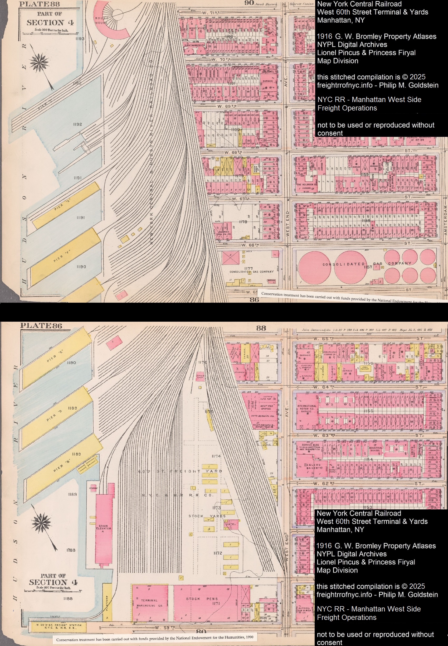
G. W. Bromley - 1916
Plates 88, 86
Roundhouse, West 72nd - West 60th Street Yards, Rossiter Warehouse, Union Stock Yard, Stock Pens
New York Public Library Digital Collections
Lionel Pincus and Princess Firyal Map Division
added 05
April 2024
.
.
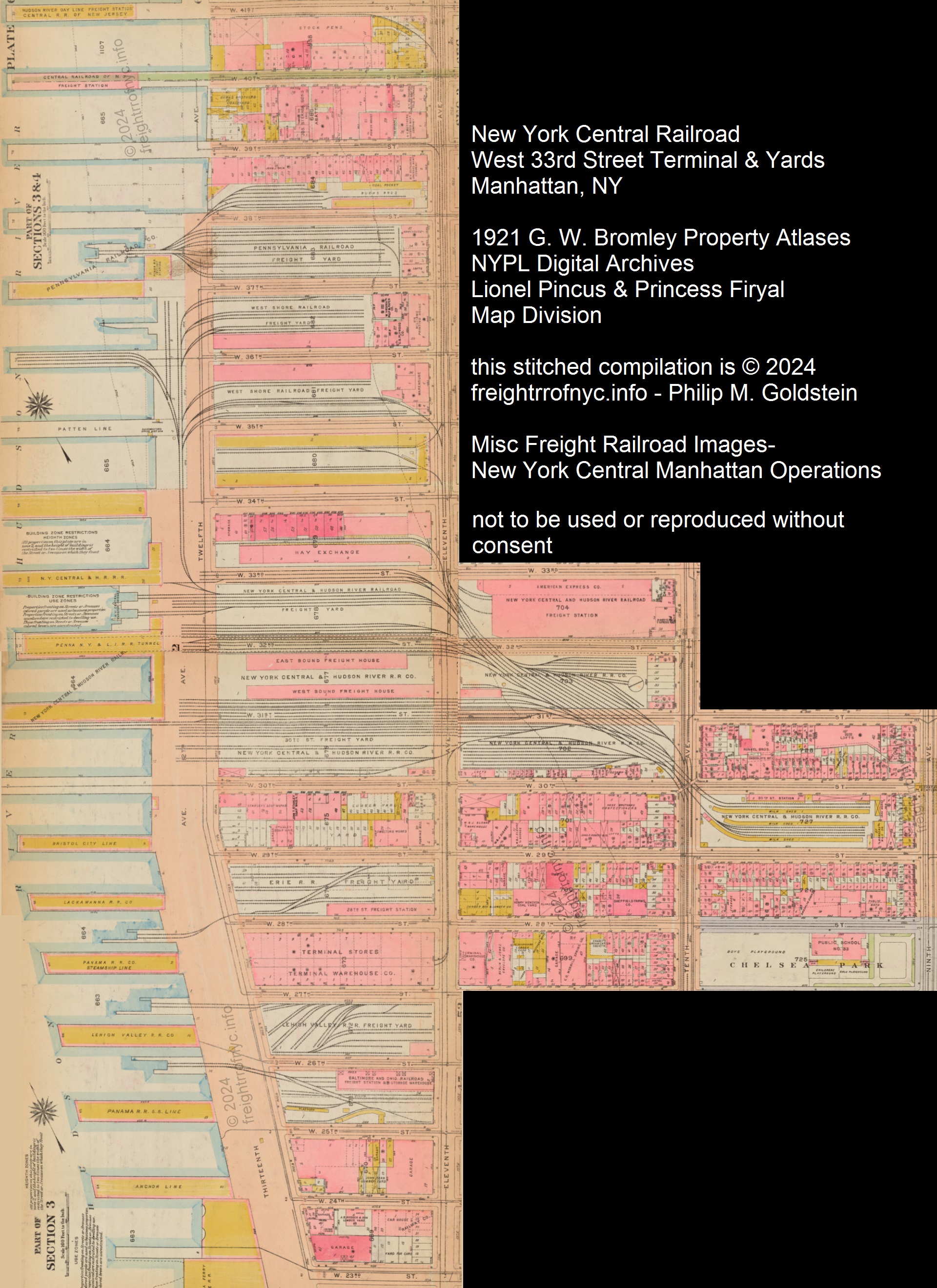
1911 - G. W. Bromley Property Atlas; West 36st to West 25th Street
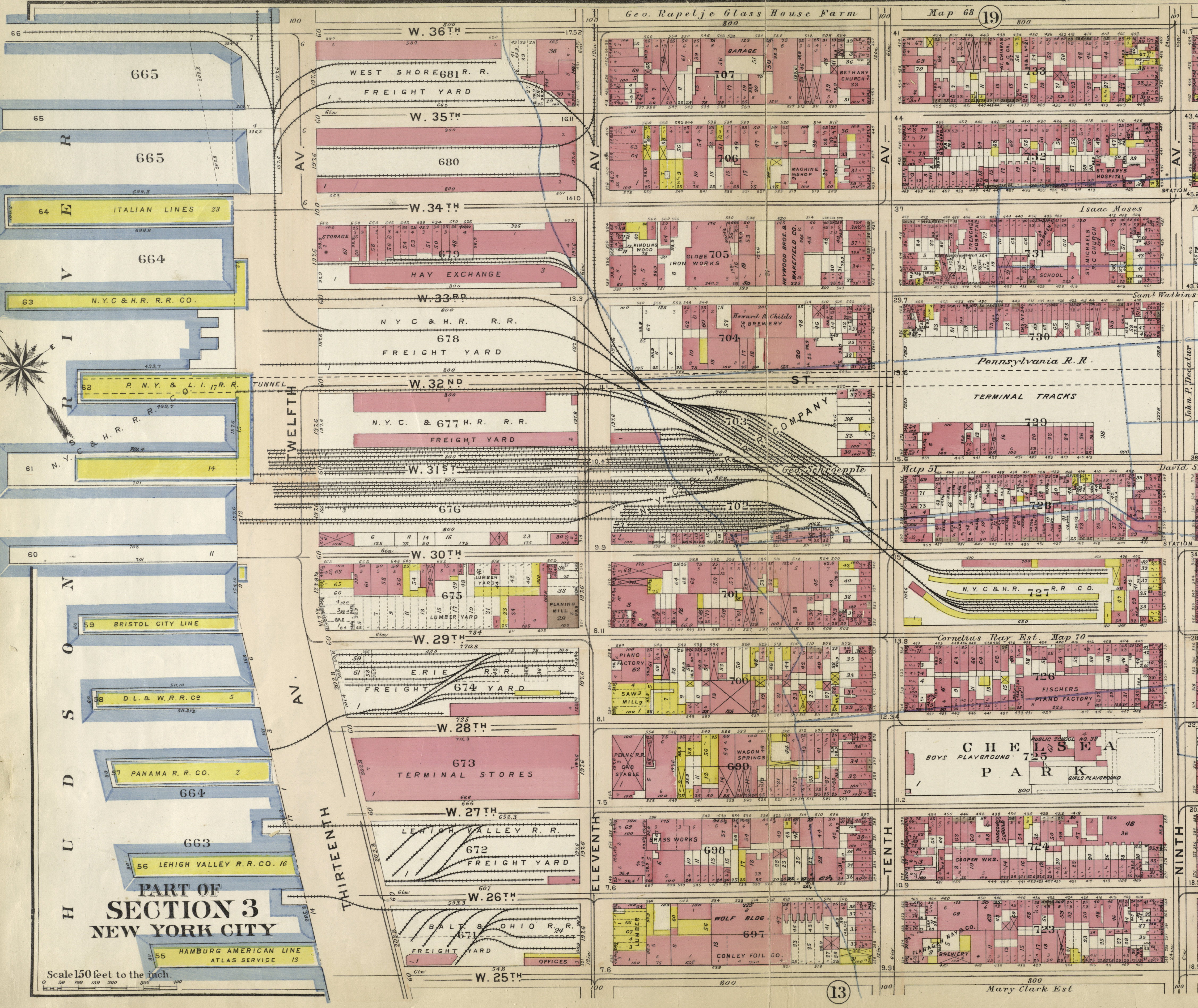
1913 - G. W. Bromley Property Atlas; West 41st to West 23rd Streets
G. W. Bromley - 1913
Plate 13
West 41st Street Stock Pens, Pennsylvania RR West 37th Street
Freight Station, Meatpackers Row, Hay Exchange, West Shore RR West 36th
West 35th Street Yards,
New York Central & Hudson River RR West 34th, 33rd , 32nd,
31st , 30th, 29th Street Yards, West 30th Street Station, Milk Platforms
Eleventh Avenue running tracks, Tenth Avenue running tracks
New York Public Library Digital Collections
Lionel Pincus and Princess Firyal Map Division
added 05
April 2024
.
.
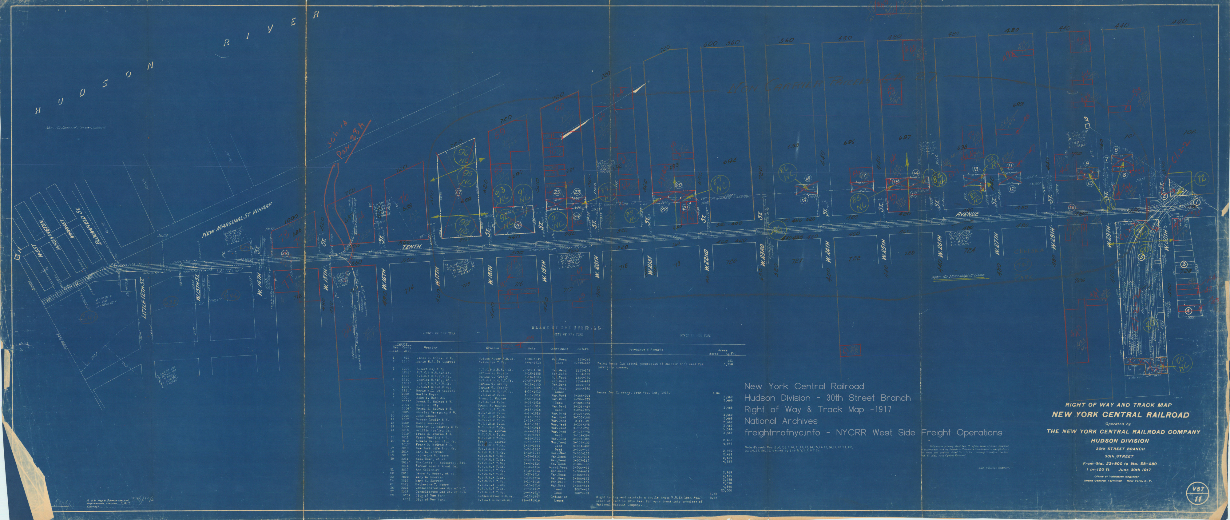
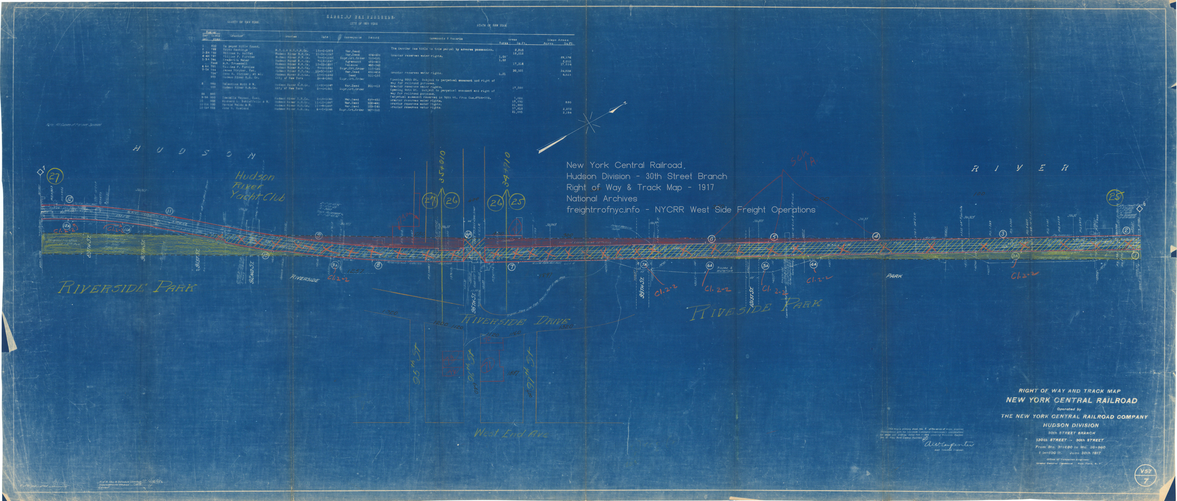
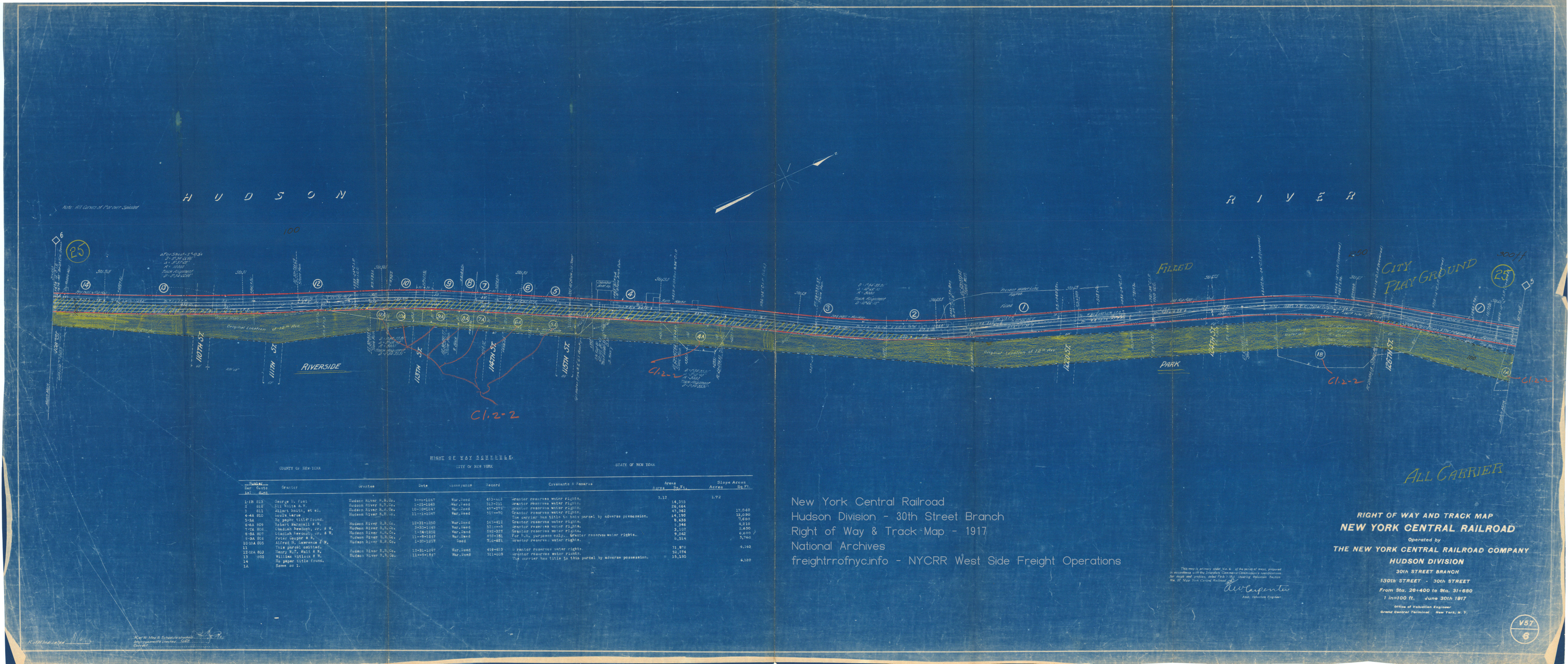
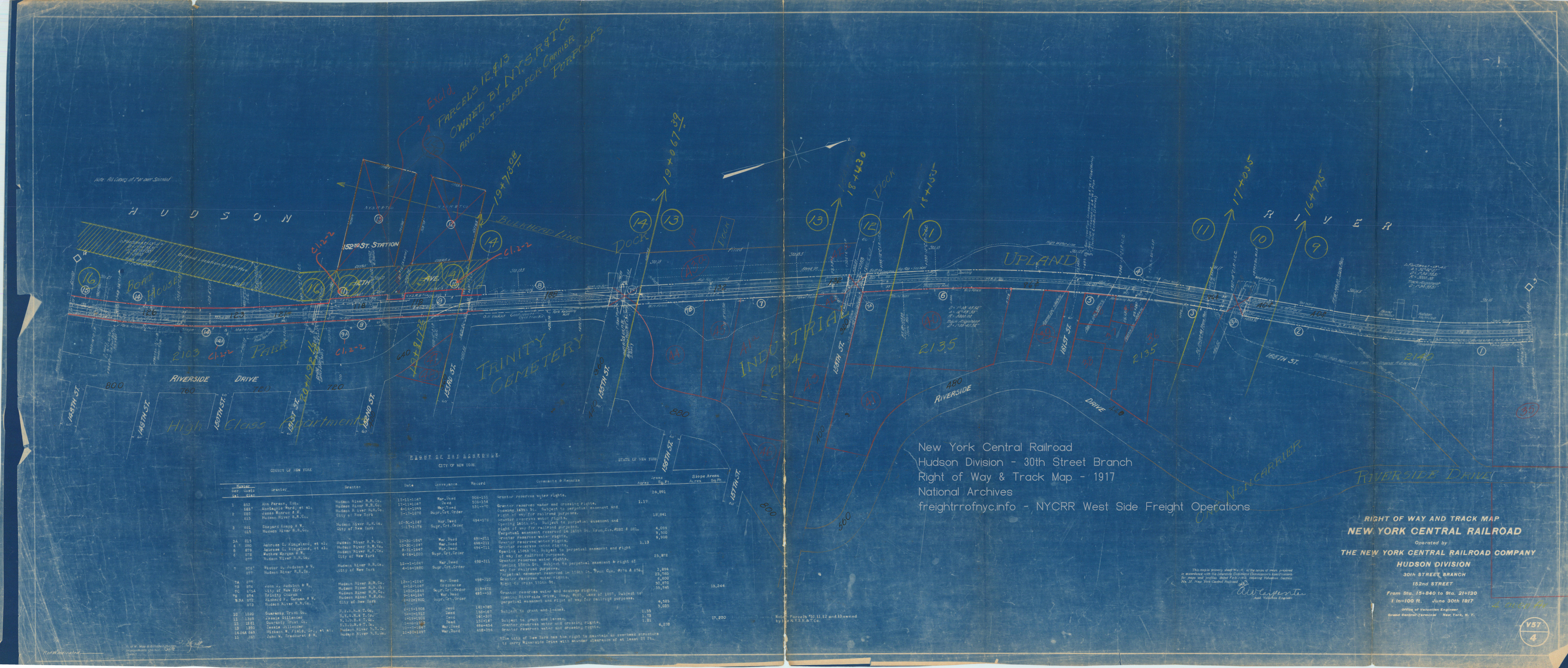
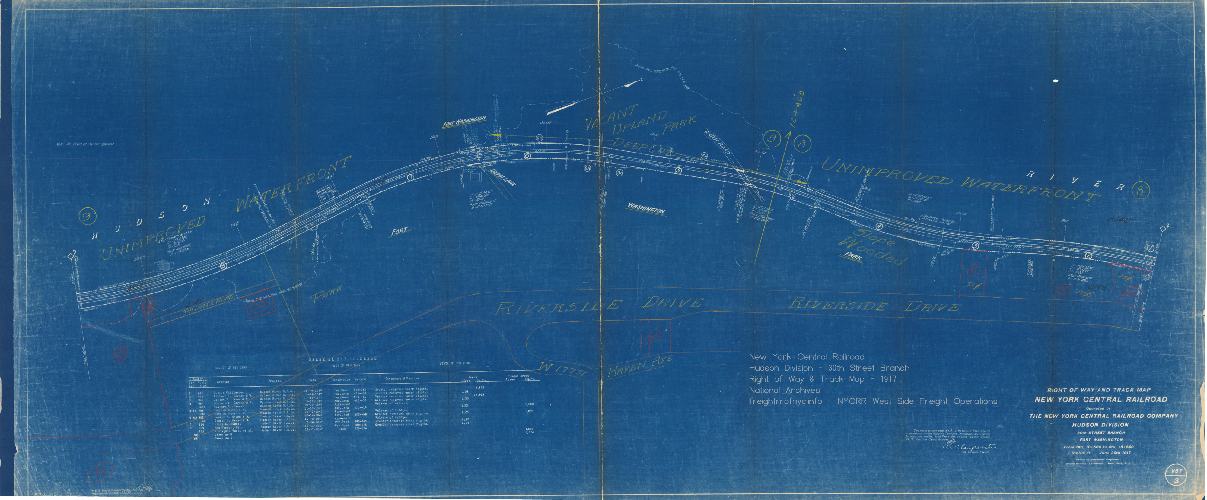
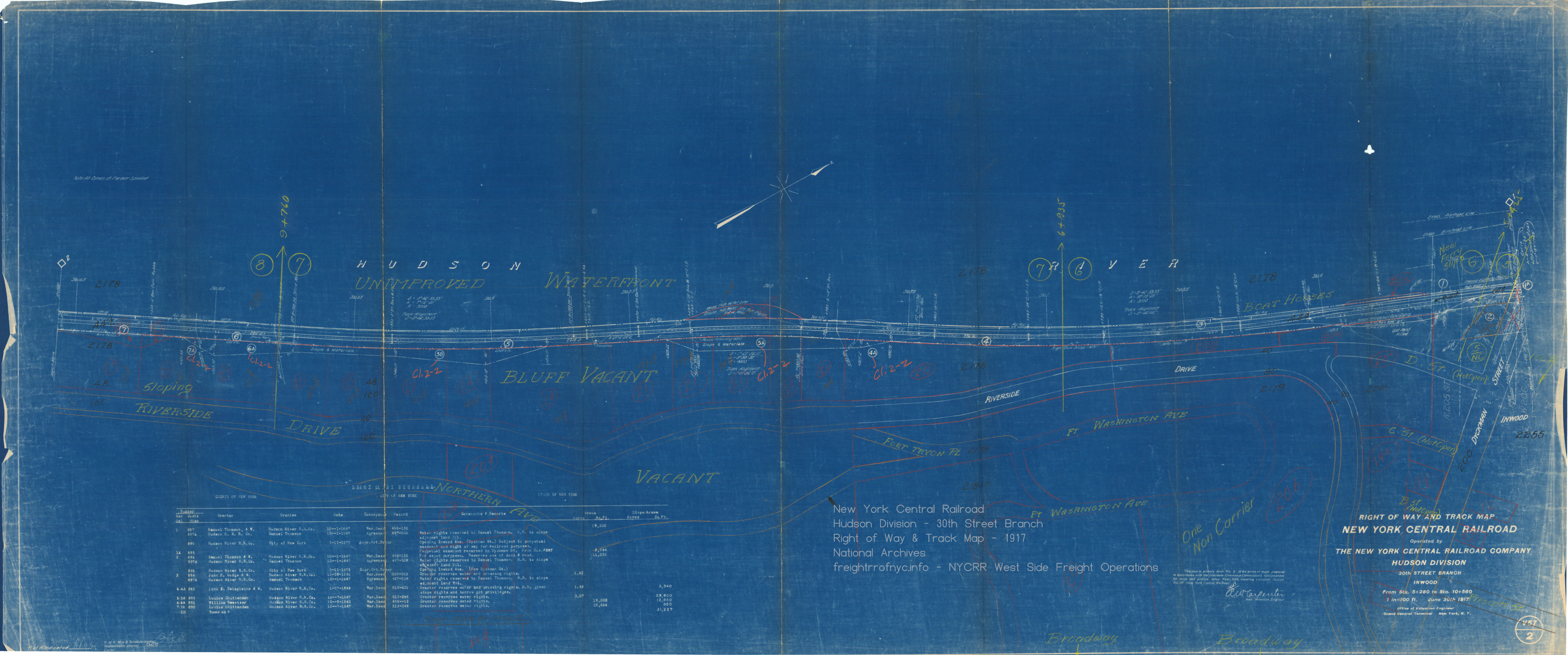
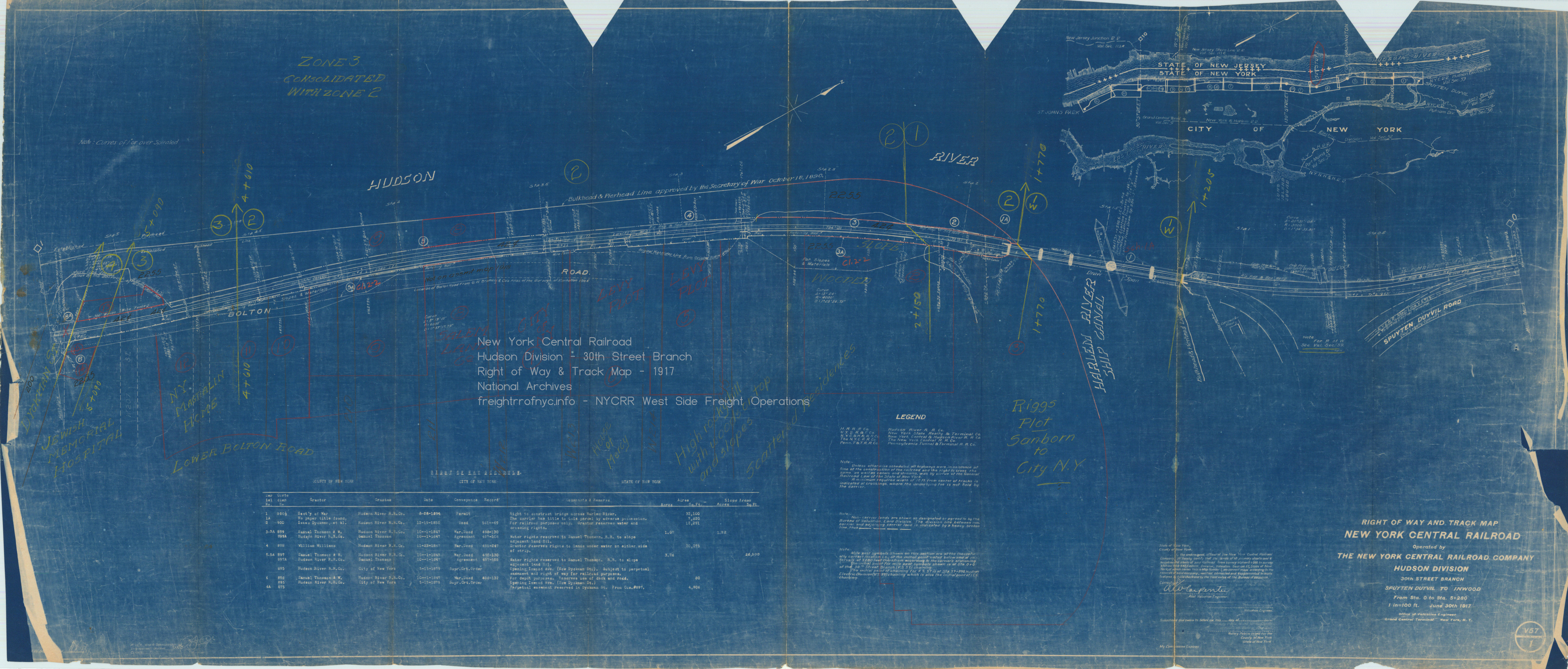
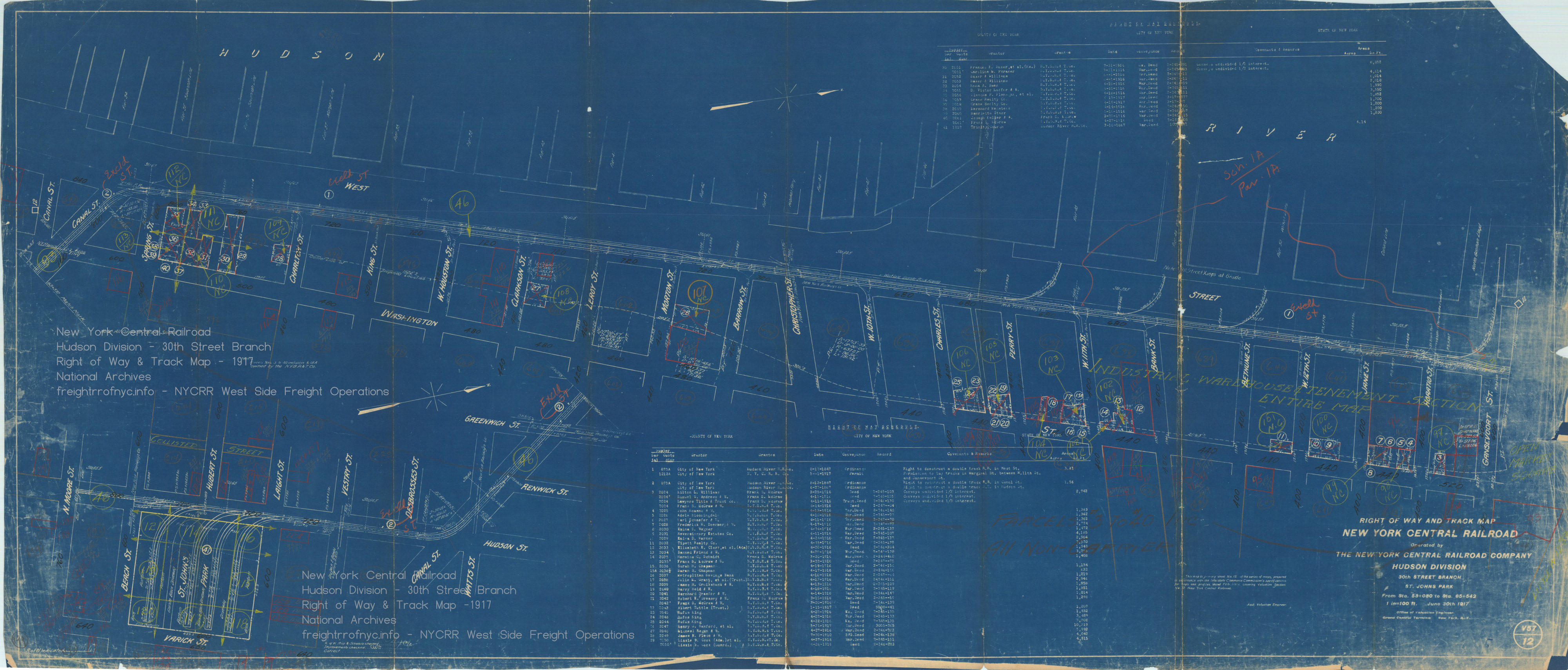
1917 - New York Central Right of Way & Track Maps
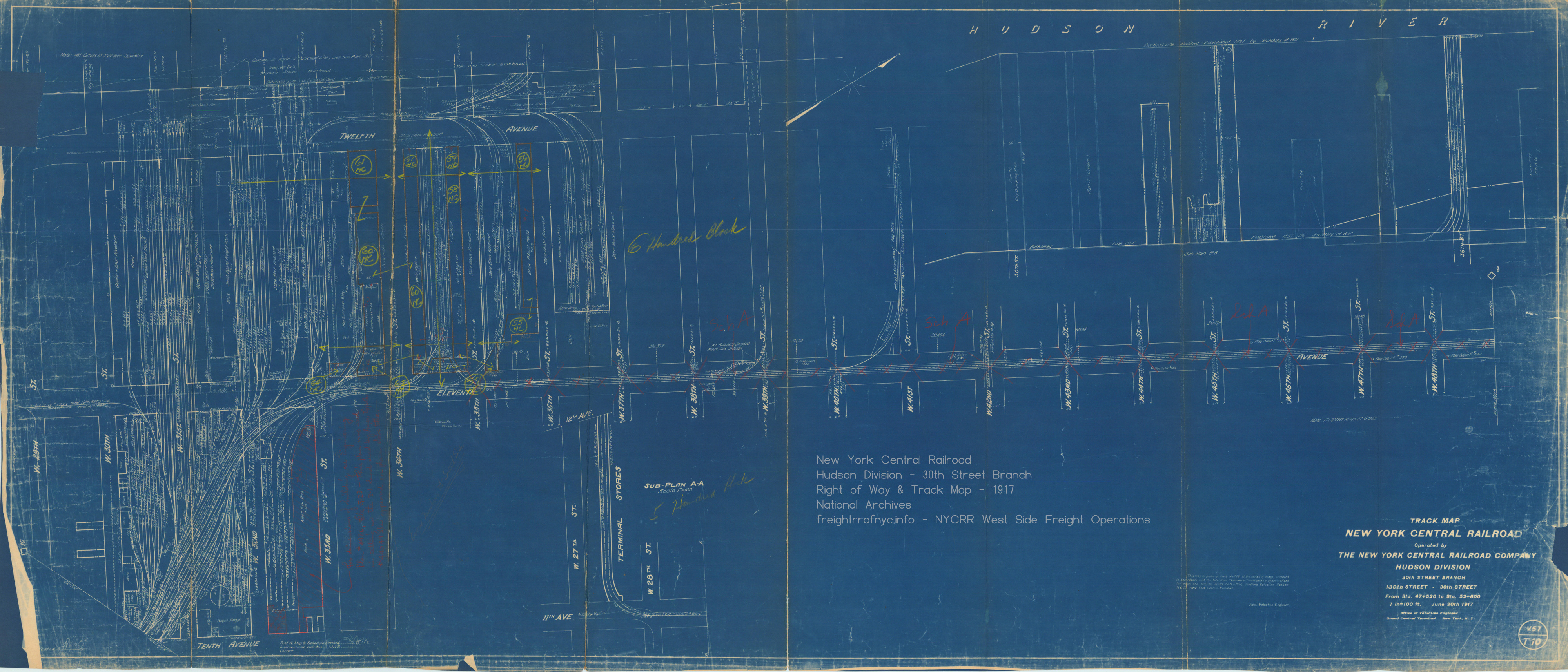
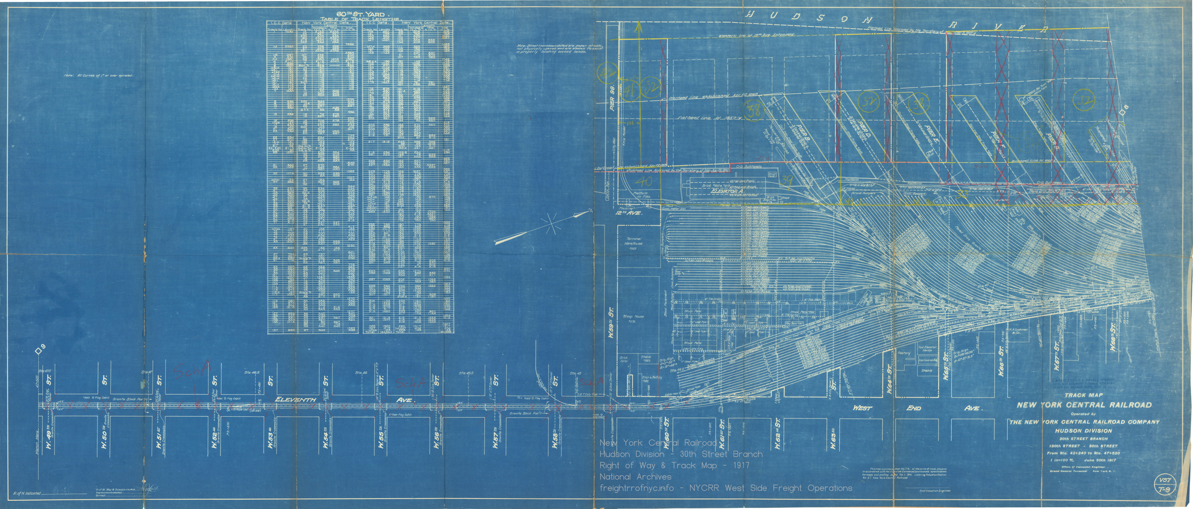
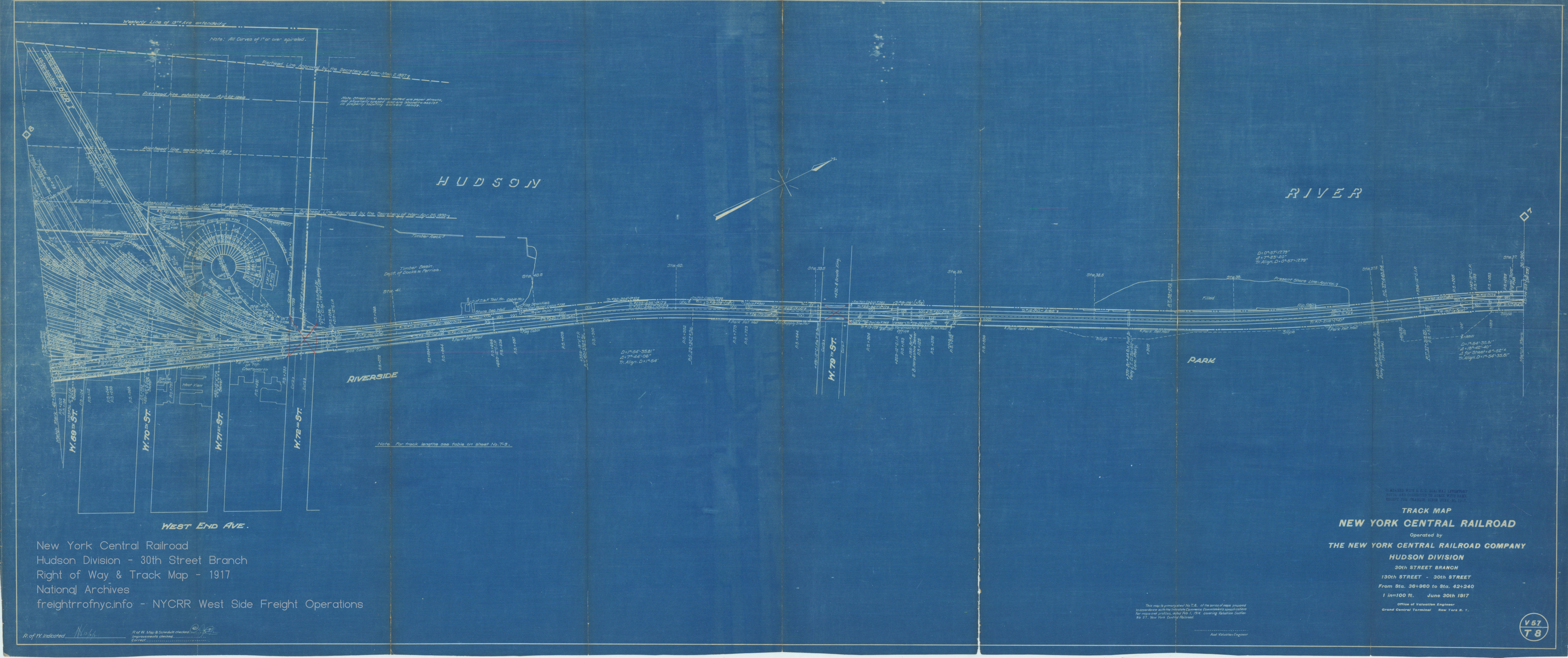
.
.
.
.
1921 - G. W. Bromley Property Atlas
.
.
.
.
G. W. Bromley Property Atlas - 1921
Plate 36, 21, 10 - King Street to Beach Street
West Street running tracks, Canal Street running tracks, Hudson Street running tracks; St. John's Park Freight Station
New York Public Library Digital Collections
Lionel Pincus and Princess Firyal Map Division
added 26 June 2026
.
.
1924 - Fairchild Aerial Survey Photo
several plates stitched by author - © 2026
click for high resolution image.
New York Public Library Digital Archives
.
.
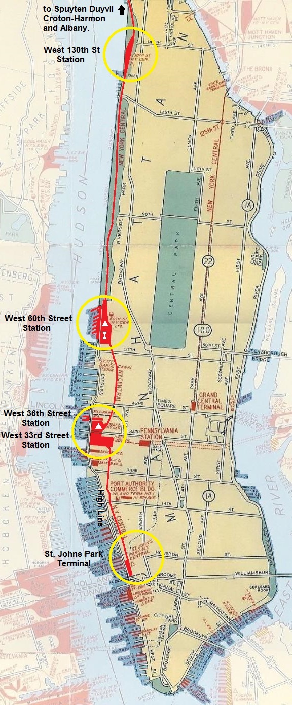
ca. 1934 New York Central West Side Line
Map
of New York Central's West Side Line - unknown year (ca. 1930) as the
private right of way is proposed.
Spuyten Duyvil to St. Johns Park Terminal
dashed
line shows street routing prior to 1933
solid line shows tunnel and High Line routing post 1937
This is a multi-panel fold out map contained in the West Side Improvement Brochure published by the New York Central in 1934
New York Central Historical Society?
added 05
April 2024
.
.
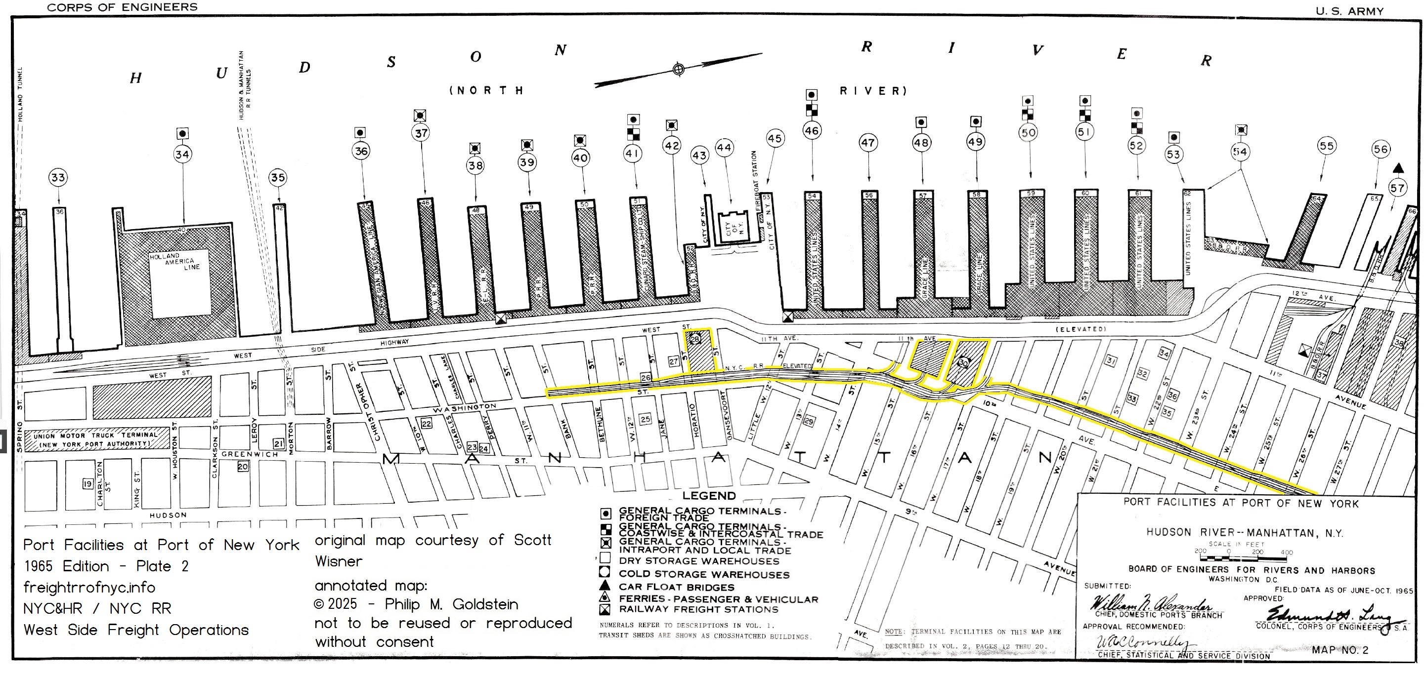
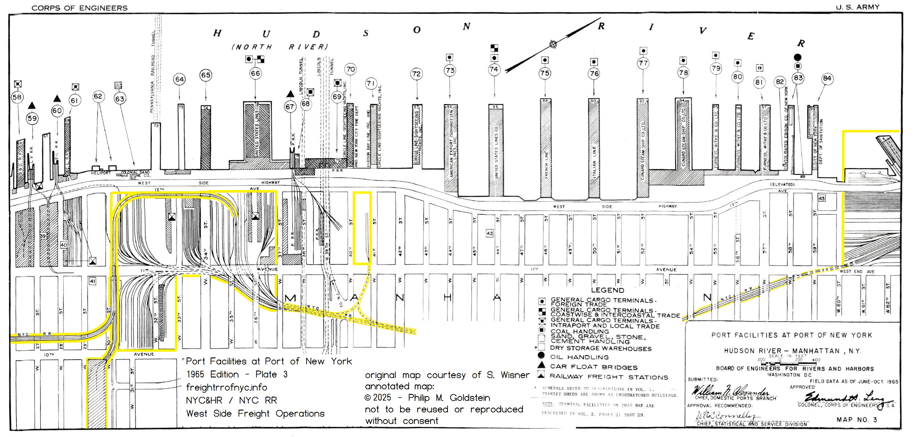
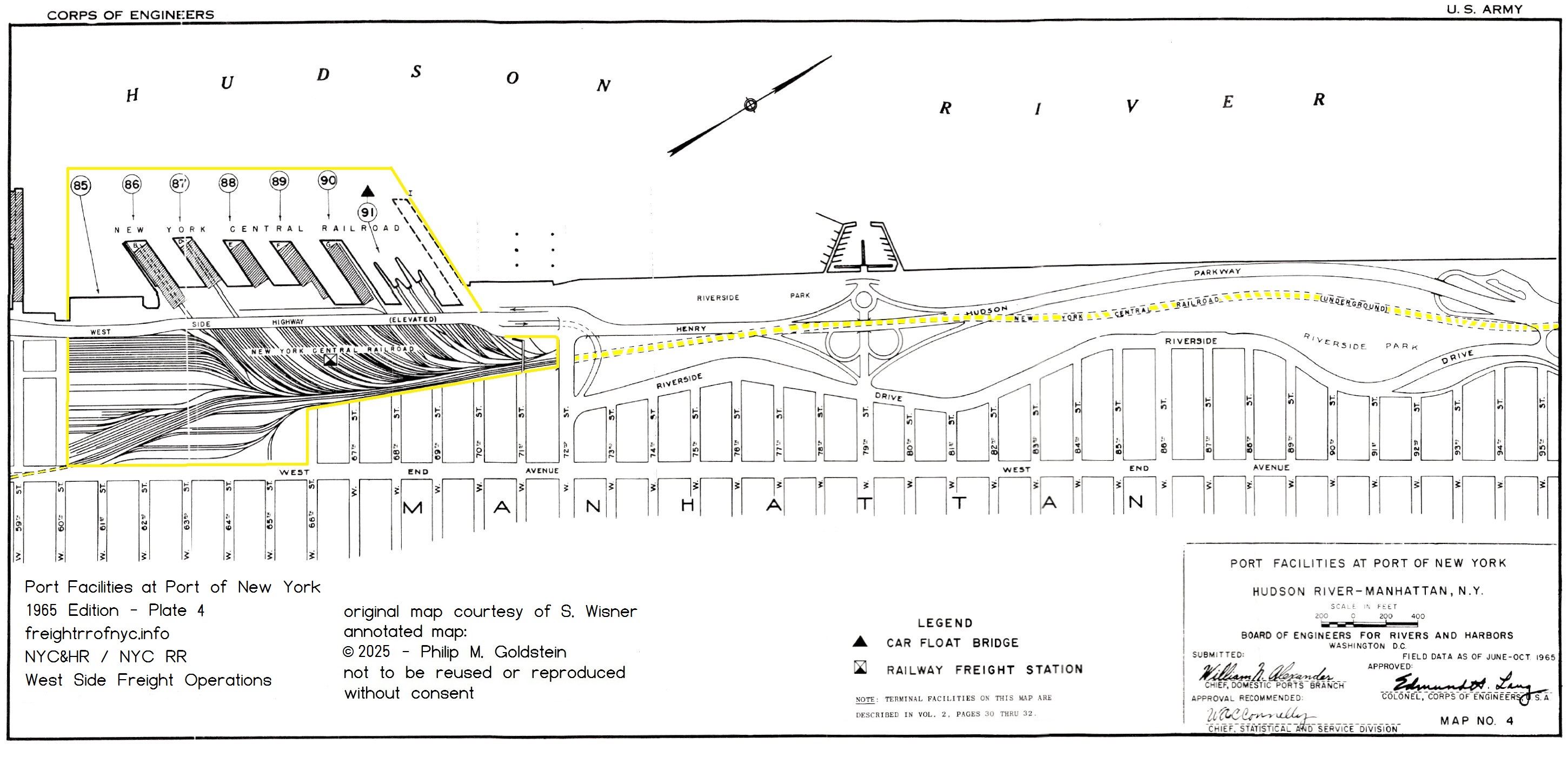
1932 - Port Facilities at Port of New York - War Department / US Army Corps of Engineers
The 1932 Edition of Series Port Facilities Maps below have
been
digitized by the University of Missouri-St Louis. I have acquired a
digitized set of the 1942 Edition from University of Texas - Austin. I
have annotated these plates to identify the routing of New York Central
West Side Line through
Manhattan and the associated facilities served by that line.
I am desperately seeking the 1926, 1953 Edition
and
1965 Editions; at the very least - the
segment of the High Line.
We know they
exist, but apparently have not been digitized. If you know
where a
set is located or have a set already digitized, please contact me
at bedt14@aol.com
.
.
.
.
.
.
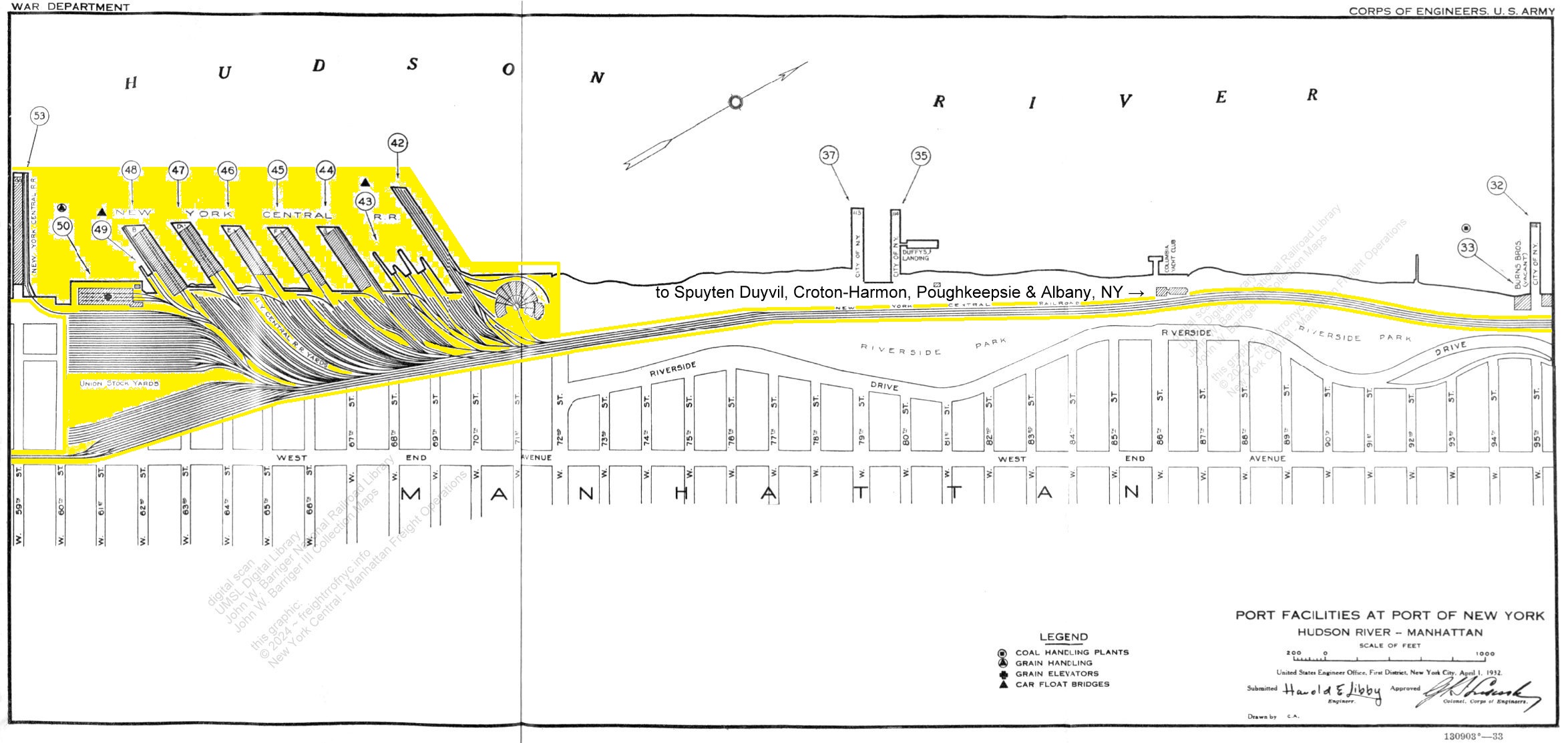
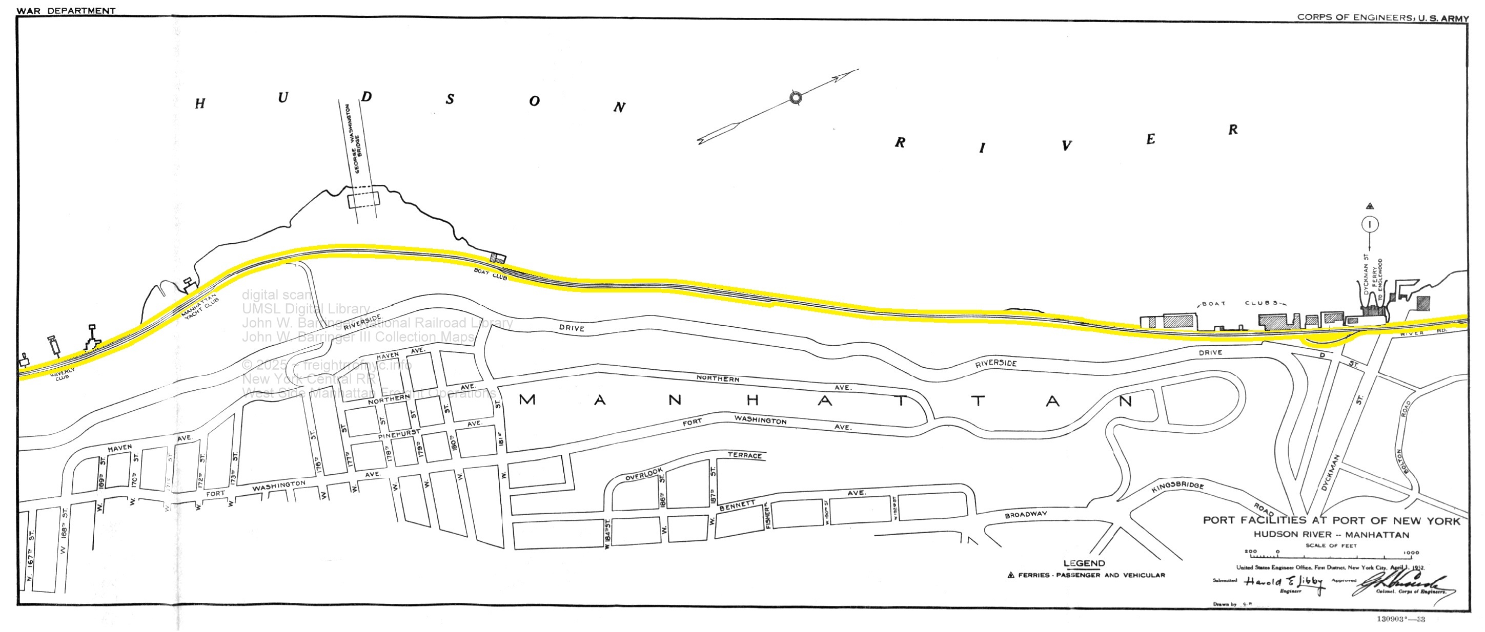
Port Facilities at Port of New York
- 1932
Plate
32: West 59th Street to West 95th Street
including Union Stock Yards,
West 60th Street Yard, Transfer Bridges, Roundhouse &
Turntable,
Piers and Piersheds
added
05 April 2024
.
.
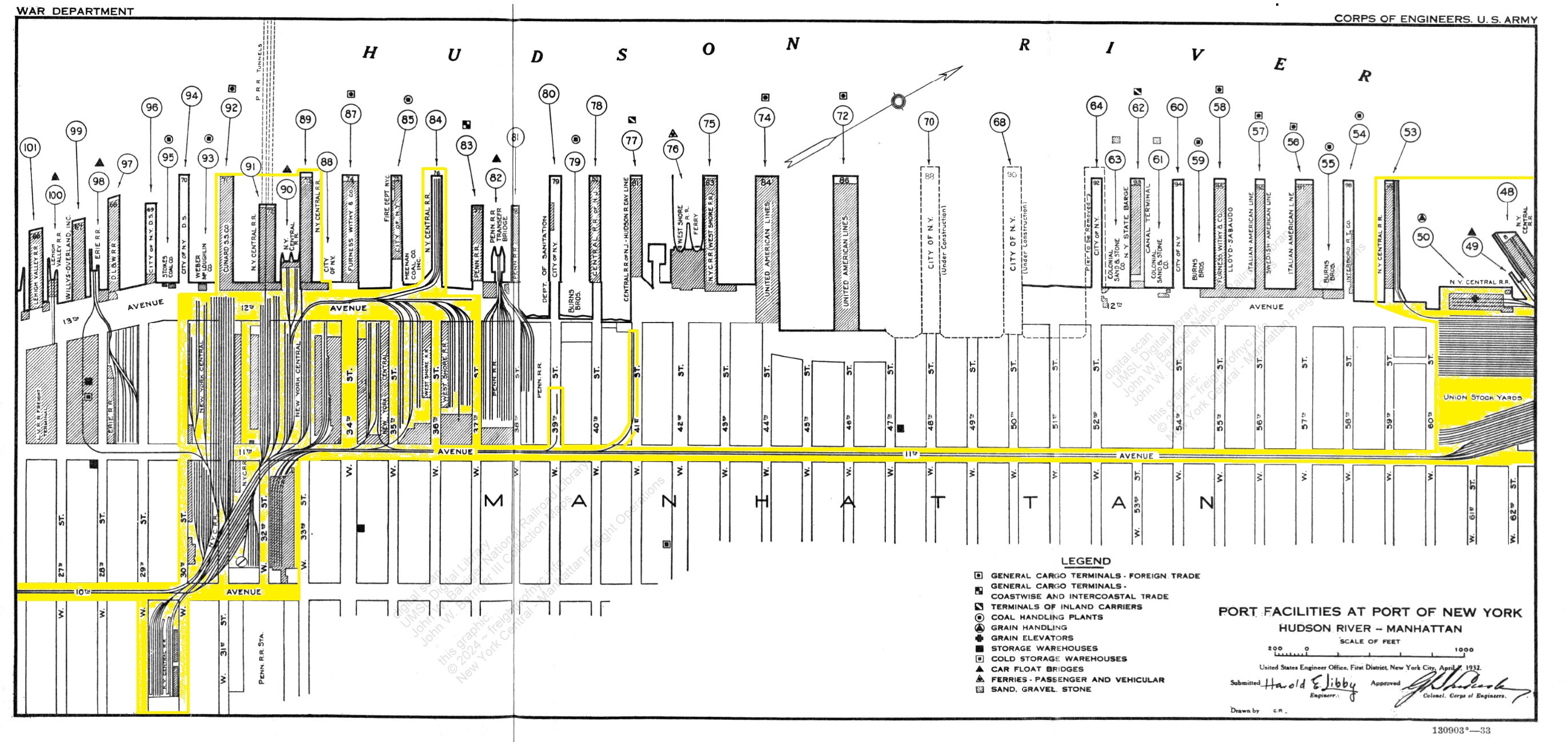
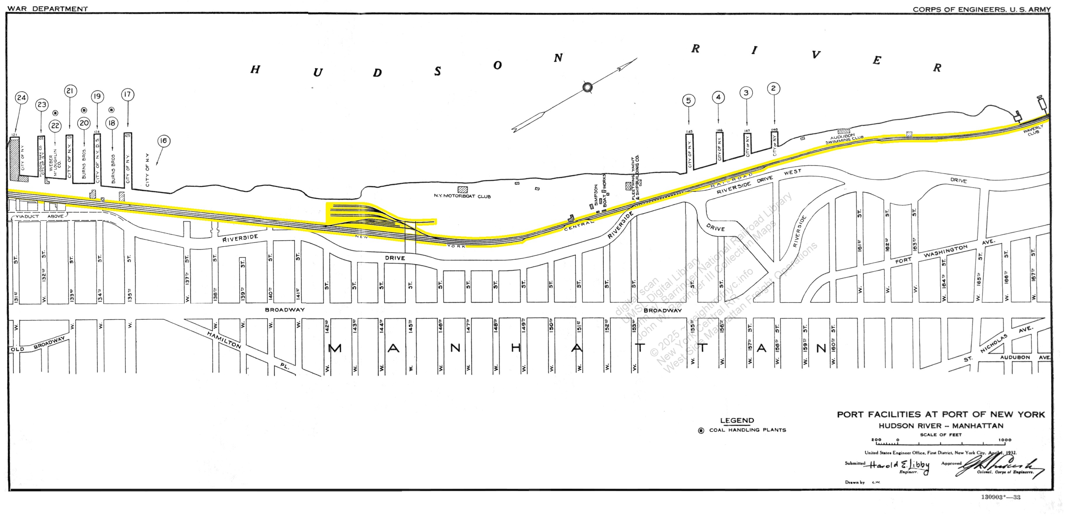
Port Facilities at Port of New York
- 1932
Plate
33 - West
26th Street to West 62th Street including
West 30th Street Yard, West 33rd Street Yard, West 36th Street Yard;
West 41st Street spur to Stock Yard & Slaughterhouses
offline rail-marine terminals of Lehigh Valley Railroad at West
27th Street, Erie Railroad at West 28th Street and
Pennsylvania Railroad at West 37th Street Terminals; and railroad pier
stations.
added
05 April 2024
.
.
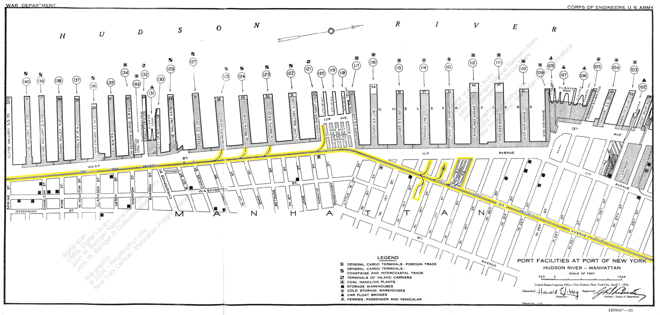
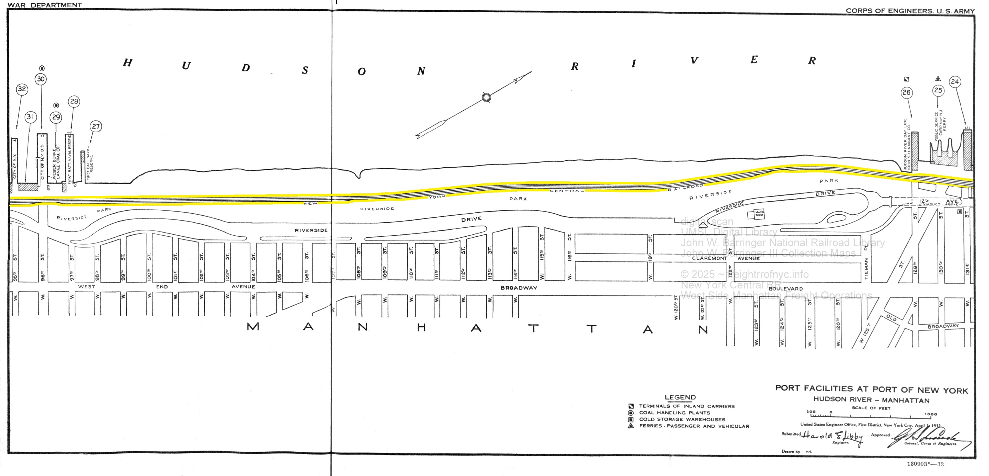
Port Facilities at Port of New York - 1932
Plate
34: Spring Street to West 28th Street, including West 17th Street Yard;
New West Washington Market, industrial and piershed sidings, West
Street and Tenth Avenue running tracks,
including
area offline rail-marine terminals of Baltimore & Ohio Railroad
West 26th Street and Lehigh Valley Railroad West 27th Street; and
railroad pier stations.
added
05 April 2024
.
.
Port Facilities at Port of New York - 1932
Plate
35: Battery Park to Spring Street,
including St Johns Park Terminal,
Hudson Street Canal Street and West Street running tracks.
added
05 April 2024
Port of New York Authority -
Freight Terminal Map - 1934
authors
collection
annotated by author © 2024 ~ freightrrofnyc.info
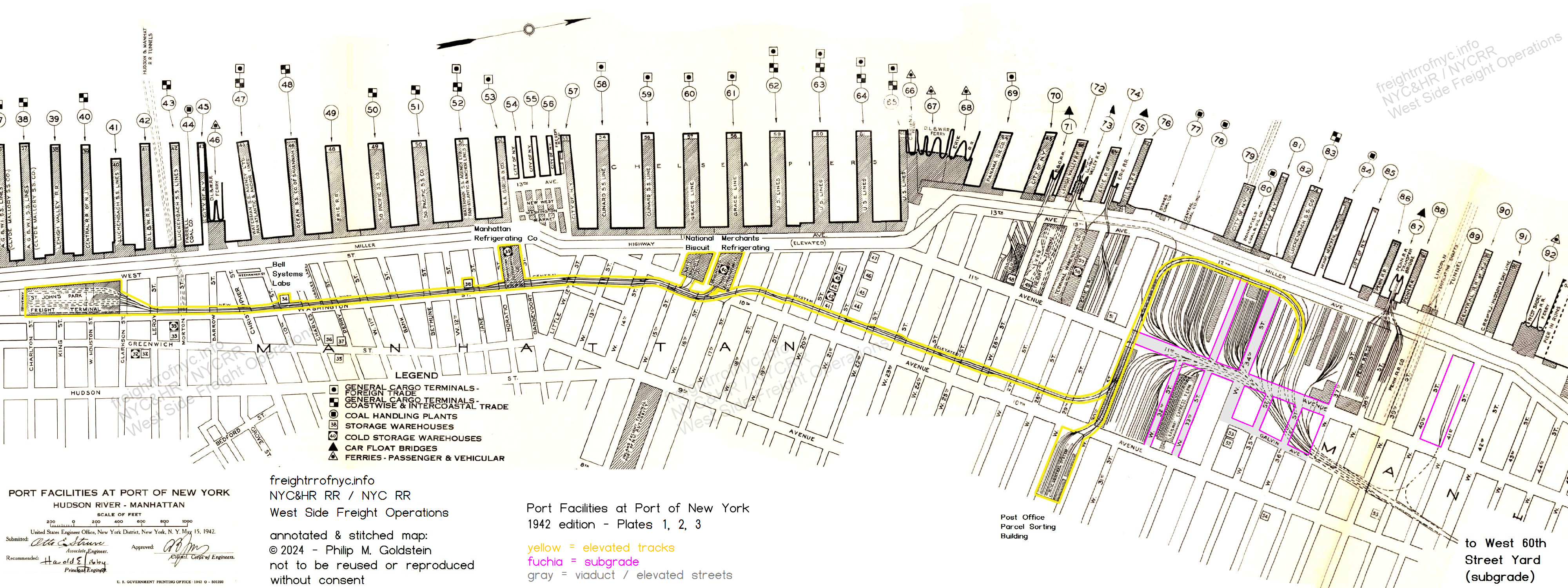
Port Facilities at Port of New York - 1942
Plates 1, 2, 3, stitched: Charlton Street to West 42nd Street:
New York Central High Line: St Johns Park Freight Terminal, West 30th,
33rd, 36th, West 41st Street spur to Stock Yard & Slaughterhouses
Key numbers correspond to lists contained in Port
and Terminal Facilities at Port of New York; Part 1; commencing on page
60.
Yes, I have a copy, please email
if needed.
authors
collection
.
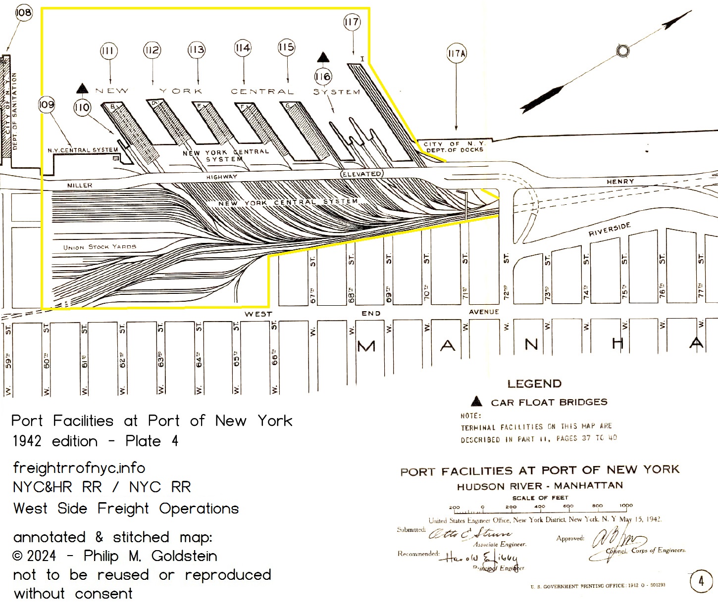
Port
Facilities at Port of New York - 1942
Plate 4, West 59th Street to West 77th Street, New York Central High
Line, West 60th Street Yard & Terminal, Grain
Elevators,
Transfer Bridges, Union Stock Yards.
Key numbers correspond to lists contained in Port
and Terminal Facilities at Port of New York; Part 1; commencing on page
60.
Yes,
I have a copy, please email
if needed.
authors
collection
added 29
April 2024
.
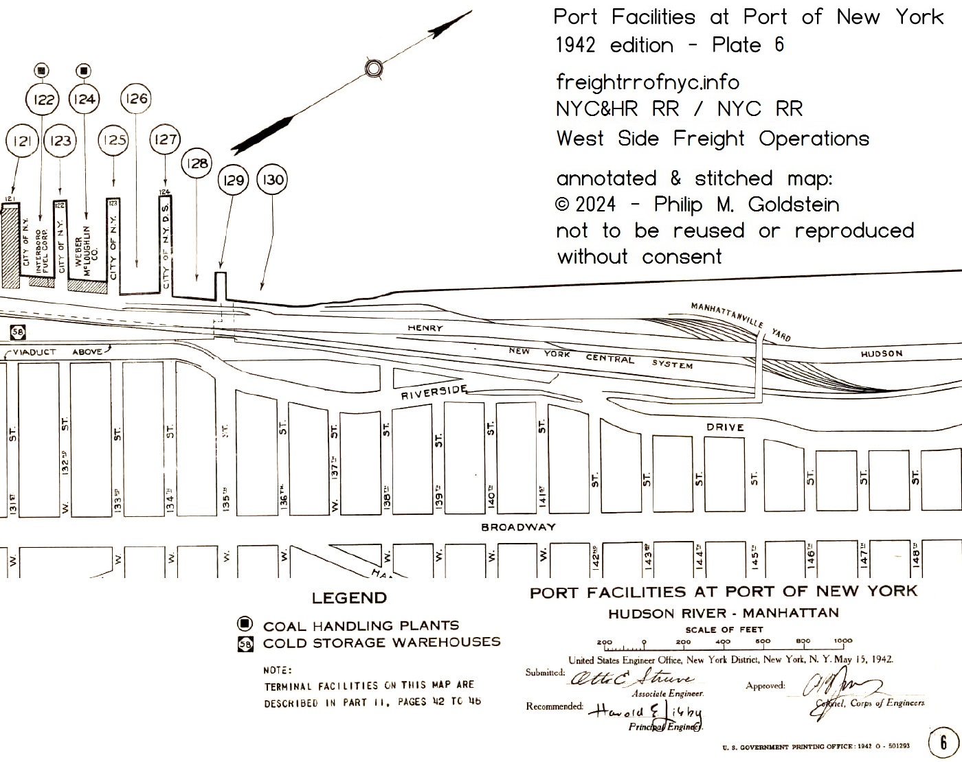
Port Facilities at Port of New York - 1942
Plate
6, West 131st Street to West 148th Street, Manhattanville Yard.
Key numbers correspond to lists contained in Port
and Terminal Facilities at Port of New York; Part 1; commencing on page
60.
Yes,
I have a copy, please email
if needed.
authors
collection
added
29 April 2024
.
.
1916/1942 - New York Central Railroad - Siding Location Chart
New York Central RR Siding Location Chart -
1942
Sheet
129 -
St. Johns Park Terminal to West 18th Street
Dashed line shows main tracks
(north to right)
courtesy of A.
Galanty
added
13 August 2025
.
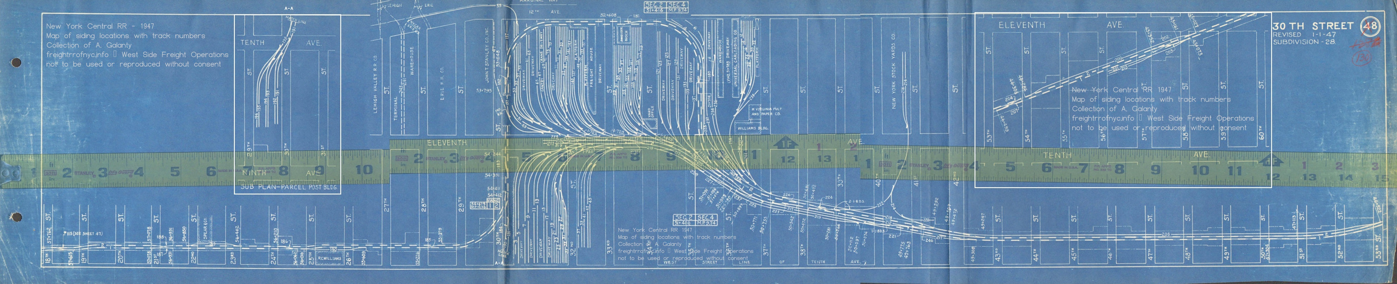
New York Central RR Siding Location Chart -
1947
Sheet 130 - West 18th Street to West 60th
Street,
including West
30th Street Yard, West 33rd Street Freight Terminal, West 36th Street
Yard, West 41st Street spur to Stock Yard & Slaughterhouses,
Parcel Post Building
Dashed line shows main tracks
(north to right)
courtesy of A.
Galanty
added
13 August 2025
.
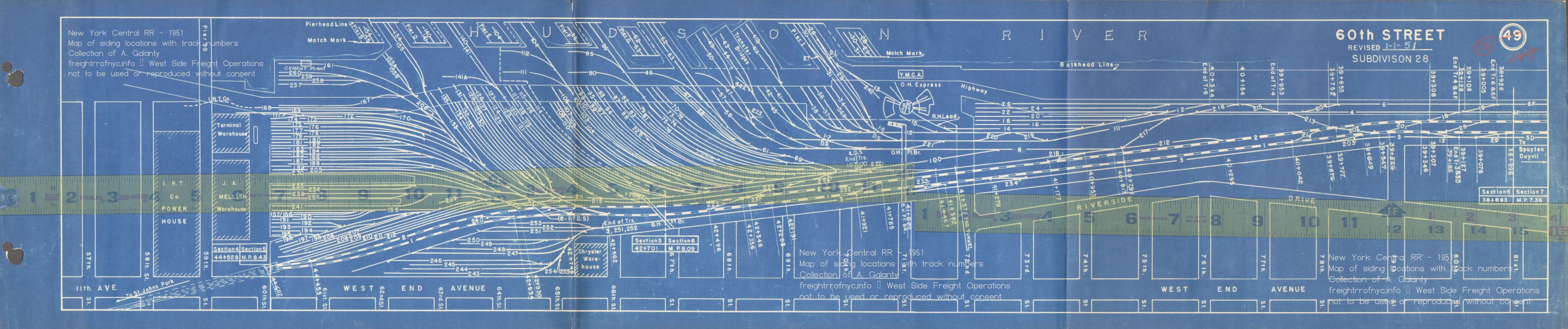
New York Central RR Siding Location Chart -
1951
Sheet 131 - West 57th Street to West 81th
Street,
including West
60th Street Yard, Turntable Roundhouse, Transfer Bridges, Stock Yards
Dashed line shows main tracks
(north to right)
courtesy of A.
Galanty
added
13 August 2025
.
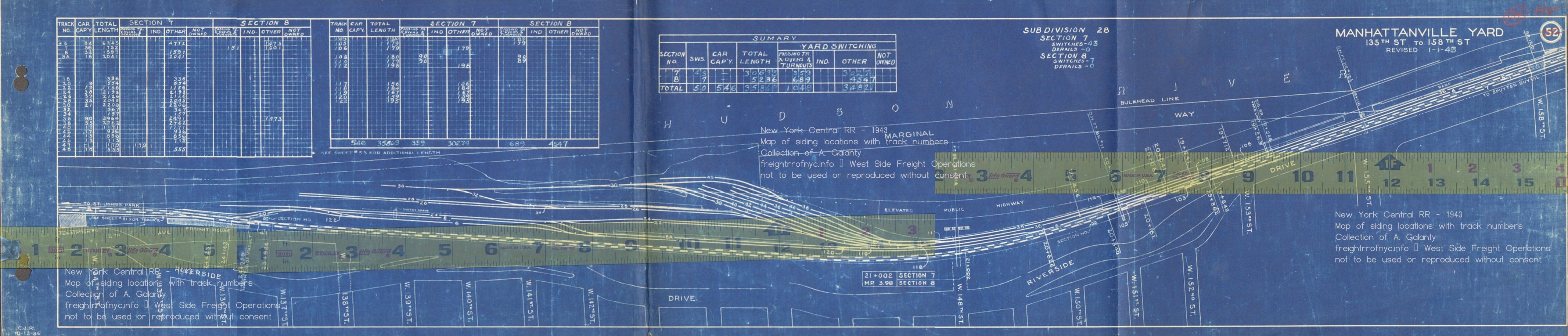
New York Central RR Siding Location Chart -
1945
Sheet 134 - West 135th Street to West 158th
Street,
including Manhattanville
Yard
Dashed line shows main tracks
(north to right)
courtesy of A.
Galanty
added
13 August 2025
.
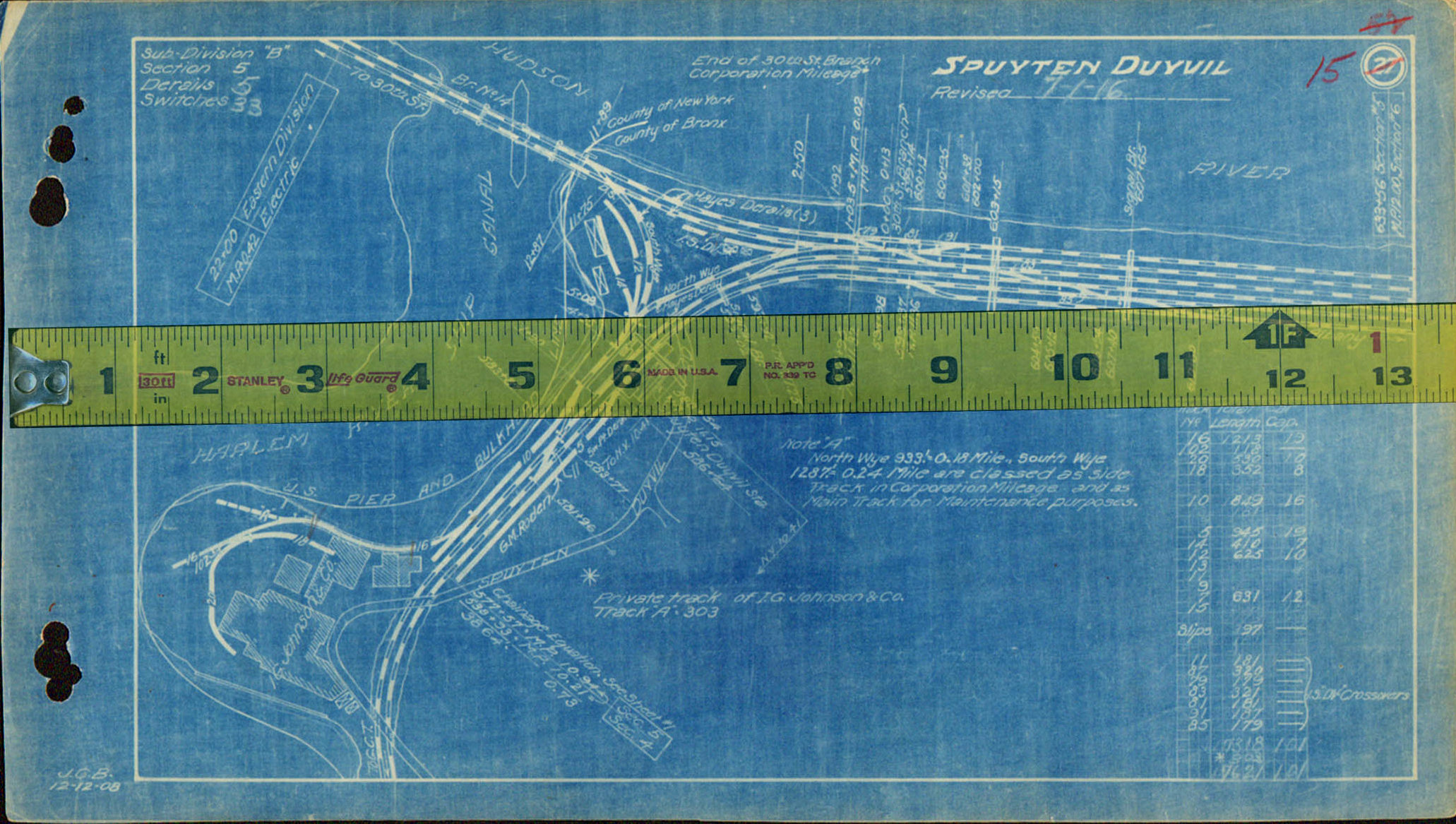
New York Central RR Siding Location Chart -
1916
Sheet 15 - Spuyten Duyvil
Dashed line shows main tracks
(north to right)
courtesy of A.
Galanty
added
13 August 2025
.
.
1955 - G. W. Bromley Property Atlas - West 73rd Street to West 59th Street
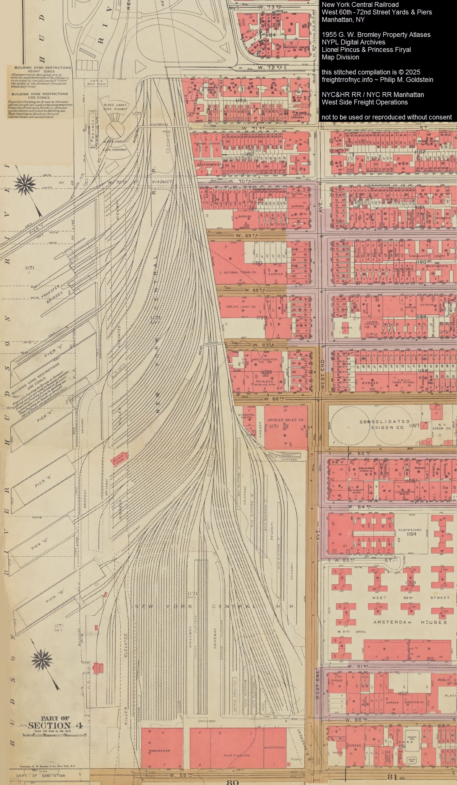
G. W. Bromley Property Atlas - 1955
stitched plates 86, 88, 90
New York Public Library Digital Collections
Lionel Pincus and Princess Firyal Map Division
added 05
April 2024
.
.
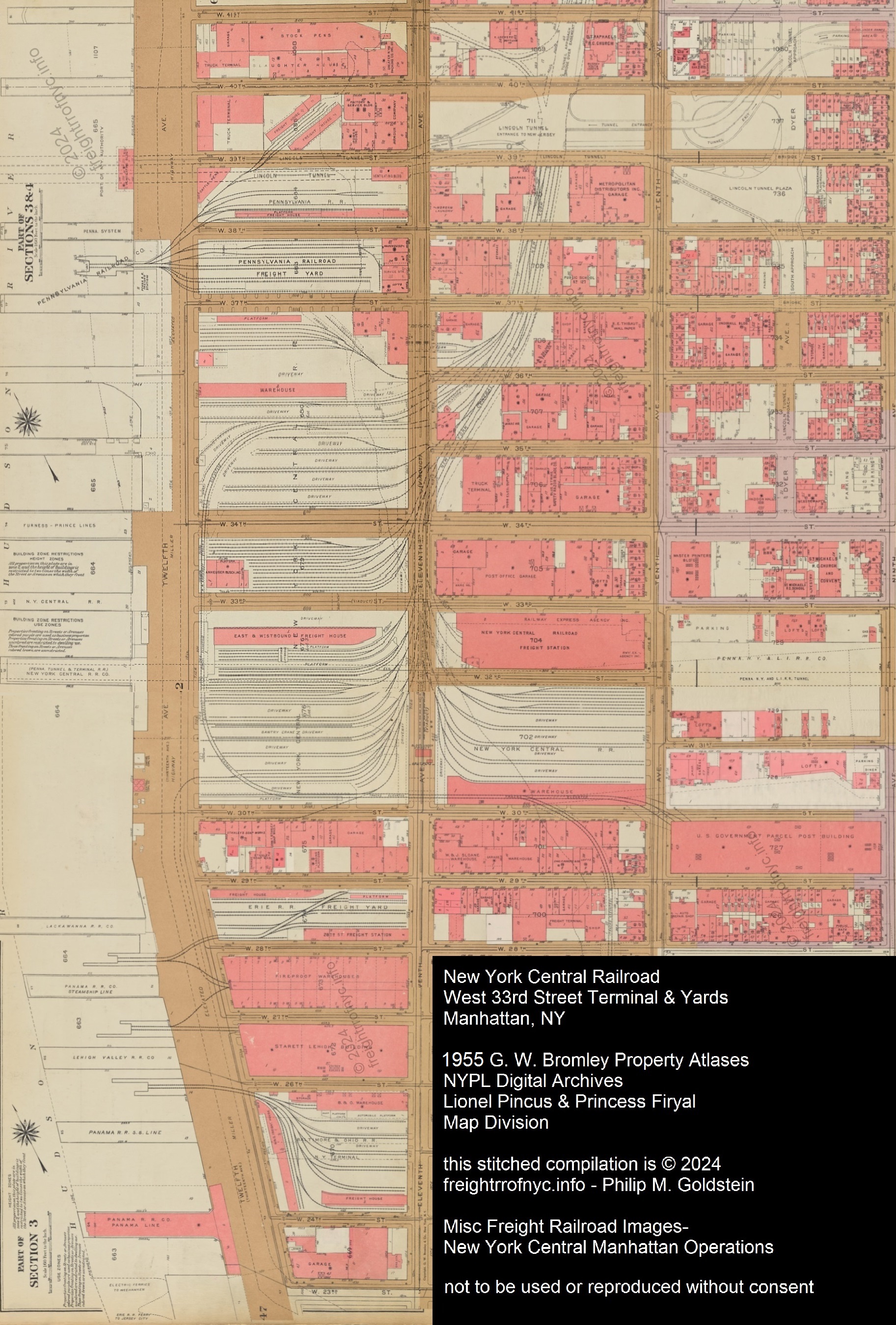
1955 - G. W. Bromley Property Atlas - West 41st Street to West 23rd Street
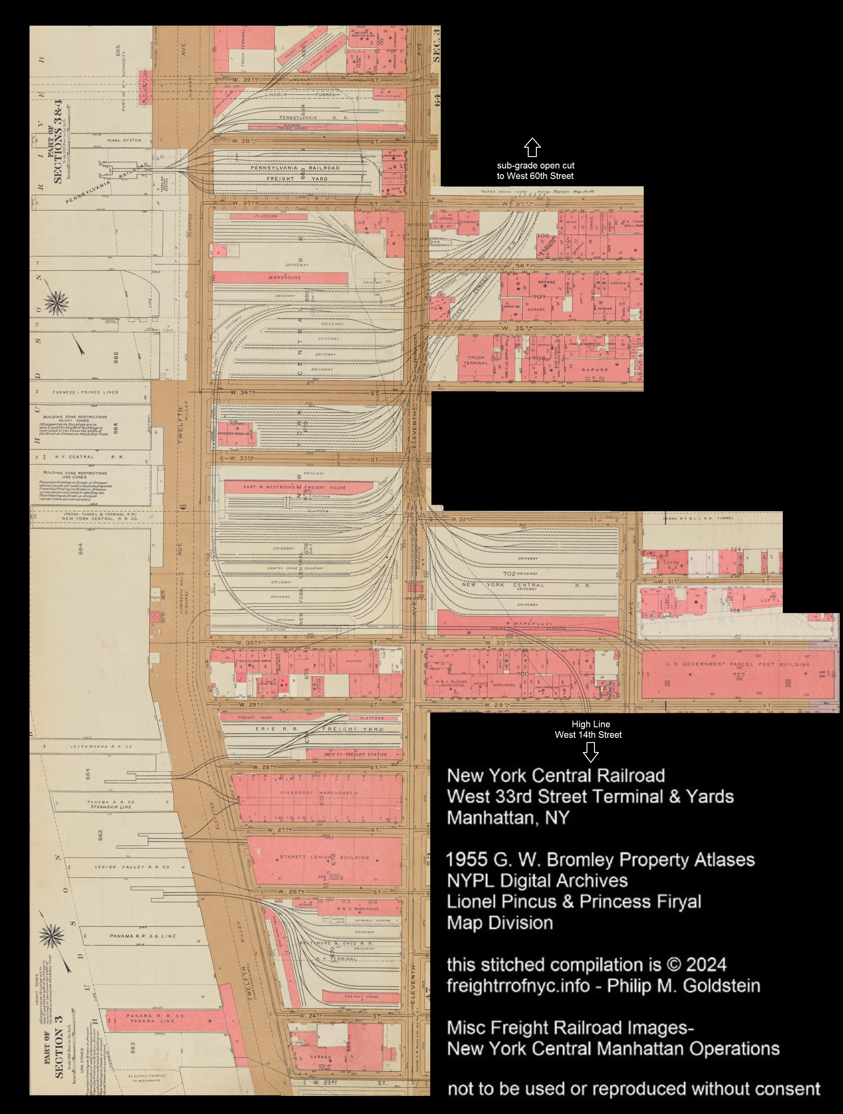
1955
Note:
Miller Elevated "West Side Highway", New York Central High Line and
1937 West Side sub-grade cut are present.
Pennsylvania RR West 37th Street Freight Station, New York Central West
36, West 35, West 34, West 33, West 32, West 31, West 30 Freight Yards
US Post Office Department Morgan Parcel Post Building, Erie West 28th
Street Freight Station, Terminal Warehouses, Starrett-Lehigh Building ,
Baltimore & Ohio RR West 26th Street Freight Station
Note
how the New York Central RR Twelfth Avenue trackage to the piers as
well as the Transfer Bridges and track leads has been eliminated as
well.
New York Public Library Digital Collections
Lionel Pincus and Princess Firyal Map Division
added 05
April 2024
| New York Central & Hudson River | 1846 - 1914 |
| New York Central Operations: New York Terminal District / Hudson Division / West 30th Street Branch |
1914 - 1968 |
| Penn Central Operations: New York Region - Hudson Division - West 30th Street Branch Northeast Region / Mohawk - Hudson Division - West 30th Street Branch |
1968 - 1976 1968 1974 |
| Conrail Northeastern Region - West 30th Street Secondary |
1976 - 1982 |
 Electric Division
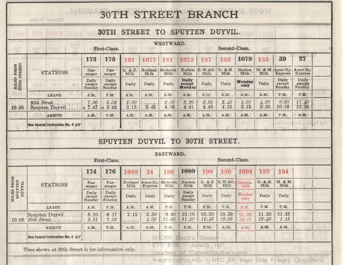
ETT #13B - June 26, 1921 outbound (wb): 173, 175 (passenger), 191, 1077, 181, 1075, 187, 183, 1079, 185 (milk), 39, 27 (AmRyEx)
inbound (eb): 174, 176 (passenger) 1088, 180, 1080, 190, 186, 1094, 184 (milk) 34 (AmRyEx) (red = Sunday movements) R&P = Rome & Potsdam? R&S = Rensselaer & Saratoga RW&O = Rome, Watertown & Ogdensburgh M&M = Mohawk & Malone canadasouthern.com collection |
 Electric Division
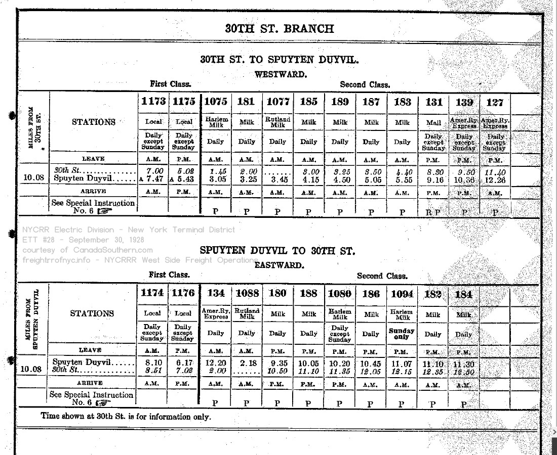
ETT #28 - September 30, 1928 outbound (wb): 1173, 1175 (passenger), 1075, 181, 1077, 185, 189, 187, 183 (milk), 131 (mail) 139, 127 (AmRyEx)
inbound (eb): 1174, 1176 (passenger), 134 (AmRyEx), 1088, 180, 188, 1080, 186, 1094, 182, 184 (milk) canadasouthern.com collection |
| . | |
 |
 |
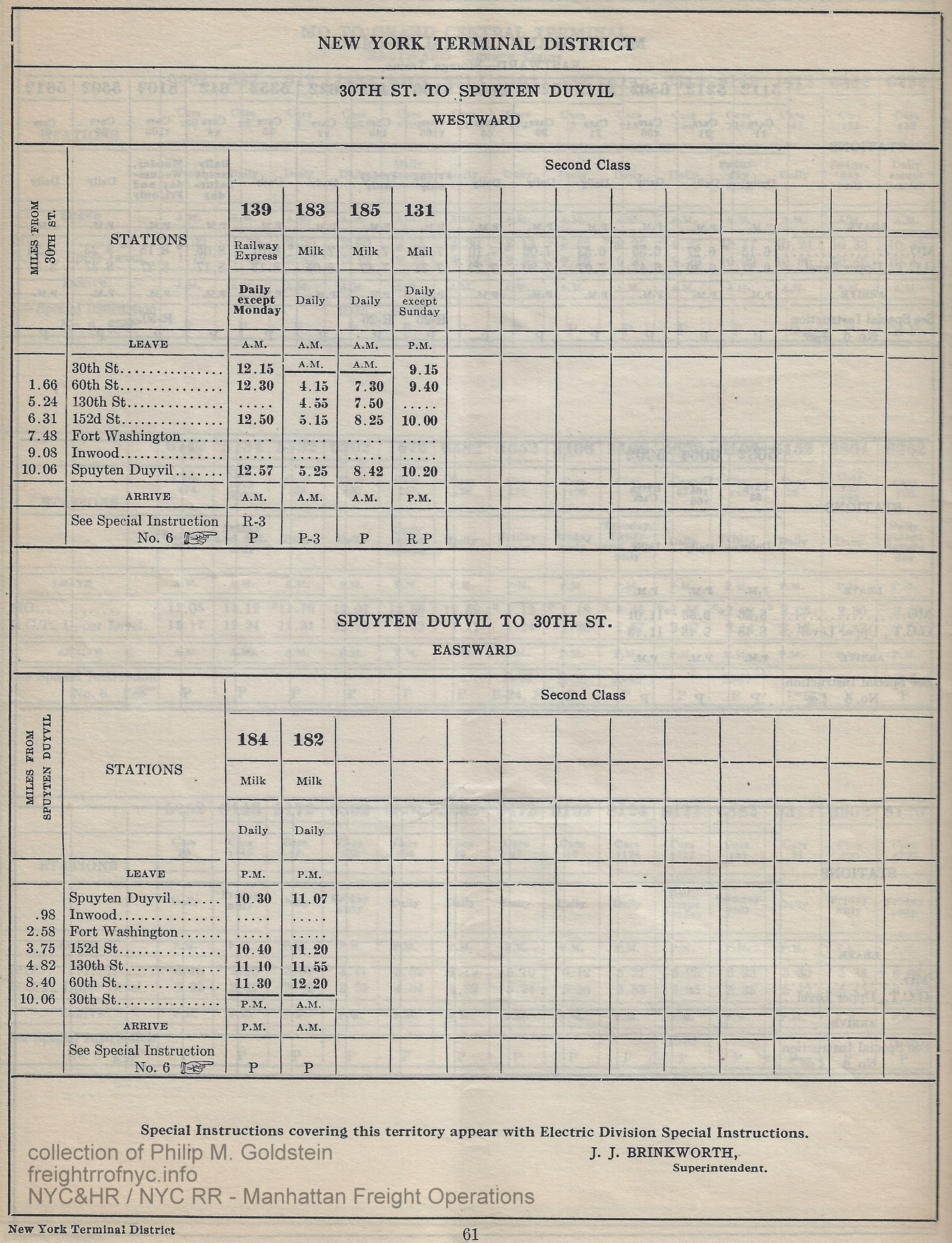
| Electric Division & New York Terminal District #47A - June 15, 1938; p61 Passenger trains no longer operated.
outbound (wb): Trains 139 (Railway Express); 183, 185 (milk), 131 (mail)
inbound (eb): 184, 182 (milk) Speed Restrictions: between West 36th Street and St Johns Park on the viaduct was 10 mph. Between St. Clair Place (West 125th Street) and West 137th Street was 30 mph, and north of West 135th Street to Spuyten Duyvil swingbridge was 45 mph. Locomotive Restrictions: West 33rd Street Farm Yard - all locomotives with pony trucks, east end of tracks 6, 7, 8 authors collection |
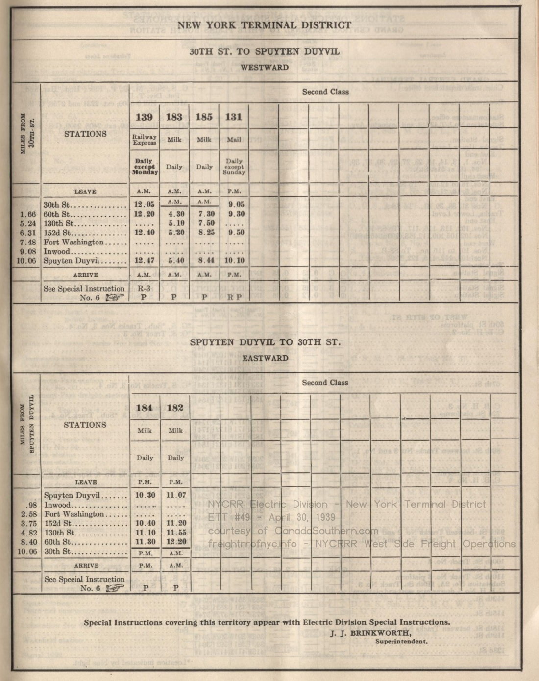
Electric Division & New York Terminal District #49 - April 30, 1939 outbound (wb): Trains 139 (Railway Express); 183, 185 (milk), 131 (mail)
inbound (eb): 184, 182 (milk) canadasouthern.com collection |
| . | |
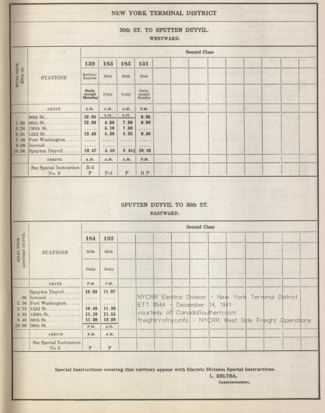 Electric Division & New York Terminal District
#54A - December 14, 1941 outbound (wb): 139 (Railway Express), 183, 185 (milk), 131 (mail),
inbound (eb): 184, 182 (milk) canadasouthern.com collection |
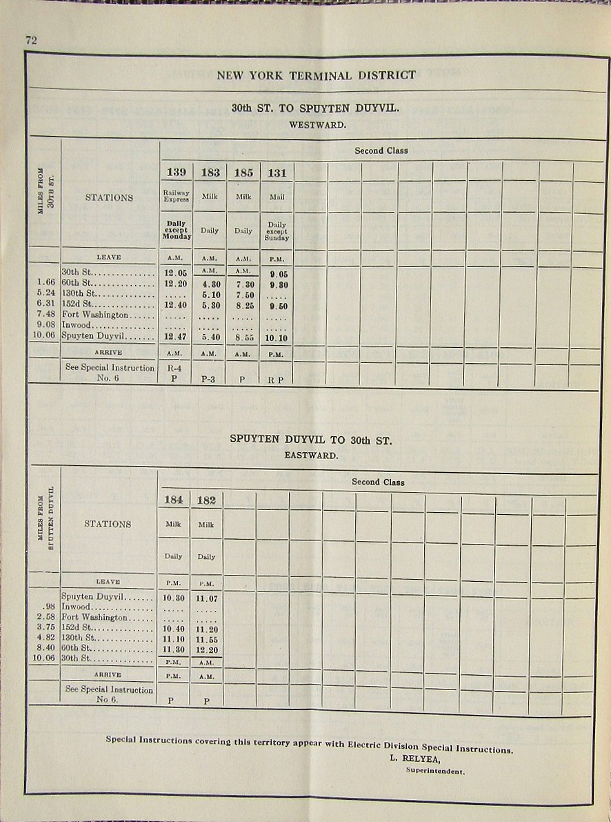 Electric Division & New York Terminal District
#56A - December 6, 1942 outbound (wb): 139 (Railway Express), 183, 185 (milk), 131 (mail),
inbound (eb): 184, 182 (milk) eBay |
| . | |
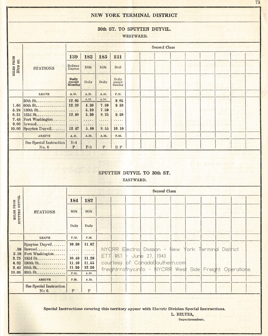
Electric Division & New York Terminal District
#57 - June 27, 1943 outbound (wb) 139 (Railway Express), 183, 185 (milk), 131 (mail),
inbound (eb): 184, 182 (milk) canadasouthern.com collection |
 Electric Division & New York Terminal District
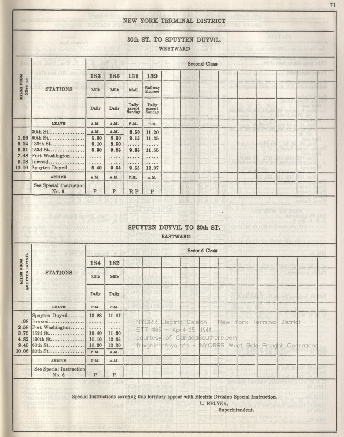
#65 - April 25, 1948 outbound (wb) 183, 185 (milk), 131 (mail),
inbound: (eb) 184, 182 (milk), 139 (Railway Express) to PM canadasouthern.com collection |
| . | |
 Electric Division & New York Terminal District
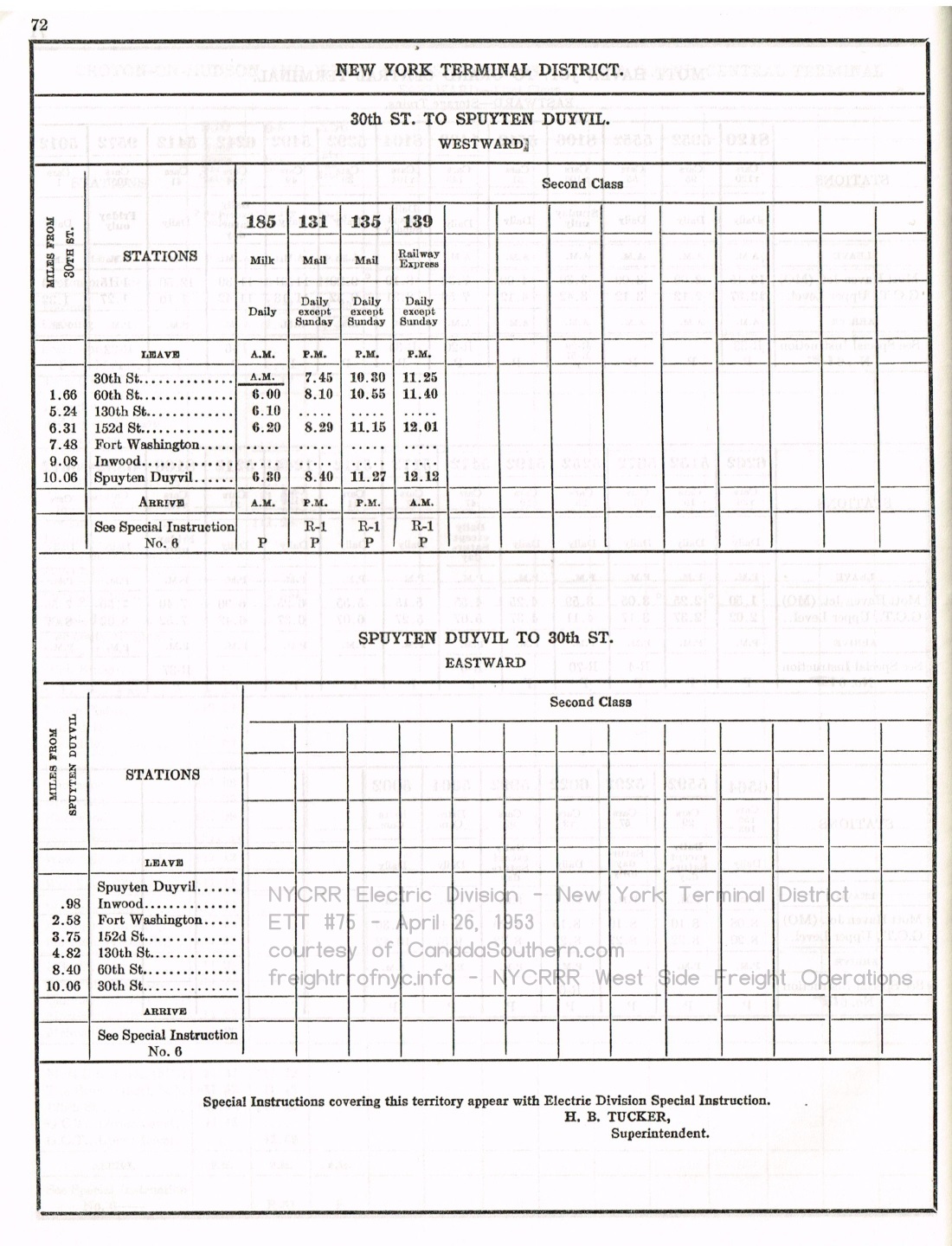
#75 - April 26, 1953 outbound (wb) 185 (milk), 131, 135 (mail), 139 (Railway Express)
canadasouthern.com
collectionno scheduled inbound (eb) |
 Electric Division & New York Terminal District
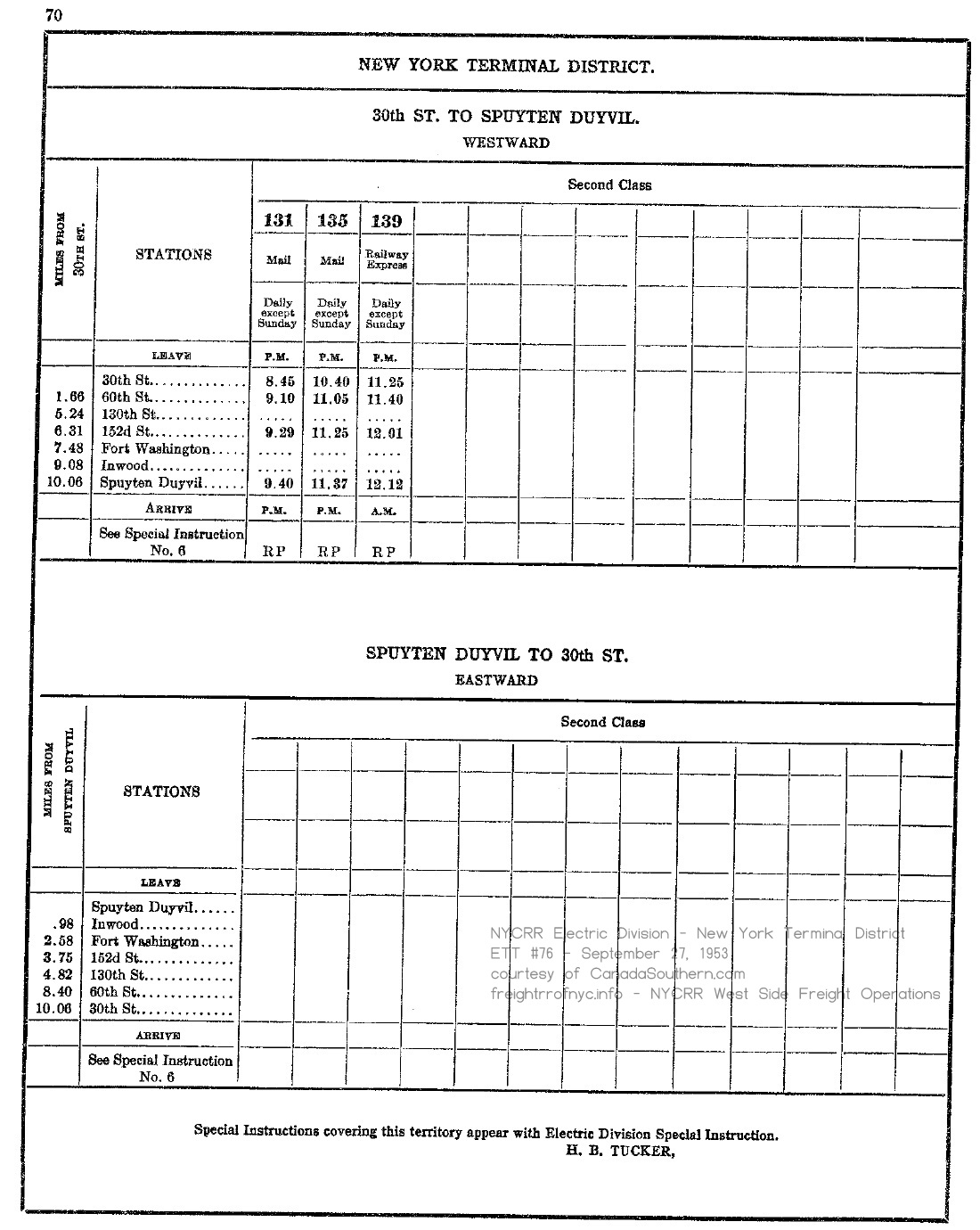
#76 - September 27, 1953 outbound (wb) 131, 135 (mail), 139 (Railway Express)
no scheduled inbound (eb) canadasouthern.com collection |
| . | |
 |
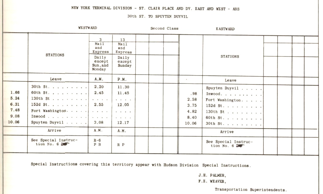 |
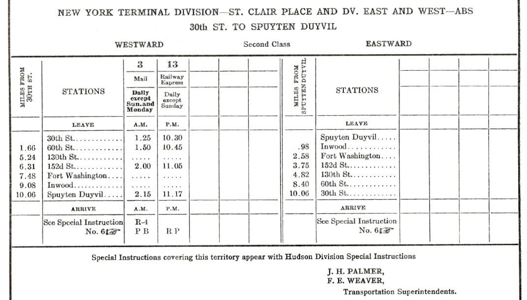
| Hudson Division & New York Terminal Division #7 - April 24, 1960; p89 outbound (wb) 3 (mail), 13 (Railway Express)
no scheduled inbound (eb) canadasouthern.com collection |
Hudson Division & New York Terminal Division #8 - October 30, 1960; p87 outbound (wb) 3 (mail), 13 (Railway Express)
no scheduled inbound (eb) canadasouthern.com collection |
| . | |
 |
 |
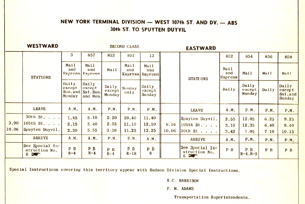
| Hudson Division & New York Terminal Division #14 - October 27, 1963; p113 outbound (wb) 3 (mail & express), 857 (mail & express), 853 (mail), 851 (mail & express), 13 (mail & express)
inbound (eb) 852 (mail & express), 854, 856, 858 (mail) canadasouthern.com collection |
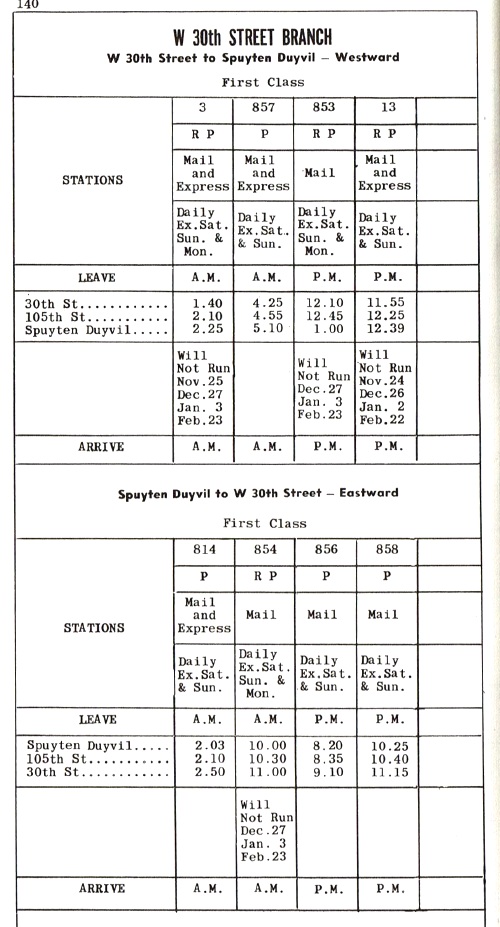
Hudson Division & New York Terminal Division #20 - October 30, 1966; p140 outbound (wb) 3 (mail & express), 857 (mail & express), 853 (mail), 851 (mail & express), 13 (mail & express)
inbound (eb) 852 (mail & express), 854, 856, 858 (mail) canadasouthern.com collection |
| . | |
 |
 |
|
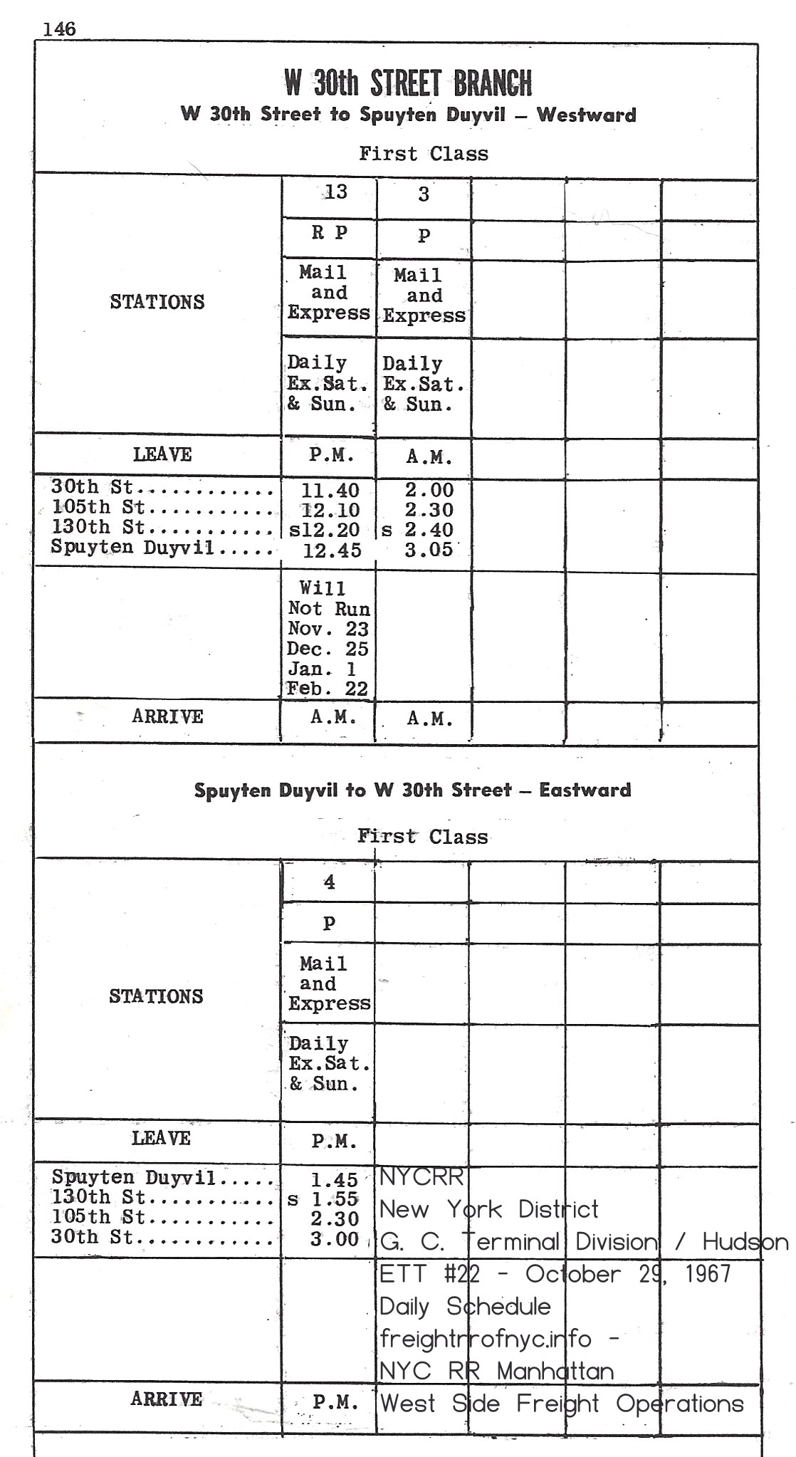
New York District - G. C. Terminal Division & Hudson Division
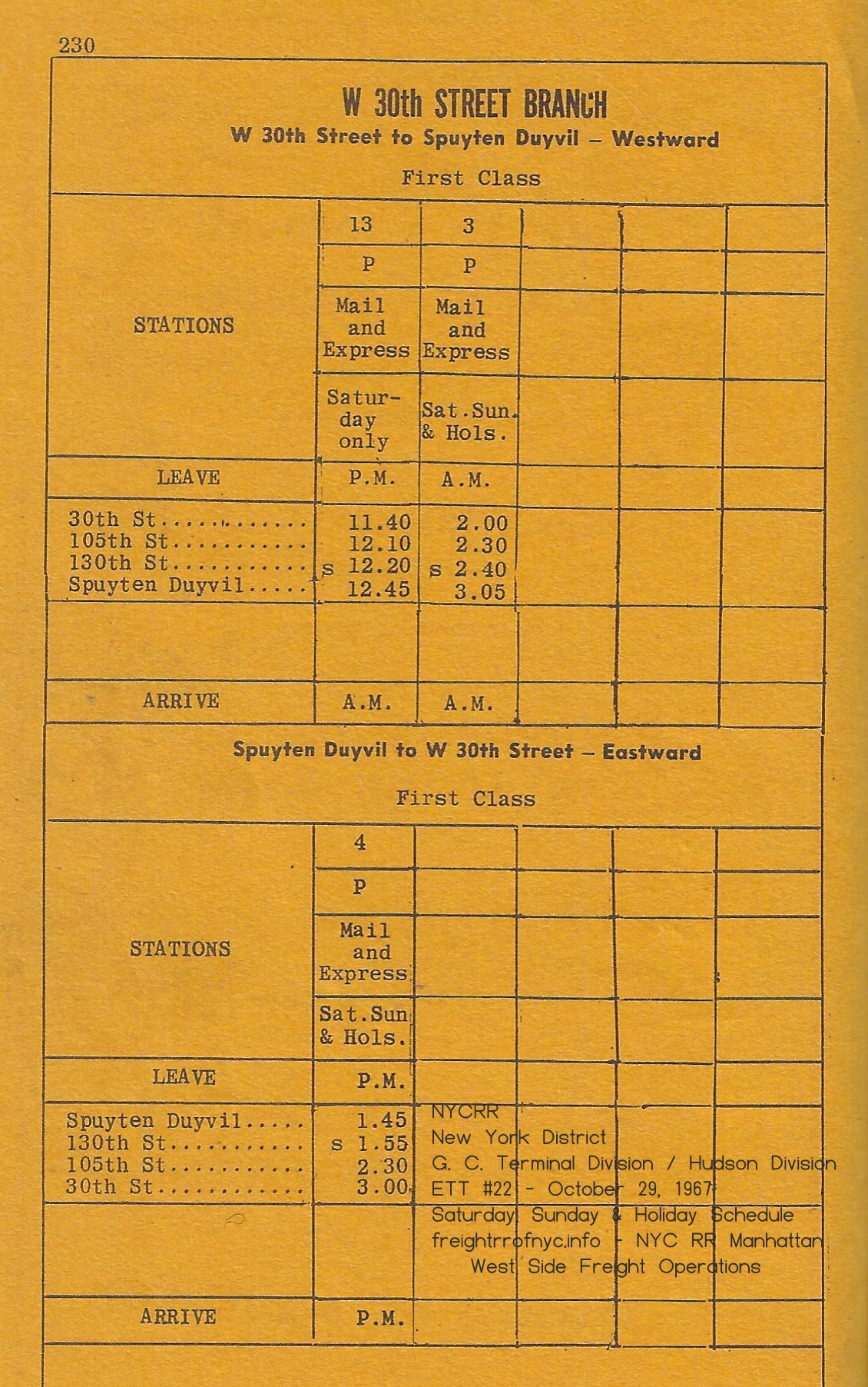
#22 - October 29, 1967; p146 Weekdays outbound (wb) 3 (mail & express), 857 (mail & express), 853 (mail), 851 (mail & express), 13 (mail & express) inbound (eb) 852 (mail & express), 854, 856, 858 (mail) |
New York District - G. C. Terminal Division & Hudson Division
#22 - October 29, 1967; p230 Saturday, Sunday & Holiday outbound (wb) 3 (mail & express), 857 (mail & express), 853 (mail), 851 (mail & express), 13 (mail & express) inbound (eb) 852 (mail & express), 854, 856, 858 (mail) |
 |
|
|
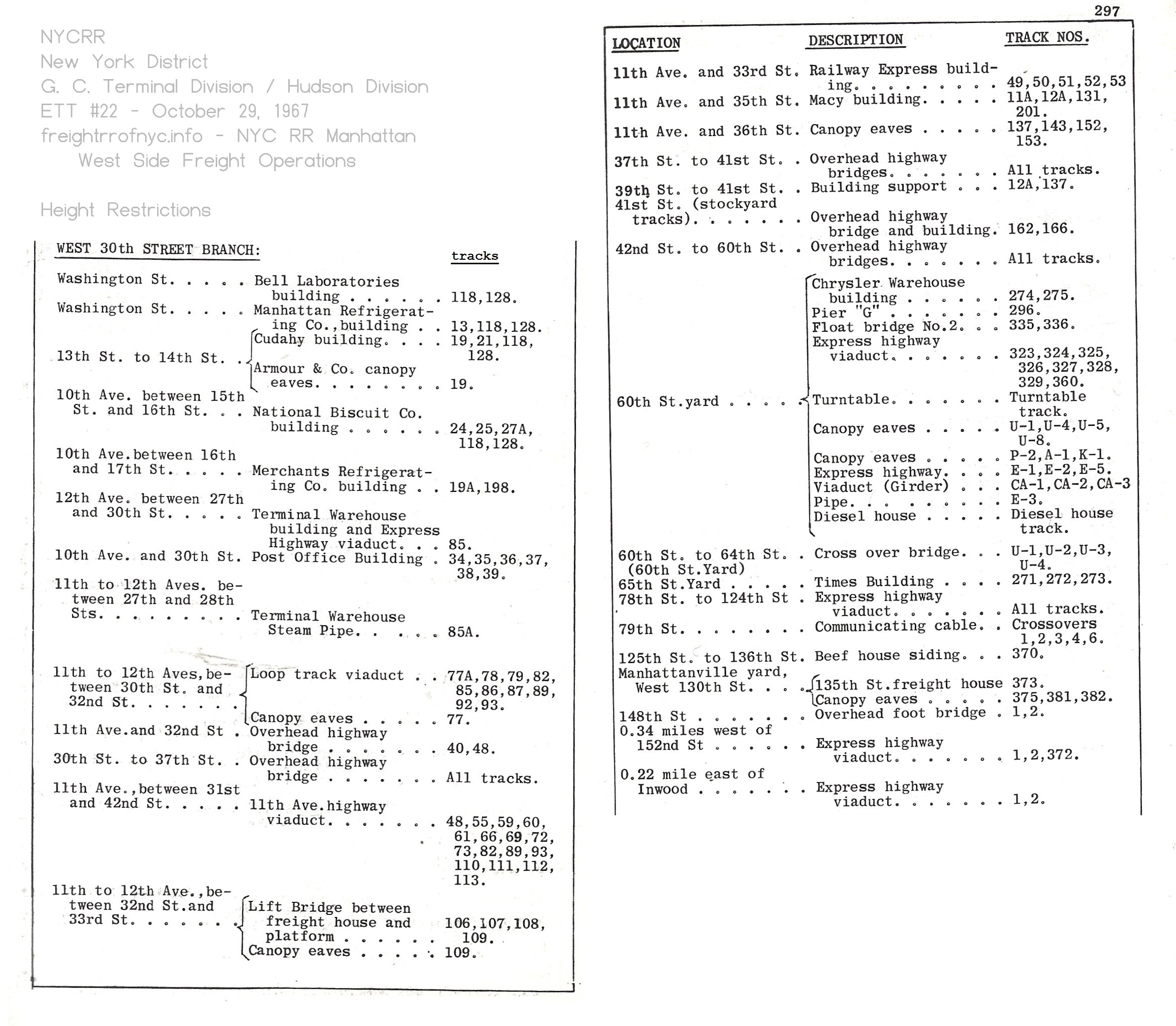
New York District - G. C. Terminal Division & Hudson Division
#22 - October 29, 1967; p296-297 height restrictions authors collection |
|

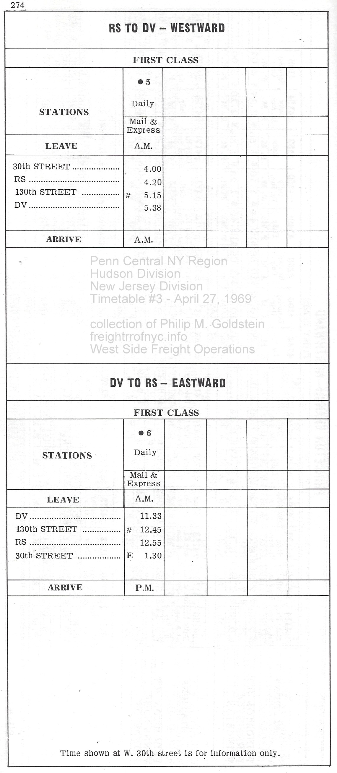 |
| Hudson Division & New Jersey Division #3 - April 27, 1969; p274 outbound (wb) #5 (mail & express)
intbound (eb) #6 (mail & express) #4 - October 26, 1969 p 274 (no changes for W30th St Branch) RS = RiverSide, DV = DuyVil authors collection |
| Outbound | |
 |
 |
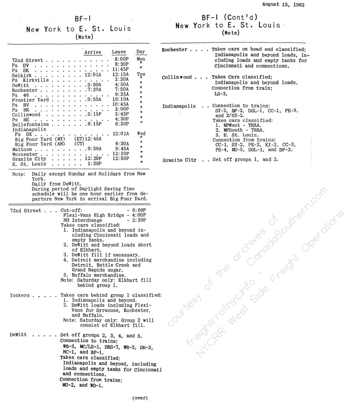
| BF-1 - West 72nd Street Yard, Manhattan, NY to East St. Louis, IL | BF-1 - West 72nd Street Yard, Manhattan, NY to Chicago, IL |
| . | |
| Inbound | |
 |
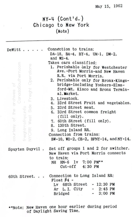 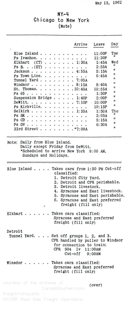 |
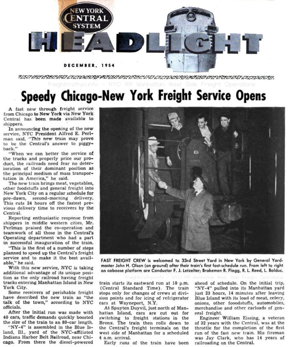
| NYC Headlight - December 1954 - NY-4 Freight Train Inaugurated | NY-4 - Chicago, IL to West 33rd Street Yard, Manhattan, NY (AM) |
| . | |
 |
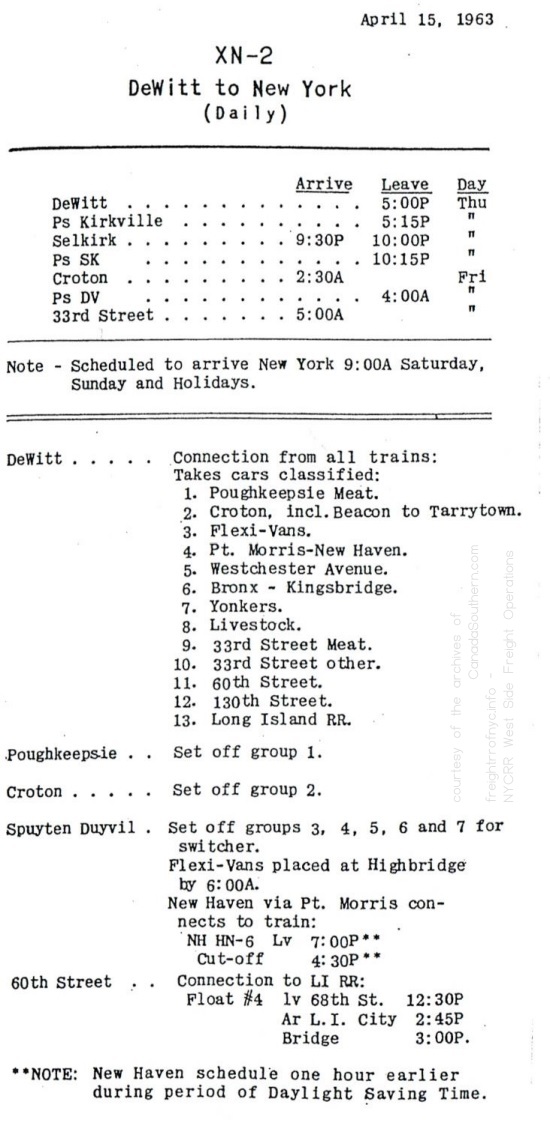 |
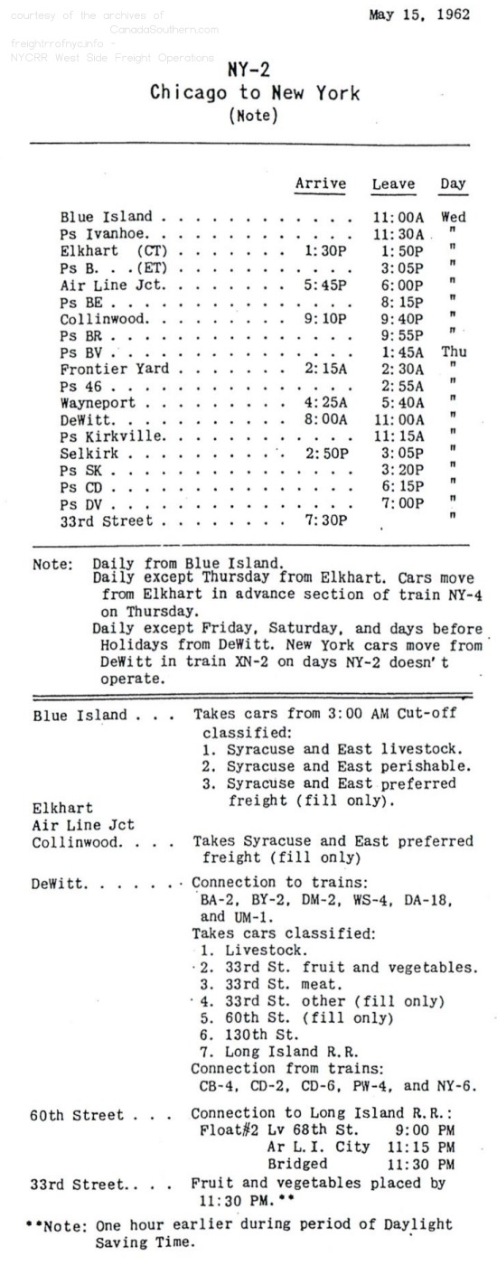
| NY-2 - Chicago, IL to West 33rd Street Yard, Manhattan, NY (PM) | XN-2 - Dewitt Yard, East Syracuse, NY to West 33rd Street Yard, Manhattan, NY |
| Outbound | Outbound | Inbound |
 |
 |
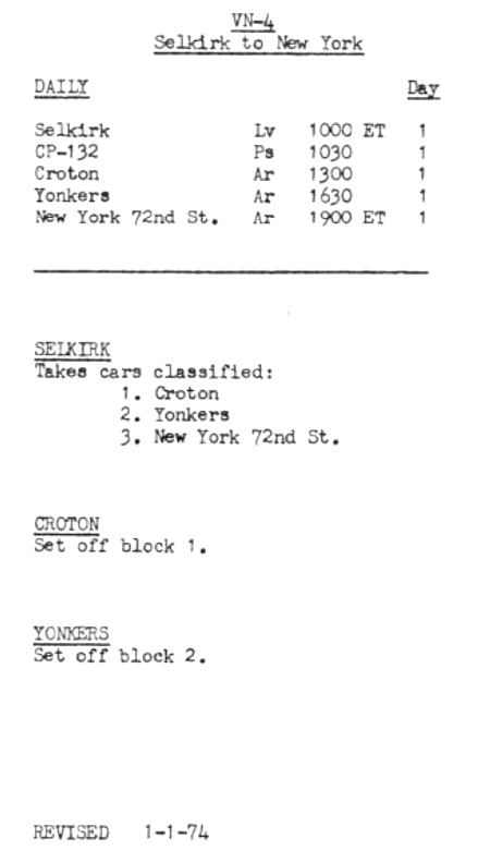 |
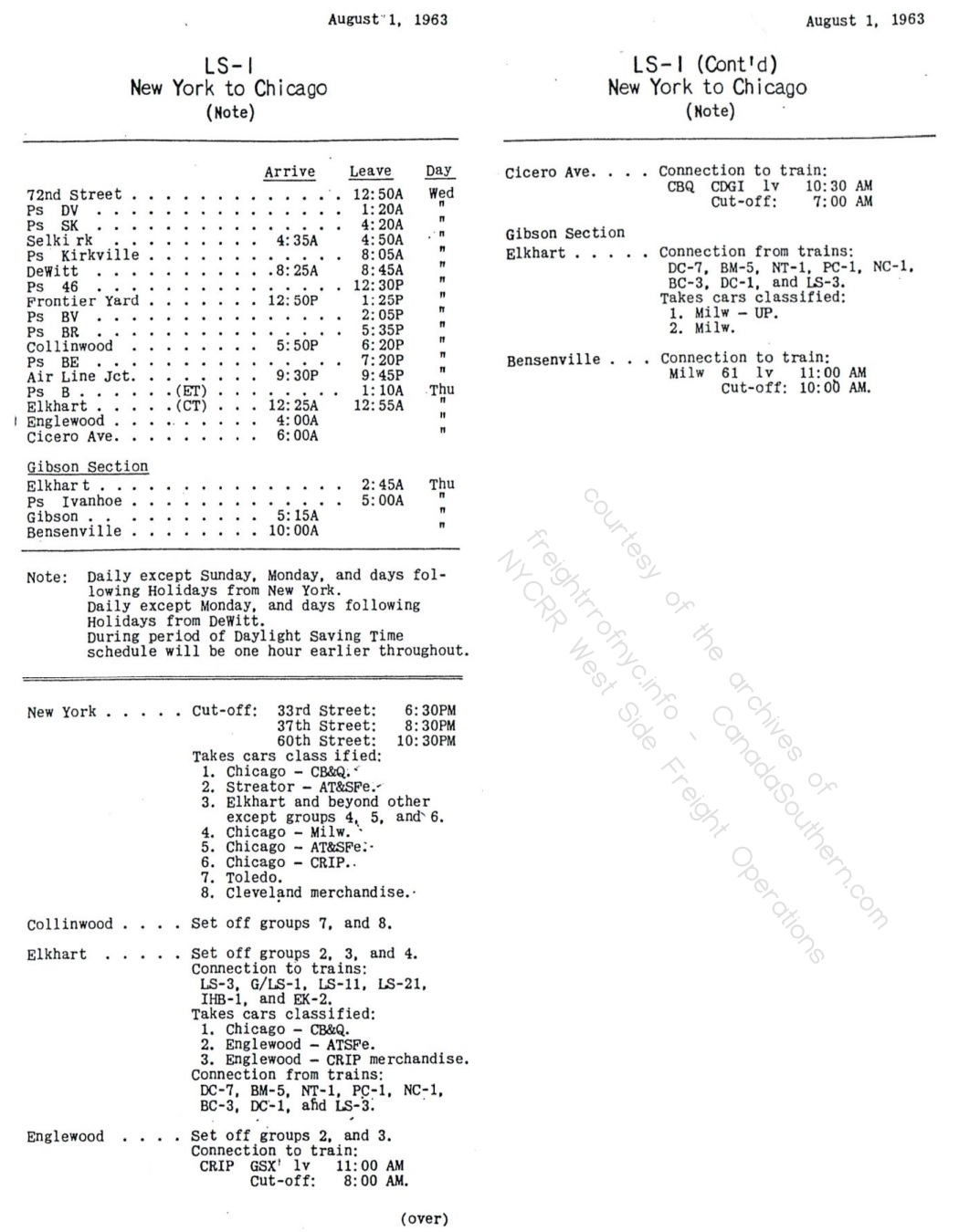
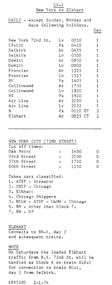
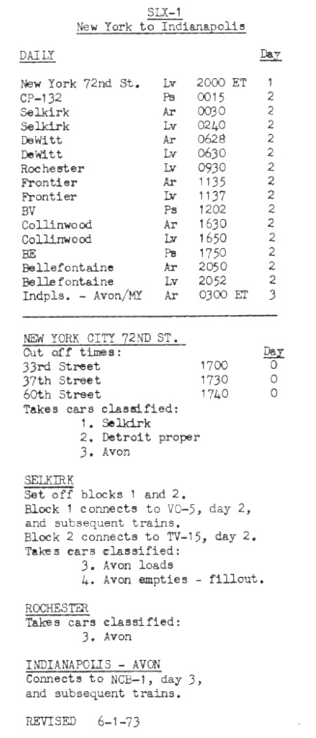
| LS-1 - West 72nd Street Yard, Manhattan, NY to Elkhart, IN | SLX-1 - West 72nd Street Yard, Manhattan, NY to Indianapolis, IN | VN-41 - Selkirk, NY to West 72nd Street Yard, Manhattan, NY |
| . | ||
 |
||
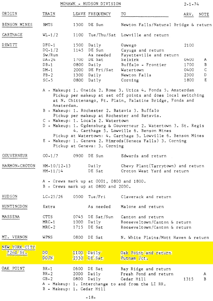
| Mohawk - Hudson Division Local Freight Schedule - New York City, 72nd Street DO - 11:00 Daily; Oak Point, the Bronx and return DOJN - 23:30 Daily except Saturday; Putnam Junction. |
||
| go to: | Page 1: | History and Operations: 1846 through 1941 (street operations) |
| go to: | Page 2: | History and Operations: 1926 through 1982 (West Side Improvement; High Line & sub-grade cut operations) |
| go to: | Page 3: | Locomotive & Equipment Histories, Rosters & Images |
| you are on: | Page 4: | Maps & Employee Timetables |
Like what you see? Suggestions?
Comments?


